Anasuya Barik, Sanjeeb Kumar Sahoo, Sarita Kumari, Somnath Baidya Roy
{"title":"利用动态降尺度技术建立印度高分辨率气候预测数据集","authors":"Anasuya Barik, Sanjeeb Kumar Sahoo, Sarita Kumari, Somnath Baidya Roy","doi":"10.1002/gdj3.266","DOIUrl":null,"url":null,"abstract":"<p>High-resolution climate projections are valuable resources for understanding the regional impacts of climate change and developing appropriate adaptation/mitigation strategies. In this study, we developed a 10-km gridded hydrometeorological dataset over India by dynamic downscaling of the bias-corrected Community Earth System Model (CESMv1) climate projections under RCP8.5 scenario using the state-of-the-art Weather Research and Forecasting (WRF) model. The downscaled CESM dataset (DSCESM) is archived in the World Data Center for Climate (WDCC) portal at three temporal resolutions (daily, monthly and monthly climatology) for current (2006–2015), mid-century (2041–2050) and end-century (2091–2100) periods. The dataset includes 2-m air temperature, total accumulated precipitation, wind speed, relative humidity, sensible and latent heat fluxes, along with surface shortwave and outgoing longwave radiation. All the DSCESM variables were evaluated against reanalysis data and station observations for the period 2006–2015. This dataset can help us quantitatively understand regional climate change in India. It can also be used in conjunction with agricultural, hydrological, fire and other application models for climate change impact assessment on various sectors to help develop effective adaptation/mitigation strategies.</p>","PeriodicalId":54351,"journal":{"name":"Geoscience Data Journal","volume":"11 4","pages":"921-935"},"PeriodicalIF":2.4000,"publicationDate":"2024-07-11","publicationTypes":"Journal Article","fieldsOfStudy":null,"isOpenAccess":false,"openAccessPdf":"https://onlinelibrary.wiley.com/doi/epdf/10.1002/gdj3.266","citationCount":"0","resultStr":"{\"title\":\"High-resolution climate projection dataset over India using dynamical downscaling\",\"authors\":\"Anasuya Barik, Sanjeeb Kumar Sahoo, Sarita Kumari, Somnath Baidya Roy\",\"doi\":\"10.1002/gdj3.266\",\"DOIUrl\":null,\"url\":null,\"abstract\":\"<p>High-resolution climate projections are valuable resources for understanding the regional impacts of climate change and developing appropriate adaptation/mitigation strategies. In this study, we developed a 10-km gridded hydrometeorological dataset over India by dynamic downscaling of the bias-corrected Community Earth System Model (CESMv1) climate projections under RCP8.5 scenario using the state-of-the-art Weather Research and Forecasting (WRF) model. The downscaled CESM dataset (DSCESM) is archived in the World Data Center for Climate (WDCC) portal at three temporal resolutions (daily, monthly and monthly climatology) for current (2006–2015), mid-century (2041–2050) and end-century (2091–2100) periods. The dataset includes 2-m air temperature, total accumulated precipitation, wind speed, relative humidity, sensible and latent heat fluxes, along with surface shortwave and outgoing longwave radiation. All the DSCESM variables were evaluated against reanalysis data and station observations for the period 2006–2015. This dataset can help us quantitatively understand regional climate change in India. It can also be used in conjunction with agricultural, hydrological, fire and other application models for climate change impact assessment on various sectors to help develop effective adaptation/mitigation strategies.</p>\",\"PeriodicalId\":54351,\"journal\":{\"name\":\"Geoscience Data Journal\",\"volume\":\"11 4\",\"pages\":\"921-935\"},\"PeriodicalIF\":2.4000,\"publicationDate\":\"2024-07-11\",\"publicationTypes\":\"Journal Article\",\"fieldsOfStudy\":null,\"isOpenAccess\":false,\"openAccessPdf\":\"https://onlinelibrary.wiley.com/doi/epdf/10.1002/gdj3.266\",\"citationCount\":\"0\",\"resultStr\":null,\"platform\":\"Semanticscholar\",\"paperid\":null,\"PeriodicalName\":\"Geoscience Data Journal\",\"FirstCategoryId\":\"89\",\"ListUrlMain\":\"https://rmets.onlinelibrary.wiley.com/doi/10.1002/gdj3.266\",\"RegionNum\":3,\"RegionCategory\":\"地球科学\",\"ArticlePicture\":[],\"TitleCN\":null,\"AbstractTextCN\":null,\"PMCID\":null,\"EPubDate\":\"\",\"PubModel\":\"\",\"JCR\":\"Q2\",\"JCRName\":\"GEOSCIENCES, MULTIDISCIPLINARY\",\"Score\":null,\"Total\":0}","platform":"Semanticscholar","paperid":null,"PeriodicalName":"Geoscience Data Journal","FirstCategoryId":"89","ListUrlMain":"https://rmets.onlinelibrary.wiley.com/doi/10.1002/gdj3.266","RegionNum":3,"RegionCategory":"地球科学","ArticlePicture":[],"TitleCN":null,"AbstractTextCN":null,"PMCID":null,"EPubDate":"","PubModel":"","JCR":"Q2","JCRName":"GEOSCIENCES, MULTIDISCIPLINARY","Score":null,"Total":0}
High-resolution climate projection dataset over India using dynamical downscaling
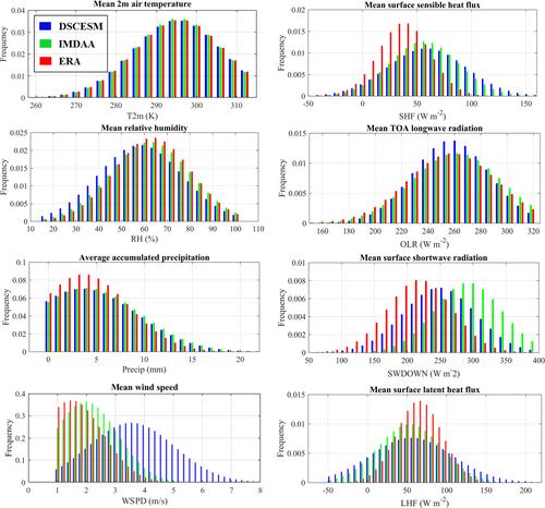
High-resolution climate projections are valuable resources for understanding the regional impacts of climate change and developing appropriate adaptation/mitigation strategies. In this study, we developed a 10-km gridded hydrometeorological dataset over India by dynamic downscaling of the bias-corrected Community Earth System Model (CESMv1) climate projections under RCP8.5 scenario using the state-of-the-art Weather Research and Forecasting (WRF) model. The downscaled CESM dataset (DSCESM) is archived in the World Data Center for Climate (WDCC) portal at three temporal resolutions (daily, monthly and monthly climatology) for current (2006–2015), mid-century (2041–2050) and end-century (2091–2100) periods. The dataset includes 2-m air temperature, total accumulated precipitation, wind speed, relative humidity, sensible and latent heat fluxes, along with surface shortwave and outgoing longwave radiation. All the DSCESM variables were evaluated against reanalysis data and station observations for the period 2006–2015. This dataset can help us quantitatively understand regional climate change in India. It can also be used in conjunction with agricultural, hydrological, fire and other application models for climate change impact assessment on various sectors to help develop effective adaptation/mitigation strategies.
Geoscience Data JournalGEOSCIENCES, MULTIDISCIPLINARYMETEOROLOGY-METEOROLOGY & ATMOSPHERIC SCIENCES
CiteScore
5.90
自引率
9.40%
发文量
35
审稿时长
4 weeks
期刊介绍:
Geoscience Data Journal provides an Open Access platform where scientific data can be formally published, in a way that includes scientific peer-review. Thus the dataset creator attains full credit for their efforts, while also improving the scientific record, providing version control for the community and allowing major datasets to be fully described, cited and discovered.
An online-only journal, GDJ publishes short data papers cross-linked to – and citing – datasets that have been deposited in approved data centres and awarded DOIs. The journal will also accept articles on data services, and articles which support and inform data publishing best practices.
Data is at the heart of science and scientific endeavour. The curation of data and the science associated with it is as important as ever in our understanding of the changing earth system and thereby enabling us to make future predictions. Geoscience Data Journal is working with recognised Data Centres across the globe to develop the future strategy for data publication, the recognition of the value of data and the communication and exploitation of data to the wider science and stakeholder communities.


 分享
分享
 求助内容:
求助内容: 应助结果提醒方式:
 扫码关注我们
