Amos C. Muthiuru, Ramiro D. Crego, Jemimah A. Simbauni, Philip M. Muruthi, Grace Waiguchu, Fredrick Lala, James D. A. Millington, Eunice W. Kairu
{"title":"人类足迹和降雨决定了马赛长颈鹿在多用途景观中的栖息地适宜性和连通性","authors":"Amos C. Muthiuru, Ramiro D. Crego, Jemimah A. Simbauni, Philip M. Muruthi, Grace Waiguchu, Fredrick Lala, James D. A. Millington, Eunice W. Kairu","doi":"10.1002/ecs2.4933","DOIUrl":null,"url":null,"abstract":"<p>Giraffe populations have declined by around 40% in the last three decades. Climate change, poaching, habitat loss, and increasing human pressures are confining giraffes to smaller and more isolated patches of habitats. Masai giraffes (<i>Giraffa tippelskirchi</i>) have been subjected to habitat loss and fragmentation, diseases, poaching, and unpredictable calamities such as wildfires and climate change. In this study, we aimed to identify (1) suitable Masai giraffe habitats within the transboundary landscape of Tsavo-Mkomazi in Southern Kenya and Northern Tanzania; and (2) key connecting corridors in a multiple-use landscape for conservation prioritization. We combined Masai giraffe presence data collected through a total aerial survey with moderate resolution satellite data to model habitat suitability at 250 m resolution using species distribution models (SDMs) implemented in Google Earth Engine (GEE). Model accuracy was assessed using area under precision recall curve (AUC-PR). We then used the habitat suitability index as a resistance surface to model functional connectivity using Circuitscape theory and cost-weighted distance pairwise methods. Human habitat modification, rainfall, and elevation were the main model predictors of Masai giraffe habitat and corridors. On average, our 10-fold model fitting attained a good predictive performance with an average AUC-PR = 0.80 (SD = 0.01, range = 0.79–0.83). The model predicted an area of 15,002 km<sup>2</sup> as potential suitable Masai giraffe habitat with over 17% outside protected areas within the landscape. Although Tsavo West National Park formed a key habitat and a key connecting corridor, nonprotected community ranches connecting Tsavo West and Tsavo East National Parks are equally important in maintaining landscape connectivity joining more than two Masai giraffe core areas with low resistance and high permeability. To maintain critical Masai giraffe's habitats and landscape functional connectivity, especially in multiple-use landscapes, conservation-compatible land use practices, capacity building, and land use planning should be considered at the outset of any new infrastructure development and land use changes. This modeling shows the potential of utilizing remotely sensed information and ground surveys to guide the management of habitats and their connecting corridors across important African landscapes, complementing existing efforts to identify, conserve, and protect wildlife habitats and their linkage zones.</p>","PeriodicalId":48930,"journal":{"name":"Ecosphere","volume":"15 7","pages":""},"PeriodicalIF":3.0000,"publicationDate":"2024-07-15","publicationTypes":"Journal Article","fieldsOfStudy":null,"isOpenAccess":false,"openAccessPdf":"https://onlinelibrary.wiley.com/doi/epdf/10.1002/ecs2.4933","citationCount":"0","resultStr":"{\"title\":\"Human footprint and rainfall shape Masai giraffe's habitat suitability and connectivity in a multiple-use landscape\",\"authors\":\"Amos C. Muthiuru, Ramiro D. Crego, Jemimah A. Simbauni, Philip M. Muruthi, Grace Waiguchu, Fredrick Lala, James D. A. Millington, Eunice W. Kairu\",\"doi\":\"10.1002/ecs2.4933\",\"DOIUrl\":null,\"url\":null,\"abstract\":\"<p>Giraffe populations have declined by around 40% in the last three decades. Climate change, poaching, habitat loss, and increasing human pressures are confining giraffes to smaller and more isolated patches of habitats. Masai giraffes (<i>Giraffa tippelskirchi</i>) have been subjected to habitat loss and fragmentation, diseases, poaching, and unpredictable calamities such as wildfires and climate change. In this study, we aimed to identify (1) suitable Masai giraffe habitats within the transboundary landscape of Tsavo-Mkomazi in Southern Kenya and Northern Tanzania; and (2) key connecting corridors in a multiple-use landscape for conservation prioritization. We combined Masai giraffe presence data collected through a total aerial survey with moderate resolution satellite data to model habitat suitability at 250 m resolution using species distribution models (SDMs) implemented in Google Earth Engine (GEE). Model accuracy was assessed using area under precision recall curve (AUC-PR). We then used the habitat suitability index as a resistance surface to model functional connectivity using Circuitscape theory and cost-weighted distance pairwise methods. Human habitat modification, rainfall, and elevation were the main model predictors of Masai giraffe habitat and corridors. On average, our 10-fold model fitting attained a good predictive performance with an average AUC-PR = 0.80 (SD = 0.01, range = 0.79–0.83). The model predicted an area of 15,002 km<sup>2</sup> as potential suitable Masai giraffe habitat with over 17% outside protected areas within the landscape. Although Tsavo West National Park formed a key habitat and a key connecting corridor, nonprotected community ranches connecting Tsavo West and Tsavo East National Parks are equally important in maintaining landscape connectivity joining more than two Masai giraffe core areas with low resistance and high permeability. To maintain critical Masai giraffe's habitats and landscape functional connectivity, especially in multiple-use landscapes, conservation-compatible land use practices, capacity building, and land use planning should be considered at the outset of any new infrastructure development and land use changes. This modeling shows the potential of utilizing remotely sensed information and ground surveys to guide the management of habitats and their connecting corridors across important African landscapes, complementing existing efforts to identify, conserve, and protect wildlife habitats and their linkage zones.</p>\",\"PeriodicalId\":48930,\"journal\":{\"name\":\"Ecosphere\",\"volume\":\"15 7\",\"pages\":\"\"},\"PeriodicalIF\":3.0000,\"publicationDate\":\"2024-07-15\",\"publicationTypes\":\"Journal Article\",\"fieldsOfStudy\":null,\"isOpenAccess\":false,\"openAccessPdf\":\"https://onlinelibrary.wiley.com/doi/epdf/10.1002/ecs2.4933\",\"citationCount\":\"0\",\"resultStr\":null,\"platform\":\"Semanticscholar\",\"paperid\":null,\"PeriodicalName\":\"Ecosphere\",\"FirstCategoryId\":\"93\",\"ListUrlMain\":\"https://esajournals.onlinelibrary.wiley.com/doi/10.1002/ecs2.4933\",\"RegionNum\":3,\"RegionCategory\":\"环境科学与生态学\",\"ArticlePicture\":[],\"TitleCN\":null,\"AbstractTextCN\":null,\"PMCID\":null,\"EPubDate\":\"\",\"PubModel\":\"\",\"JCR\":\"Q2\",\"JCRName\":\"ECOLOGY\",\"Score\":null,\"Total\":0}","platform":"Semanticscholar","paperid":null,"PeriodicalName":"Ecosphere","FirstCategoryId":"93","ListUrlMain":"https://esajournals.onlinelibrary.wiley.com/doi/10.1002/ecs2.4933","RegionNum":3,"RegionCategory":"环境科学与生态学","ArticlePicture":[],"TitleCN":null,"AbstractTextCN":null,"PMCID":null,"EPubDate":"","PubModel":"","JCR":"Q2","JCRName":"ECOLOGY","Score":null,"Total":0}
Human footprint and rainfall shape Masai giraffe's habitat suitability and connectivity in a multiple-use landscape
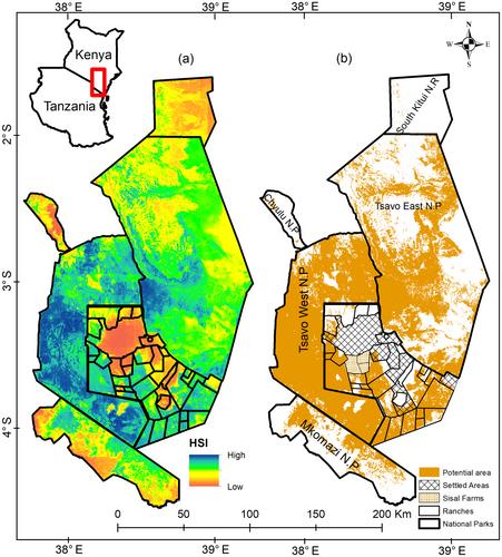
Giraffe populations have declined by around 40% in the last three decades. Climate change, poaching, habitat loss, and increasing human pressures are confining giraffes to smaller and more isolated patches of habitats. Masai giraffes (Giraffa tippelskirchi) have been subjected to habitat loss and fragmentation, diseases, poaching, and unpredictable calamities such as wildfires and climate change. In this study, we aimed to identify (1) suitable Masai giraffe habitats within the transboundary landscape of Tsavo-Mkomazi in Southern Kenya and Northern Tanzania; and (2) key connecting corridors in a multiple-use landscape for conservation prioritization. We combined Masai giraffe presence data collected through a total aerial survey with moderate resolution satellite data to model habitat suitability at 250 m resolution using species distribution models (SDMs) implemented in Google Earth Engine (GEE). Model accuracy was assessed using area under precision recall curve (AUC-PR). We then used the habitat suitability index as a resistance surface to model functional connectivity using Circuitscape theory and cost-weighted distance pairwise methods. Human habitat modification, rainfall, and elevation were the main model predictors of Masai giraffe habitat and corridors. On average, our 10-fold model fitting attained a good predictive performance with an average AUC-PR = 0.80 (SD = 0.01, range = 0.79–0.83). The model predicted an area of 15,002 km2 as potential suitable Masai giraffe habitat with over 17% outside protected areas within the landscape. Although Tsavo West National Park formed a key habitat and a key connecting corridor, nonprotected community ranches connecting Tsavo West and Tsavo East National Parks are equally important in maintaining landscape connectivity joining more than two Masai giraffe core areas with low resistance and high permeability. To maintain critical Masai giraffe's habitats and landscape functional connectivity, especially in multiple-use landscapes, conservation-compatible land use practices, capacity building, and land use planning should be considered at the outset of any new infrastructure development and land use changes. This modeling shows the potential of utilizing remotely sensed information and ground surveys to guide the management of habitats and their connecting corridors across important African landscapes, complementing existing efforts to identify, conserve, and protect wildlife habitats and their linkage zones.
期刊介绍:
The scope of Ecosphere is as broad as the science of ecology itself. The journal welcomes submissions from all sub-disciplines of ecological science, as well as interdisciplinary studies relating to ecology. The journal''s goal is to provide a rapid-publication, online-only, open-access alternative to ESA''s other journals, while maintaining the rigorous standards of peer review for which ESA publications are renowned.


 分享
分享
 求助内容:
求助内容: 应助结果提醒方式:
 扫码关注我们
