Jochen E. Schubert, Katharine J. Mach, Brett F. Sanders
{"title":"国家级洪灾数据不适合城市风险管理","authors":"Jochen E. Schubert, Katharine J. Mach, Brett F. Sanders","doi":"10.1029/2024EF004549","DOIUrl":null,"url":null,"abstract":"<p>Extreme flooding events are becoming more frequent and costly, and impacts have been concentrated in cities where exposure and vulnerability are both heightened. To manage risks, governments, the private sector, and households now rely on flood hazard data from national-scale models that lack accuracy in urban areas due to unresolved drainage processes and infrastructure. Here we assess the uncertainties of First Street Foundation (FSF) flood hazard data, available across the U.S., using a new model (PRIMo-Drain) that resolves drainage infrastructure and fine resolution drainage dynamics. Using the case of Los Angeles, California, we find that FSF and PRIMo-Drain estimates of population and property value exposed to 1%- and 5%-annual-chance hazards diverge at finer scales of governance, for example, by 4- to 18-fold at the municipal scale. FSF and PRIMo-Drain data often predict opposite patterns of exposure inequality across social groups (e.g., Black, White, Disadvantaged). Further, at the county scale, we compute a Model Agreement Index of only 24%—a ∼1 in 4 chance of models agreeing upon which properties are at risk. Collectively, these differences point to limited capacity of FSF data to confidently assess which municipalities, social groups, and individual properties are at risk of flooding within urban areas. These results caution that national-scale model data at present may misinform urban flood risk strategies and lead to maladaptation, underscoring the importance of refined and validated urban models.</p>","PeriodicalId":48748,"journal":{"name":"Earths Future","volume":"12 7","pages":""},"PeriodicalIF":8.2000,"publicationDate":"2024-07-19","publicationTypes":"Journal Article","fieldsOfStudy":null,"isOpenAccess":false,"openAccessPdf":"https://onlinelibrary.wiley.com/doi/epdf/10.1029/2024EF004549","citationCount":"0","resultStr":"{\"title\":\"National-Scale Flood Hazard Data Unfit for Urban Risk Management\",\"authors\":\"Jochen E. Schubert, Katharine J. Mach, Brett F. Sanders\",\"doi\":\"10.1029/2024EF004549\",\"DOIUrl\":null,\"url\":null,\"abstract\":\"<p>Extreme flooding events are becoming more frequent and costly, and impacts have been concentrated in cities where exposure and vulnerability are both heightened. To manage risks, governments, the private sector, and households now rely on flood hazard data from national-scale models that lack accuracy in urban areas due to unresolved drainage processes and infrastructure. Here we assess the uncertainties of First Street Foundation (FSF) flood hazard data, available across the U.S., using a new model (PRIMo-Drain) that resolves drainage infrastructure and fine resolution drainage dynamics. Using the case of Los Angeles, California, we find that FSF and PRIMo-Drain estimates of population and property value exposed to 1%- and 5%-annual-chance hazards diverge at finer scales of governance, for example, by 4- to 18-fold at the municipal scale. FSF and PRIMo-Drain data often predict opposite patterns of exposure inequality across social groups (e.g., Black, White, Disadvantaged). Further, at the county scale, we compute a Model Agreement Index of only 24%—a ∼1 in 4 chance of models agreeing upon which properties are at risk. Collectively, these differences point to limited capacity of FSF data to confidently assess which municipalities, social groups, and individual properties are at risk of flooding within urban areas. These results caution that national-scale model data at present may misinform urban flood risk strategies and lead to maladaptation, underscoring the importance of refined and validated urban models.</p>\",\"PeriodicalId\":48748,\"journal\":{\"name\":\"Earths Future\",\"volume\":\"12 7\",\"pages\":\"\"},\"PeriodicalIF\":8.2000,\"publicationDate\":\"2024-07-19\",\"publicationTypes\":\"Journal Article\",\"fieldsOfStudy\":null,\"isOpenAccess\":false,\"openAccessPdf\":\"https://onlinelibrary.wiley.com/doi/epdf/10.1029/2024EF004549\",\"citationCount\":\"0\",\"resultStr\":null,\"platform\":\"Semanticscholar\",\"paperid\":null,\"PeriodicalName\":\"Earths Future\",\"FirstCategoryId\":\"89\",\"ListUrlMain\":\"https://agupubs.onlinelibrary.wiley.com/doi/10.1029/2024EF004549\",\"RegionNum\":1,\"RegionCategory\":\"地球科学\",\"ArticlePicture\":[],\"TitleCN\":null,\"AbstractTextCN\":null,\"PMCID\":null,\"EPubDate\":\"\",\"PubModel\":\"\",\"JCR\":\"Q1\",\"JCRName\":\"ENVIRONMENTAL SCIENCES\",\"Score\":null,\"Total\":0}","platform":"Semanticscholar","paperid":null,"PeriodicalName":"Earths Future","FirstCategoryId":"89","ListUrlMain":"https://agupubs.onlinelibrary.wiley.com/doi/10.1029/2024EF004549","RegionNum":1,"RegionCategory":"地球科学","ArticlePicture":[],"TitleCN":null,"AbstractTextCN":null,"PMCID":null,"EPubDate":"","PubModel":"","JCR":"Q1","JCRName":"ENVIRONMENTAL SCIENCES","Score":null,"Total":0}
National-Scale Flood Hazard Data Unfit for Urban Risk Management
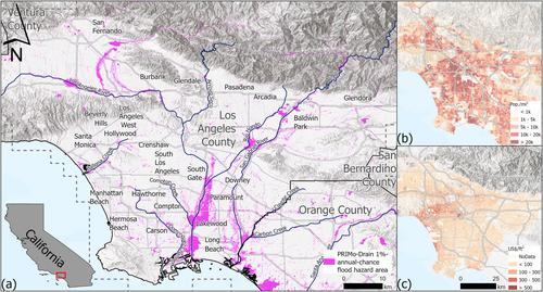
Extreme flooding events are becoming more frequent and costly, and impacts have been concentrated in cities where exposure and vulnerability are both heightened. To manage risks, governments, the private sector, and households now rely on flood hazard data from national-scale models that lack accuracy in urban areas due to unresolved drainage processes and infrastructure. Here we assess the uncertainties of First Street Foundation (FSF) flood hazard data, available across the U.S., using a new model (PRIMo-Drain) that resolves drainage infrastructure and fine resolution drainage dynamics. Using the case of Los Angeles, California, we find that FSF and PRIMo-Drain estimates of population and property value exposed to 1%- and 5%-annual-chance hazards diverge at finer scales of governance, for example, by 4- to 18-fold at the municipal scale. FSF and PRIMo-Drain data often predict opposite patterns of exposure inequality across social groups (e.g., Black, White, Disadvantaged). Further, at the county scale, we compute a Model Agreement Index of only 24%—a ∼1 in 4 chance of models agreeing upon which properties are at risk. Collectively, these differences point to limited capacity of FSF data to confidently assess which municipalities, social groups, and individual properties are at risk of flooding within urban areas. These results caution that national-scale model data at present may misinform urban flood risk strategies and lead to maladaptation, underscoring the importance of refined and validated urban models.
期刊介绍:
Earth’s Future: A transdisciplinary open access journal, Earth’s Future focuses on the state of the Earth and the prediction of the planet’s future. By publishing peer-reviewed articles as well as editorials, essays, reviews, and commentaries, this journal will be the preeminent scholarly resource on the Anthropocene. It will also help assess the risks and opportunities associated with environmental changes and challenges.


 分享
分享
 求助内容:
求助内容: 应助结果提醒方式:
 扫码关注我们
