{"title":"解读印度鲭 Rastrelliger kanagurta(Cuvier,1817 年)在印度西北海岸的分布情况","authors":"Sahina Akter, Ajay Nakhawa, Santosh Bhendekar, Dhanya M. Lal, Zeba Jaffer Abidi, Binaya Bhusan Nayak, Karankumar Ramteke","doi":"10.1007/s41208-024-00747-6","DOIUrl":null,"url":null,"abstract":"<p><i>Rastrelliger kanagurta</i> (Cuvier, 1817), commonly known as the Indian mackerel, is found widely across the coastlines of the Indian Ocean. This study explores the applicability of the Generalized Additive Model (GAM) for predicting the habitat preferences of the Indian mackerel. Data on Indian mackerel catch and oceanographic parameters were collected from January 2017 to April 2019. Parameters such as Sea Surface Temperature (SST), Chlorophyll-a concentration (CHL), Sea Surface Height (SSH), Sea Surface Salinity (SSS), Mixed Layer Depth (MLD), and Ocean Currents (OC) were sourced from the Copernicus Marine Environment Monitoring Service (CMEMS) satellites. Initial ggpairs plot analysis showed positive correlations between Indian mackerel abundance and SSH (<i>p</i> < 0.01, <i>r</i> = 0.19), and negative correlations with SSS (<i>p</i> < 0.01, <i>r</i> = -0.23) and OC (<i>p</i> < 0.05, <i>r</i> = -0.15). GAM results indicated that CHL (<i>p</i> < 0.001), SSS (<i>p</i> < 0.001), SSH (<i>p</i> < 0.001), SST (<i>p</i> < 0.001), and MLD (<i>p</i> < 0.05) significantly influence Indian mackerel catch along the Northwest coast of India. The distribution map revealed high abundance in the coastal waters of Mumbai and Raigad. GAM outputs were employed to generate a spatial prediction map, suggesting the potential for increased catches beyond 50 m depth compared to coastal areas. This study highlights the usefulness of multispectral satellite images in identifying potential fishing grounds. The findings from this research can aid decision-making, reduce fuel costs related to search and fishing operations, and enhance understanding of climate change effects on Indian mackerel distribution.</p>","PeriodicalId":22298,"journal":{"name":"Thalassas: An International Journal of Marine Sciences","volume":"11 1","pages":""},"PeriodicalIF":0.0000,"publicationDate":"2024-07-30","publicationTypes":"Journal Article","fieldsOfStudy":null,"isOpenAccess":false,"openAccessPdf":"","citationCount":"0","resultStr":"{\"title\":\"Deciphering the distribution of Indian mackerel, Rastrelliger kanagurta (Cuvier, 1817) along the Northwest coasts of India\",\"authors\":\"Sahina Akter, Ajay Nakhawa, Santosh Bhendekar, Dhanya M. Lal, Zeba Jaffer Abidi, Binaya Bhusan Nayak, Karankumar Ramteke\",\"doi\":\"10.1007/s41208-024-00747-6\",\"DOIUrl\":null,\"url\":null,\"abstract\":\"<p><i>Rastrelliger kanagurta</i> (Cuvier, 1817), commonly known as the Indian mackerel, is found widely across the coastlines of the Indian Ocean. This study explores the applicability of the Generalized Additive Model (GAM) for predicting the habitat preferences of the Indian mackerel. Data on Indian mackerel catch and oceanographic parameters were collected from January 2017 to April 2019. Parameters such as Sea Surface Temperature (SST), Chlorophyll-a concentration (CHL), Sea Surface Height (SSH), Sea Surface Salinity (SSS), Mixed Layer Depth (MLD), and Ocean Currents (OC) were sourced from the Copernicus Marine Environment Monitoring Service (CMEMS) satellites. Initial ggpairs plot analysis showed positive correlations between Indian mackerel abundance and SSH (<i>p</i> < 0.01, <i>r</i> = 0.19), and negative correlations with SSS (<i>p</i> < 0.01, <i>r</i> = -0.23) and OC (<i>p</i> < 0.05, <i>r</i> = -0.15). GAM results indicated that CHL (<i>p</i> < 0.001), SSS (<i>p</i> < 0.001), SSH (<i>p</i> < 0.001), SST (<i>p</i> < 0.001), and MLD (<i>p</i> < 0.05) significantly influence Indian mackerel catch along the Northwest coast of India. The distribution map revealed high abundance in the coastal waters of Mumbai and Raigad. GAM outputs were employed to generate a spatial prediction map, suggesting the potential for increased catches beyond 50 m depth compared to coastal areas. This study highlights the usefulness of multispectral satellite images in identifying potential fishing grounds. The findings from this research can aid decision-making, reduce fuel costs related to search and fishing operations, and enhance understanding of climate change effects on Indian mackerel distribution.</p>\",\"PeriodicalId\":22298,\"journal\":{\"name\":\"Thalassas: An International Journal of Marine Sciences\",\"volume\":\"11 1\",\"pages\":\"\"},\"PeriodicalIF\":0.0000,\"publicationDate\":\"2024-07-30\",\"publicationTypes\":\"Journal Article\",\"fieldsOfStudy\":null,\"isOpenAccess\":false,\"openAccessPdf\":\"\",\"citationCount\":\"0\",\"resultStr\":null,\"platform\":\"Semanticscholar\",\"paperid\":null,\"PeriodicalName\":\"Thalassas: An International Journal of Marine Sciences\",\"FirstCategoryId\":\"1085\",\"ListUrlMain\":\"https://doi.org/10.1007/s41208-024-00747-6\",\"RegionNum\":0,\"RegionCategory\":null,\"ArticlePicture\":[],\"TitleCN\":null,\"AbstractTextCN\":null,\"PMCID\":null,\"EPubDate\":\"\",\"PubModel\":\"\",\"JCR\":\"\",\"JCRName\":\"\",\"Score\":null,\"Total\":0}","platform":"Semanticscholar","paperid":null,"PeriodicalName":"Thalassas: An International Journal of Marine Sciences","FirstCategoryId":"1085","ListUrlMain":"https://doi.org/10.1007/s41208-024-00747-6","RegionNum":0,"RegionCategory":null,"ArticlePicture":[],"TitleCN":null,"AbstractTextCN":null,"PMCID":null,"EPubDate":"","PubModel":"","JCR":"","JCRName":"","Score":null,"Total":0}
Deciphering the distribution of Indian mackerel, Rastrelliger kanagurta (Cuvier, 1817) along the Northwest coasts of India
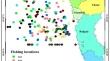
Rastrelliger kanagurta (Cuvier, 1817), commonly known as the Indian mackerel, is found widely across the coastlines of the Indian Ocean. This study explores the applicability of the Generalized Additive Model (GAM) for predicting the habitat preferences of the Indian mackerel. Data on Indian mackerel catch and oceanographic parameters were collected from January 2017 to April 2019. Parameters such as Sea Surface Temperature (SST), Chlorophyll-a concentration (CHL), Sea Surface Height (SSH), Sea Surface Salinity (SSS), Mixed Layer Depth (MLD), and Ocean Currents (OC) were sourced from the Copernicus Marine Environment Monitoring Service (CMEMS) satellites. Initial ggpairs plot analysis showed positive correlations between Indian mackerel abundance and SSH (p < 0.01, r = 0.19), and negative correlations with SSS (p < 0.01, r = -0.23) and OC (p < 0.05, r = -0.15). GAM results indicated that CHL (p < 0.001), SSS (p < 0.001), SSH (p < 0.001), SST (p < 0.001), and MLD (p < 0.05) significantly influence Indian mackerel catch along the Northwest coast of India. The distribution map revealed high abundance in the coastal waters of Mumbai and Raigad. GAM outputs were employed to generate a spatial prediction map, suggesting the potential for increased catches beyond 50 m depth compared to coastal areas. This study highlights the usefulness of multispectral satellite images in identifying potential fishing grounds. The findings from this research can aid decision-making, reduce fuel costs related to search and fishing operations, and enhance understanding of climate change effects on Indian mackerel distribution.


 分享
分享

 求助内容:
求助内容: 应助结果提醒方式:
 扫码关注我们
