Seyd Teymoor Seydi, John T. Abatzoglou, Amir AghaKouchak, Yavar Pourmohamad, Ashok Mishra, Mojtaba Sadegh
{"title":"利用物理信息机器学习预测了解植被与土壤烧伤严重程度之间的联系","authors":"Seyd Teymoor Seydi, John T. Abatzoglou, Amir AghaKouchak, Yavar Pourmohamad, Ashok Mishra, Mojtaba Sadegh","doi":"10.1029/2024EF004873","DOIUrl":null,"url":null,"abstract":"<p>Burn severity is fundamental to post-fire impact assessment and emergency response. Vegetation Burn Severity (VBS) can be derived from satellite observations. However, Soil Burn Severity (SBS) assessment—critical for mitigating hydrologic and geologic hazards—requires costly and laborious field recalibration of VBS maps. Here, we develop a physics-informed Machine Learning model capable of accurately estimating SBS while revealing the intricate relationships between soil and vegetation burn severities. Our SBS classification model uses VBS, as well as climatological, meteorological, ecological, geological, and topographical wildfire covariates. This model demonstrated an overall accuracy of 89% for out-of-sample test data. The model exhibited scalability with additional data, and was able to extract universal functional relationships between vegetation and soil burn severities across the western US. VBS had the largest control on SBS, followed by weather (e.g., wind, fire danger, temperature), climate (e.g., annual precipitation), topography (e.g., elevation), and soil characteristics (e.g., soil organic carbon content). The relative control of processes on SBS changes across regions. Our model revealed nuanced relationships between VBS and SBS; for example, a similar VBS with lower wind speeds—that is, higher fire residence time—translates to a higher SBS. This transferrable model develops reliable and timely SBS maps using satellite and publicly accessible data, providing science-based insights for managers and diverse stakeholders.</p>","PeriodicalId":48748,"journal":{"name":"Earths Future","volume":"12 8","pages":""},"PeriodicalIF":8.2000,"publicationDate":"2024-08-13","publicationTypes":"Journal Article","fieldsOfStudy":null,"isOpenAccess":false,"openAccessPdf":"https://onlinelibrary.wiley.com/doi/epdf/10.1029/2024EF004873","citationCount":"0","resultStr":"{\"title\":\"Predictive Understanding of Links Between Vegetation and Soil Burn Severities Using Physics-Informed Machine Learning\",\"authors\":\"Seyd Teymoor Seydi, John T. Abatzoglou, Amir AghaKouchak, Yavar Pourmohamad, Ashok Mishra, Mojtaba Sadegh\",\"doi\":\"10.1029/2024EF004873\",\"DOIUrl\":null,\"url\":null,\"abstract\":\"<p>Burn severity is fundamental to post-fire impact assessment and emergency response. Vegetation Burn Severity (VBS) can be derived from satellite observations. However, Soil Burn Severity (SBS) assessment—critical for mitigating hydrologic and geologic hazards—requires costly and laborious field recalibration of VBS maps. Here, we develop a physics-informed Machine Learning model capable of accurately estimating SBS while revealing the intricate relationships between soil and vegetation burn severities. Our SBS classification model uses VBS, as well as climatological, meteorological, ecological, geological, and topographical wildfire covariates. This model demonstrated an overall accuracy of 89% for out-of-sample test data. The model exhibited scalability with additional data, and was able to extract universal functional relationships between vegetation and soil burn severities across the western US. VBS had the largest control on SBS, followed by weather (e.g., wind, fire danger, temperature), climate (e.g., annual precipitation), topography (e.g., elevation), and soil characteristics (e.g., soil organic carbon content). The relative control of processes on SBS changes across regions. Our model revealed nuanced relationships between VBS and SBS; for example, a similar VBS with lower wind speeds—that is, higher fire residence time—translates to a higher SBS. This transferrable model develops reliable and timely SBS maps using satellite and publicly accessible data, providing science-based insights for managers and diverse stakeholders.</p>\",\"PeriodicalId\":48748,\"journal\":{\"name\":\"Earths Future\",\"volume\":\"12 8\",\"pages\":\"\"},\"PeriodicalIF\":8.2000,\"publicationDate\":\"2024-08-13\",\"publicationTypes\":\"Journal Article\",\"fieldsOfStudy\":null,\"isOpenAccess\":false,\"openAccessPdf\":\"https://onlinelibrary.wiley.com/doi/epdf/10.1029/2024EF004873\",\"citationCount\":\"0\",\"resultStr\":null,\"platform\":\"Semanticscholar\",\"paperid\":null,\"PeriodicalName\":\"Earths Future\",\"FirstCategoryId\":\"89\",\"ListUrlMain\":\"https://agupubs.onlinelibrary.wiley.com/doi/10.1029/2024EF004873\",\"RegionNum\":1,\"RegionCategory\":\"地球科学\",\"ArticlePicture\":[],\"TitleCN\":null,\"AbstractTextCN\":null,\"PMCID\":null,\"EPubDate\":\"\",\"PubModel\":\"\",\"JCR\":\"Q1\",\"JCRName\":\"ENVIRONMENTAL SCIENCES\",\"Score\":null,\"Total\":0}","platform":"Semanticscholar","paperid":null,"PeriodicalName":"Earths Future","FirstCategoryId":"89","ListUrlMain":"https://agupubs.onlinelibrary.wiley.com/doi/10.1029/2024EF004873","RegionNum":1,"RegionCategory":"地球科学","ArticlePicture":[],"TitleCN":null,"AbstractTextCN":null,"PMCID":null,"EPubDate":"","PubModel":"","JCR":"Q1","JCRName":"ENVIRONMENTAL SCIENCES","Score":null,"Total":0}
引用次数: 0
摘要
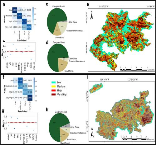
燃烧严重程度是火后影响评估和应急响应的基础。植被烧伤严重程度(VBS)可通过卫星观测得出。然而,土壤燃烧严重度(SBS)评估--对于减轻水文和地质灾害至关重要--需要对 VBS 地图进行昂贵而费力的实地重新校准。在此,我们开发了一种物理信息机器学习模型,该模型能够准确估计 SBS,同时揭示土壤和植被燃烧严重程度之间错综复杂的关系。我们的 SBS 分类模型使用了 VBS 以及气候、气象、生态、地质和地形野火协变量。该模型在样本外测试数据中的总体准确率为 89%。该模型具有可扩展性,可使用更多数据,并能提取美国西部植被和土壤燃烧严重程度之间的普遍函数关系。VBS 对 SBS 的控制作用最大,其次是天气(如风、火险、温度)、气候(如年降水量)、地形(如海拔)和土壤特性(如土壤有机碳含量)。各过程对 SBS 的相对控制在不同地区有所变化。我们的模型揭示了 VBS 与 SBS 之间的细微关系;例如,风速较低的相似 VBS(即较高的火停留时间)会转化为较高的 SBS。这一可移植模型利用卫星数据和可公开获取的数据绘制了可靠、及时的 SBS 地图,为管理人员和不同的利益相关者提供了以科学为基础的见解。
Predictive Understanding of Links Between Vegetation and Soil Burn Severities Using Physics-Informed Machine Learning
Burn severity is fundamental to post-fire impact assessment and emergency response. Vegetation Burn Severity (VBS) can be derived from satellite observations. However, Soil Burn Severity (SBS) assessment—critical for mitigating hydrologic and geologic hazards—requires costly and laborious field recalibration of VBS maps. Here, we develop a physics-informed Machine Learning model capable of accurately estimating SBS while revealing the intricate relationships between soil and vegetation burn severities. Our SBS classification model uses VBS, as well as climatological, meteorological, ecological, geological, and topographical wildfire covariates. This model demonstrated an overall accuracy of 89% for out-of-sample test data. The model exhibited scalability with additional data, and was able to extract universal functional relationships between vegetation and soil burn severities across the western US. VBS had the largest control on SBS, followed by weather (e.g., wind, fire danger, temperature), climate (e.g., annual precipitation), topography (e.g., elevation), and soil characteristics (e.g., soil organic carbon content). The relative control of processes on SBS changes across regions. Our model revealed nuanced relationships between VBS and SBS; for example, a similar VBS with lower wind speeds—that is, higher fire residence time—translates to a higher SBS. This transferrable model develops reliable and timely SBS maps using satellite and publicly accessible data, providing science-based insights for managers and diverse stakeholders.
期刊介绍:
Earth’s Future: A transdisciplinary open access journal, Earth’s Future focuses on the state of the Earth and the prediction of the planet’s future. By publishing peer-reviewed articles as well as editorials, essays, reviews, and commentaries, this journal will be the preeminent scholarly resource on the Anthropocene. It will also help assess the risks and opportunities associated with environmental changes and challenges.


 分享
分享
 求助内容:
求助内容: 应助结果提醒方式:
 扫码关注我们
