{"title":"用于河流监测和水动力模型校准的多任务虚拟监测站","authors":"Debi Prasad Sahoo , Bhabagrahi Sahoo , Manoj Kumar Tiwari , Kunwar Abhishek Singh , Angelica Tarpanelli","doi":"10.1016/j.rsase.2024.101330","DOIUrl":null,"url":null,"abstract":"<div><p>A comprehensive understanding of the streamflow dynamic along the river system is one of the significant components for preserving biodiversity and ensuring sustainable ecological processes. Understanding this requirement, streamflow estimation using remote sensing (RS) has evolved as an alternate approach in the hydrologic literature during the last decade due to its extensive spatiotemporal coverage. However, the existing RS-based approaches have limited applications for deriving the continuous time series in tropical river reaches due to narrow water widths during the low flow and frequent cloud covers during the high flow periods. Therefore, this study proposed frameworks to establish a virtual monitoring station (VMS) where multi-mission satellites are being used to derive continuous streamflow time series. From the multi-mission satellites, the optical RS images are used to develop a Copula-based fusion (CFUS) model by integrating the Frank copula with the 30m × 1-day resolution synthetic Landsat images, derived from the fusion of 250m × 1-day resolution MODIS images and 30m × 16-days resolution Landsat images; whereas the water levels are retrieved from the altimeters to derive discharge using the rating curve. Additionally, the potential utility of the established VMS for hydrodynamic model (MIKE11-NAM-HD) calibration under data-scarce conditions is also demonstrated. Finally, a coupled RS-hydrodynamic (RS-HD) framework is also proposed to establish VMS both at semi-gauged and ungauged sections of the rivers. The efficacy of the aforementioned framework was tested along the lower Brahmani river reach. The results reveal that the advocated framework could perform satisfactorily with the Nash-Sutcliffe efficiency (NSE) and Kling-Gupta efficiency (KGE) ≥0.8. This approach has the potential to be upscaled to other river reaches as one of the next-generation hydrometry for daily streamflow monitoring using high-frequent observation of multi-mission satellites.</p></div>","PeriodicalId":53227,"journal":{"name":"Remote Sensing Applications-Society and Environment","volume":"36 ","pages":"Article 101330"},"PeriodicalIF":4.5000,"publicationDate":"2024-11-01","publicationTypes":"Journal Article","fieldsOfStudy":null,"isOpenAccess":false,"openAccessPdf":"","citationCount":"0","resultStr":"{\"title\":\"Multi-mission virtual monitoring station for streamflow monitoring and hydrodynamic model calibration\",\"authors\":\"Debi Prasad Sahoo , Bhabagrahi Sahoo , Manoj Kumar Tiwari , Kunwar Abhishek Singh , Angelica Tarpanelli\",\"doi\":\"10.1016/j.rsase.2024.101330\",\"DOIUrl\":null,\"url\":null,\"abstract\":\"<div><p>A comprehensive understanding of the streamflow dynamic along the river system is one of the significant components for preserving biodiversity and ensuring sustainable ecological processes. Understanding this requirement, streamflow estimation using remote sensing (RS) has evolved as an alternate approach in the hydrologic literature during the last decade due to its extensive spatiotemporal coverage. However, the existing RS-based approaches have limited applications for deriving the continuous time series in tropical river reaches due to narrow water widths during the low flow and frequent cloud covers during the high flow periods. Therefore, this study proposed frameworks to establish a virtual monitoring station (VMS) where multi-mission satellites are being used to derive continuous streamflow time series. From the multi-mission satellites, the optical RS images are used to develop a Copula-based fusion (CFUS) model by integrating the Frank copula with the 30m × 1-day resolution synthetic Landsat images, derived from the fusion of 250m × 1-day resolution MODIS images and 30m × 16-days resolution Landsat images; whereas the water levels are retrieved from the altimeters to derive discharge using the rating curve. Additionally, the potential utility of the established VMS for hydrodynamic model (MIKE11-NAM-HD) calibration under data-scarce conditions is also demonstrated. Finally, a coupled RS-hydrodynamic (RS-HD) framework is also proposed to establish VMS both at semi-gauged and ungauged sections of the rivers. The efficacy of the aforementioned framework was tested along the lower Brahmani river reach. The results reveal that the advocated framework could perform satisfactorily with the Nash-Sutcliffe efficiency (NSE) and Kling-Gupta efficiency (KGE) ≥0.8. This approach has the potential to be upscaled to other river reaches as one of the next-generation hydrometry for daily streamflow monitoring using high-frequent observation of multi-mission satellites.</p></div>\",\"PeriodicalId\":53227,\"journal\":{\"name\":\"Remote Sensing Applications-Society and Environment\",\"volume\":\"36 \",\"pages\":\"Article 101330\"},\"PeriodicalIF\":4.5000,\"publicationDate\":\"2024-11-01\",\"publicationTypes\":\"Journal Article\",\"fieldsOfStudy\":null,\"isOpenAccess\":false,\"openAccessPdf\":\"\",\"citationCount\":\"0\",\"resultStr\":null,\"platform\":\"Semanticscholar\",\"paperid\":null,\"PeriodicalName\":\"Remote Sensing Applications-Society and Environment\",\"FirstCategoryId\":\"1085\",\"ListUrlMain\":\"https://www.sciencedirect.com/science/article/pii/S2352938524001940\",\"RegionNum\":0,\"RegionCategory\":null,\"ArticlePicture\":[],\"TitleCN\":null,\"AbstractTextCN\":null,\"PMCID\":null,\"EPubDate\":\"2024/8/22 0:00:00\",\"PubModel\":\"Epub\",\"JCR\":\"Q2\",\"JCRName\":\"ENVIRONMENTAL SCIENCES\",\"Score\":null,\"Total\":0}","platform":"Semanticscholar","paperid":null,"PeriodicalName":"Remote Sensing Applications-Society and Environment","FirstCategoryId":"1085","ListUrlMain":"https://www.sciencedirect.com/science/article/pii/S2352938524001940","RegionNum":0,"RegionCategory":null,"ArticlePicture":[],"TitleCN":null,"AbstractTextCN":null,"PMCID":null,"EPubDate":"2024/8/22 0:00:00","PubModel":"Epub","JCR":"Q2","JCRName":"ENVIRONMENTAL SCIENCES","Score":null,"Total":0}
Multi-mission virtual monitoring station for streamflow monitoring and hydrodynamic model calibration
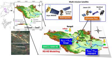
A comprehensive understanding of the streamflow dynamic along the river system is one of the significant components for preserving biodiversity and ensuring sustainable ecological processes. Understanding this requirement, streamflow estimation using remote sensing (RS) has evolved as an alternate approach in the hydrologic literature during the last decade due to its extensive spatiotemporal coverage. However, the existing RS-based approaches have limited applications for deriving the continuous time series in tropical river reaches due to narrow water widths during the low flow and frequent cloud covers during the high flow periods. Therefore, this study proposed frameworks to establish a virtual monitoring station (VMS) where multi-mission satellites are being used to derive continuous streamflow time series. From the multi-mission satellites, the optical RS images are used to develop a Copula-based fusion (CFUS) model by integrating the Frank copula with the 30m × 1-day resolution synthetic Landsat images, derived from the fusion of 250m × 1-day resolution MODIS images and 30m × 16-days resolution Landsat images; whereas the water levels are retrieved from the altimeters to derive discharge using the rating curve. Additionally, the potential utility of the established VMS for hydrodynamic model (MIKE11-NAM-HD) calibration under data-scarce conditions is also demonstrated. Finally, a coupled RS-hydrodynamic (RS-HD) framework is also proposed to establish VMS both at semi-gauged and ungauged sections of the rivers. The efficacy of the aforementioned framework was tested along the lower Brahmani river reach. The results reveal that the advocated framework could perform satisfactorily with the Nash-Sutcliffe efficiency (NSE) and Kling-Gupta efficiency (KGE) ≥0.8. This approach has the potential to be upscaled to other river reaches as one of the next-generation hydrometry for daily streamflow monitoring using high-frequent observation of multi-mission satellites.
期刊介绍:
The journal ''Remote Sensing Applications: Society and Environment'' (RSASE) focuses on remote sensing studies that address specific topics with an emphasis on environmental and societal issues - regional / local studies with global significance. Subjects are encouraged to have an interdisciplinary approach and include, but are not limited by: " -Global and climate change studies addressing the impact of increasing concentrations of greenhouse gases, CO2 emission, carbon balance and carbon mitigation, energy system on social and environmental systems -Ecological and environmental issues including biodiversity, ecosystem dynamics, land degradation, atmospheric and water pollution, urban footprint, ecosystem management and natural hazards (e.g. earthquakes, typhoons, floods, landslides) -Natural resource studies including land-use in general, biomass estimation, forests, agricultural land, plantation, soils, coral reefs, wetland and water resources -Agriculture, food production systems and food security outcomes -Socio-economic issues including urban systems, urban growth, public health, epidemics, land-use transition and land use conflicts -Oceanography and coastal zone studies, including sea level rise projections, coastlines changes and the ocean-land interface -Regional challenges for remote sensing application techniques, monitoring and analysis, such as cloud screening and atmospheric correction for tropical regions -Interdisciplinary studies combining remote sensing, household survey data, field measurements and models to address environmental, societal and sustainability issues -Quantitative and qualitative analysis that documents the impact of using remote sensing studies in social, political, environmental or economic systems


 分享
分享

 求助内容:
求助内容: 应助结果提醒方式:
 扫码关注我们
