Xuelei Zhang , Hu Yang , Chunhua Liu , Qingqing Tong , Aijun Xiu , Lingsheng Kong , Mo Dan , Chao Gao , Meng Gao , Huizheng Che , Xin Wang , Guangjian Wu
{"title":"基于 XR 的交互式可视化平台,用于实时探索动态地球科学数据","authors":"Xuelei Zhang , Hu Yang , Chunhua Liu , Qingqing Tong , Aijun Xiu , Lingsheng Kong , Mo Dan , Chao Gao , Meng Gao , Huizheng Che , Xin Wang , Guangjian Wu","doi":"10.1016/j.envsoft.2024.106193","DOIUrl":null,"url":null,"abstract":"<div><p>The transition from 2D planar displays to immersive holographic 3D environments has brought advancements in visualization technology. However, there remains a lack of effective interactive visualization tools for complex multi-dimensional structured or unstructured datasets in immersive space. To address this gap, we have developed MetIVA, a state-of-the-art multiscale interactive data visualization platform that leverages the Extended Reality (XR) and cloud rendering technology for immersive data exploration. In this paper, we firstly outline the historical development of scientific visualization and the recent shift towards 3D and higher-dimensional visualization, and then basically introduce the conceptual framework and platform structure of MetIVA, and finally present the evaluation results from recruited potential users. The results confirm that MetIVA is a powerful tool to accelerate data exploration and decision-making processes. Its interactive and intuitive features, along with ongoing optimization efforts, make it a valuable tool for researchers and practitioners in the field of Earth science.</p></div>","PeriodicalId":310,"journal":{"name":"Environmental Modelling & Software","volume":"183 ","pages":"Article 106193"},"PeriodicalIF":5.2000,"publicationDate":"2025-01-01","publicationTypes":"Journal Article","fieldsOfStudy":null,"isOpenAccess":false,"openAccessPdf":"","citationCount":"0","resultStr":"{\"title\":\"XR-based interactive visualization platform for real-time exploring dynamic earth science data\",\"authors\":\"Xuelei Zhang , Hu Yang , Chunhua Liu , Qingqing Tong , Aijun Xiu , Lingsheng Kong , Mo Dan , Chao Gao , Meng Gao , Huizheng Che , Xin Wang , Guangjian Wu\",\"doi\":\"10.1016/j.envsoft.2024.106193\",\"DOIUrl\":null,\"url\":null,\"abstract\":\"<div><p>The transition from 2D planar displays to immersive holographic 3D environments has brought advancements in visualization technology. However, there remains a lack of effective interactive visualization tools for complex multi-dimensional structured or unstructured datasets in immersive space. To address this gap, we have developed MetIVA, a state-of-the-art multiscale interactive data visualization platform that leverages the Extended Reality (XR) and cloud rendering technology for immersive data exploration. In this paper, we firstly outline the historical development of scientific visualization and the recent shift towards 3D and higher-dimensional visualization, and then basically introduce the conceptual framework and platform structure of MetIVA, and finally present the evaluation results from recruited potential users. The results confirm that MetIVA is a powerful tool to accelerate data exploration and decision-making processes. Its interactive and intuitive features, along with ongoing optimization efforts, make it a valuable tool for researchers and practitioners in the field of Earth science.</p></div>\",\"PeriodicalId\":310,\"journal\":{\"name\":\"Environmental Modelling & Software\",\"volume\":\"183 \",\"pages\":\"Article 106193\"},\"PeriodicalIF\":5.2000,\"publicationDate\":\"2025-01-01\",\"publicationTypes\":\"Journal Article\",\"fieldsOfStudy\":null,\"isOpenAccess\":false,\"openAccessPdf\":\"\",\"citationCount\":\"0\",\"resultStr\":null,\"platform\":\"Semanticscholar\",\"paperid\":null,\"PeriodicalName\":\"Environmental Modelling & Software\",\"FirstCategoryId\":\"93\",\"ListUrlMain\":\"https://www.sciencedirect.com/science/article/pii/S1364815224002548\",\"RegionNum\":2,\"RegionCategory\":\"环境科学与生态学\",\"ArticlePicture\":[],\"TitleCN\":null,\"AbstractTextCN\":null,\"PMCID\":null,\"EPubDate\":\"2024/8/29 0:00:00\",\"PubModel\":\"Epub\",\"JCR\":\"Q1\",\"JCRName\":\"COMPUTER SCIENCE, INTERDISCIPLINARY APPLICATIONS\",\"Score\":null,\"Total\":0}","platform":"Semanticscholar","paperid":null,"PeriodicalName":"Environmental Modelling & Software","FirstCategoryId":"93","ListUrlMain":"https://www.sciencedirect.com/science/article/pii/S1364815224002548","RegionNum":2,"RegionCategory":"环境科学与生态学","ArticlePicture":[],"TitleCN":null,"AbstractTextCN":null,"PMCID":null,"EPubDate":"2024/8/29 0:00:00","PubModel":"Epub","JCR":"Q1","JCRName":"COMPUTER SCIENCE, INTERDISCIPLINARY APPLICATIONS","Score":null,"Total":0}
XR-based interactive visualization platform for real-time exploring dynamic earth science data
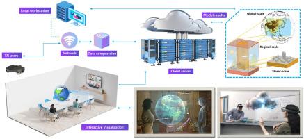
The transition from 2D planar displays to immersive holographic 3D environments has brought advancements in visualization technology. However, there remains a lack of effective interactive visualization tools for complex multi-dimensional structured or unstructured datasets in immersive space. To address this gap, we have developed MetIVA, a state-of-the-art multiscale interactive data visualization platform that leverages the Extended Reality (XR) and cloud rendering technology for immersive data exploration. In this paper, we firstly outline the historical development of scientific visualization and the recent shift towards 3D and higher-dimensional visualization, and then basically introduce the conceptual framework and platform structure of MetIVA, and finally present the evaluation results from recruited potential users. The results confirm that MetIVA is a powerful tool to accelerate data exploration and decision-making processes. Its interactive and intuitive features, along with ongoing optimization efforts, make it a valuable tool for researchers and practitioners in the field of Earth science.
期刊介绍:
Environmental Modelling & Software publishes contributions, in the form of research articles, reviews and short communications, on recent advances in environmental modelling and/or software. The aim is to improve our capacity to represent, understand, predict or manage the behaviour of environmental systems at all practical scales, and to communicate those improvements to a wide scientific and professional audience.


 分享
分享
 求助内容:
求助内容: 应助结果提醒方式:
 扫码关注我们
