Hilal Adıyaman, Yunus Emre Varul, Tolga Bakırman, Bülent Bayram
{"title":"利用深度学习对 Landsat-7 进行条纹误差校正","authors":"Hilal Adıyaman, Yunus Emre Varul, Tolga Bakırman, Bülent Bayram","doi":"10.1007/s41064-024-00306-x","DOIUrl":null,"url":null,"abstract":"<p>Long-term time series satellite imagery became highly essential for analyzing earth cycles such as global warming, climate change, and urbanization. Landsat‑7 satellite imagery plays a key role in this domain since it provides open-access data with expansive coverage and consistent temporal resolution for more than two decades. This paper addresses the challenge of stripe errors induced by Scan Line Corrector sensor malfunction in Landsat‑7 ETM+ satellite imagery, resulting in data loss and degradation. To overcome this problem, we propose a Generative Adversarial Networks approach to fill the gaps in the Landsat‑7 ETM+ panchromatic images. First, we introduce the YTU_STRIPE dataset, comprising Landsat‑8 OLI panchromatic images with synthetically induced stripe errors, for model training and testing. Our results indicate sufficient performance of the Pix2Pix GAN for this purpose. We demonstrate the efficiency of our approach through systematic experimentation and evaluation using various accuracy metrics, including Peak Signal-to-Noise Ratio, Structural Similarity Index Measurement, Universal Image Quality Index, Correlation Coefficient, and Root Mean Square Error which were calculated as 38.5570, 0.9206, 0.7670, 0.7753 and 3.8212, respectively. Our findings suggest promising prospects for utilizing synthetic imagery from Landsat‑8 OLI to mitigate stripe errors in Landsat‑7 ETM+ SLC-off imagery, thereby enhancing image reconstruction efforts. The datasets and model weights generated in this study are publicly available for further research and development: https://github.com/ynsemrevrl/eliminating-stripe-errors.</p>","PeriodicalId":56035,"journal":{"name":"PFG-Journal of Photogrammetry Remote Sensing and Geoinformation Science","volume":"14 1","pages":""},"PeriodicalIF":2.1000,"publicationDate":"2024-08-29","publicationTypes":"Journal Article","fieldsOfStudy":null,"isOpenAccess":false,"openAccessPdf":"","citationCount":"0","resultStr":"{\"title\":\"Stripe Error Correction for Landsat-7 Using Deep Learning\",\"authors\":\"Hilal Adıyaman, Yunus Emre Varul, Tolga Bakırman, Bülent Bayram\",\"doi\":\"10.1007/s41064-024-00306-x\",\"DOIUrl\":null,\"url\":null,\"abstract\":\"<p>Long-term time series satellite imagery became highly essential for analyzing earth cycles such as global warming, climate change, and urbanization. Landsat‑7 satellite imagery plays a key role in this domain since it provides open-access data with expansive coverage and consistent temporal resolution for more than two decades. This paper addresses the challenge of stripe errors induced by Scan Line Corrector sensor malfunction in Landsat‑7 ETM+ satellite imagery, resulting in data loss and degradation. To overcome this problem, we propose a Generative Adversarial Networks approach to fill the gaps in the Landsat‑7 ETM+ panchromatic images. First, we introduce the YTU_STRIPE dataset, comprising Landsat‑8 OLI panchromatic images with synthetically induced stripe errors, for model training and testing. Our results indicate sufficient performance of the Pix2Pix GAN for this purpose. We demonstrate the efficiency of our approach through systematic experimentation and evaluation using various accuracy metrics, including Peak Signal-to-Noise Ratio, Structural Similarity Index Measurement, Universal Image Quality Index, Correlation Coefficient, and Root Mean Square Error which were calculated as 38.5570, 0.9206, 0.7670, 0.7753 and 3.8212, respectively. Our findings suggest promising prospects for utilizing synthetic imagery from Landsat‑8 OLI to mitigate stripe errors in Landsat‑7 ETM+ SLC-off imagery, thereby enhancing image reconstruction efforts. The datasets and model weights generated in this study are publicly available for further research and development: https://github.com/ynsemrevrl/eliminating-stripe-errors.</p>\",\"PeriodicalId\":56035,\"journal\":{\"name\":\"PFG-Journal of Photogrammetry Remote Sensing and Geoinformation Science\",\"volume\":\"14 1\",\"pages\":\"\"},\"PeriodicalIF\":2.1000,\"publicationDate\":\"2024-08-29\",\"publicationTypes\":\"Journal Article\",\"fieldsOfStudy\":null,\"isOpenAccess\":false,\"openAccessPdf\":\"\",\"citationCount\":\"0\",\"resultStr\":null,\"platform\":\"Semanticscholar\",\"paperid\":null,\"PeriodicalName\":\"PFG-Journal of Photogrammetry Remote Sensing and Geoinformation Science\",\"FirstCategoryId\":\"89\",\"ListUrlMain\":\"https://doi.org/10.1007/s41064-024-00306-x\",\"RegionNum\":4,\"RegionCategory\":\"地球科学\",\"ArticlePicture\":[],\"TitleCN\":null,\"AbstractTextCN\":null,\"PMCID\":null,\"EPubDate\":\"\",\"PubModel\":\"\",\"JCR\":\"Q3\",\"JCRName\":\"IMAGING SCIENCE & PHOTOGRAPHIC TECHNOLOGY\",\"Score\":null,\"Total\":0}","platform":"Semanticscholar","paperid":null,"PeriodicalName":"PFG-Journal of Photogrammetry Remote Sensing and Geoinformation Science","FirstCategoryId":"89","ListUrlMain":"https://doi.org/10.1007/s41064-024-00306-x","RegionNum":4,"RegionCategory":"地球科学","ArticlePicture":[],"TitleCN":null,"AbstractTextCN":null,"PMCID":null,"EPubDate":"","PubModel":"","JCR":"Q3","JCRName":"IMAGING SCIENCE & PHOTOGRAPHIC TECHNOLOGY","Score":null,"Total":0}
引用次数: 0
摘要
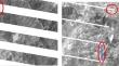
长期的时间序列卫星图像对于分析全球变暖、气候变化和城市化等地球周期非常重要。Landsat-7 卫星图像在这一领域发挥着关键作用,因为它提供了二十多年来覆盖范围广、时间分辨率一致的开放式数据。本文探讨了 Landsat-7 ETM+ 卫星图像中因扫描线校正器传感器故障而引起的条纹错误,从而导致数据丢失和质量下降的难题。为了克服这一问题,我们提出了一种生成对抗网络方法来填补 Landsat-7 ETM+ 全色图像中的空白。首先,我们引入了 YTU_STRIPE 数据集,该数据集由具有合成条纹误差的 Landsat-8 OLI 全色图像组成,用于模型训练和测试。我们的结果表明,Pix2Pix GAN 在这方面具有足够的性能。我们通过系统实验和使用各种精度指标(包括峰值信噪比、结构相似性指数测量、通用图像质量指数、相关系数和均方根误差)进行评估,证明了我们方法的效率,计算结果分别为 38.5570、0.9206、0.7670、0.7753 和 3.8212。我们的研究结果表明,利用来自 Landsat-8 OLI 的合成图像来减少 Landsat-7 ETM+ SLC-off 图像中的条纹误差,从而提高图像重建工作的效率,前景十分广阔。本研究生成的数据集和模型权重可公开用于进一步的研究和开发:https://github.com/ynsemrevrl/eliminating-stripe-errors。
Stripe Error Correction for Landsat-7 Using Deep Learning
Long-term time series satellite imagery became highly essential for analyzing earth cycles such as global warming, climate change, and urbanization. Landsat‑7 satellite imagery plays a key role in this domain since it provides open-access data with expansive coverage and consistent temporal resolution for more than two decades. This paper addresses the challenge of stripe errors induced by Scan Line Corrector sensor malfunction in Landsat‑7 ETM+ satellite imagery, resulting in data loss and degradation. To overcome this problem, we propose a Generative Adversarial Networks approach to fill the gaps in the Landsat‑7 ETM+ panchromatic images. First, we introduce the YTU_STRIPE dataset, comprising Landsat‑8 OLI panchromatic images with synthetically induced stripe errors, for model training and testing. Our results indicate sufficient performance of the Pix2Pix GAN for this purpose. We demonstrate the efficiency of our approach through systematic experimentation and evaluation using various accuracy metrics, including Peak Signal-to-Noise Ratio, Structural Similarity Index Measurement, Universal Image Quality Index, Correlation Coefficient, and Root Mean Square Error which were calculated as 38.5570, 0.9206, 0.7670, 0.7753 and 3.8212, respectively. Our findings suggest promising prospects for utilizing synthetic imagery from Landsat‑8 OLI to mitigate stripe errors in Landsat‑7 ETM+ SLC-off imagery, thereby enhancing image reconstruction efforts. The datasets and model weights generated in this study are publicly available for further research and development: https://github.com/ynsemrevrl/eliminating-stripe-errors.
期刊介绍:
PFG is an international scholarly journal covering the progress and application of photogrammetric methods, remote sensing technology and the interconnected field of geoinformation science. It places special editorial emphasis on the communication of new methodologies in data acquisition and new approaches to optimized processing and interpretation of all types of data which were acquired by photogrammetric methods, remote sensing, image processing and the computer-aided interpretation of such data in general. The journal hence addresses both researchers and students of these disciplines at academic institutions and universities as well as the downstream users in both the private sector and public administration.
Founded in 1926 under the former name Bildmessung und Luftbildwesen, PFG is worldwide the oldest journal on photogrammetry. It is the official journal of the German Society for Photogrammetry, Remote Sensing and Geoinformation (DGPF).


 分享
分享
 求助内容:
求助内容: 应助结果提醒方式:
 扫码关注我们
