James Finnis, Helen C. Miles, Ariel Ladegaard, Matt Gunn
{"title":"用于多光谱图像处理的开源工具包","authors":"James Finnis, Helen C. Miles, Ariel Ladegaard, Matt Gunn","doi":"10.1002/gdj3.283","DOIUrl":null,"url":null,"abstract":"<p>PCOT is a Python program and library which allows users to manipulate multispectral images and associated data. It is in active development in support of the ExoMars mission and intended to be used on data from the Rosalind Franklin rover, but it has much greater potential for use beyond this specific context. PCOT operates on a graph model – the data are processed through a set of nodes which manipulate it in various ways (e.g. add regions of interest, perform maths, splice images together, merge image channels, plot spectra). A PCOT document describes this graph, and we intend that documents are distributed along with the data they generate to help reproducibility. PCOT is open-source, and contributions can be made to the core software, as plugins, or by using PCOT as a library in your own code.</p>","PeriodicalId":54351,"journal":{"name":"Geoscience Data Journal","volume":"12 1","pages":""},"PeriodicalIF":2.4000,"publicationDate":"2024-12-03","publicationTypes":"Journal Article","fieldsOfStudy":null,"isOpenAccess":false,"openAccessPdf":"https://onlinelibrary.wiley.com/doi/epdf/10.1002/gdj3.283","citationCount":"0","resultStr":"{\"title\":\"PCOT: An open-source toolkit for multispectral image processing\",\"authors\":\"James Finnis, Helen C. Miles, Ariel Ladegaard, Matt Gunn\",\"doi\":\"10.1002/gdj3.283\",\"DOIUrl\":null,\"url\":null,\"abstract\":\"<p>PCOT is a Python program and library which allows users to manipulate multispectral images and associated data. It is in active development in support of the ExoMars mission and intended to be used on data from the Rosalind Franklin rover, but it has much greater potential for use beyond this specific context. PCOT operates on a graph model – the data are processed through a set of nodes which manipulate it in various ways (e.g. add regions of interest, perform maths, splice images together, merge image channels, plot spectra). A PCOT document describes this graph, and we intend that documents are distributed along with the data they generate to help reproducibility. PCOT is open-source, and contributions can be made to the core software, as plugins, or by using PCOT as a library in your own code.</p>\",\"PeriodicalId\":54351,\"journal\":{\"name\":\"Geoscience Data Journal\",\"volume\":\"12 1\",\"pages\":\"\"},\"PeriodicalIF\":2.4000,\"publicationDate\":\"2024-12-03\",\"publicationTypes\":\"Journal Article\",\"fieldsOfStudy\":null,\"isOpenAccess\":false,\"openAccessPdf\":\"https://onlinelibrary.wiley.com/doi/epdf/10.1002/gdj3.283\",\"citationCount\":\"0\",\"resultStr\":null,\"platform\":\"Semanticscholar\",\"paperid\":null,\"PeriodicalName\":\"Geoscience Data Journal\",\"FirstCategoryId\":\"89\",\"ListUrlMain\":\"https://rmets.onlinelibrary.wiley.com/doi/10.1002/gdj3.283\",\"RegionNum\":3,\"RegionCategory\":\"地球科学\",\"ArticlePicture\":[],\"TitleCN\":null,\"AbstractTextCN\":null,\"PMCID\":null,\"EPubDate\":\"\",\"PubModel\":\"\",\"JCR\":\"Q2\",\"JCRName\":\"GEOSCIENCES, MULTIDISCIPLINARY\",\"Score\":null,\"Total\":0}","platform":"Semanticscholar","paperid":null,"PeriodicalName":"Geoscience Data Journal","FirstCategoryId":"89","ListUrlMain":"https://rmets.onlinelibrary.wiley.com/doi/10.1002/gdj3.283","RegionNum":3,"RegionCategory":"地球科学","ArticlePicture":[],"TitleCN":null,"AbstractTextCN":null,"PMCID":null,"EPubDate":"","PubModel":"","JCR":"Q2","JCRName":"GEOSCIENCES, MULTIDISCIPLINARY","Score":null,"Total":0}
PCOT: An open-source toolkit for multispectral image processing
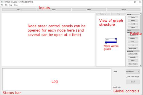
PCOT is a Python program and library which allows users to manipulate multispectral images and associated data. It is in active development in support of the ExoMars mission and intended to be used on data from the Rosalind Franklin rover, but it has much greater potential for use beyond this specific context. PCOT operates on a graph model – the data are processed through a set of nodes which manipulate it in various ways (e.g. add regions of interest, perform maths, splice images together, merge image channels, plot spectra). A PCOT document describes this graph, and we intend that documents are distributed along with the data they generate to help reproducibility. PCOT is open-source, and contributions can be made to the core software, as plugins, or by using PCOT as a library in your own code.
Geoscience Data JournalGEOSCIENCES, MULTIDISCIPLINARYMETEOROLOGY-METEOROLOGY & ATMOSPHERIC SCIENCES
CiteScore
5.90
自引率
9.40%
发文量
35
审稿时长
4 weeks
期刊介绍:
Geoscience Data Journal provides an Open Access platform where scientific data can be formally published, in a way that includes scientific peer-review. Thus the dataset creator attains full credit for their efforts, while also improving the scientific record, providing version control for the community and allowing major datasets to be fully described, cited and discovered.
An online-only journal, GDJ publishes short data papers cross-linked to – and citing – datasets that have been deposited in approved data centres and awarded DOIs. The journal will also accept articles on data services, and articles which support and inform data publishing best practices.
Data is at the heart of science and scientific endeavour. The curation of data and the science associated with it is as important as ever in our understanding of the changing earth system and thereby enabling us to make future predictions. Geoscience Data Journal is working with recognised Data Centres across the globe to develop the future strategy for data publication, the recognition of the value of data and the communication and exploitation of data to the wider science and stakeholder communities.


 分享
分享
 求助内容:
求助内容: 应助结果提醒方式:
 扫码关注我们
