Shengmin Zhang , Mingming Guo , Xin Liu , Zhuoxin Chen , Xingyi Zhang , Jinzhong Xu , Xing Han
{"title":"1968-2018年东北Mollisol地区沟壑区侵蚀历史演变及其对土地利用变化的响应","authors":"Shengmin Zhang , Mingming Guo , Xin Liu , Zhuoxin Chen , Xingyi Zhang , Jinzhong Xu , Xing Han","doi":"10.1016/j.iswcr.2023.08.001","DOIUrl":null,"url":null,"abstract":"<div><p>Gully erosion is one of the most severe types of land degradation, hindering food production and sustainable agricultural development. However, the historical evolution process and the impact of land use change on gully erosion remain unclear. To address this issue, we conducted a field investigation on gully erosion in 2018 and interpreted land use and gullies using historical remote sensing images in 1968 and 1978 over an area of 84.48 km<sup>2</sup>. The study found that from 1968 to 1978 to 2018, all gully morphological parameters including gully length density and gully areal density increased significantly. The main origin of gully erosion found was from dry farmland. The annual soil loss rate induced by gully erosion was 1.46 mm during 1968–2018. Gully erosion rates were higher during 1968–1978 than during 1978–2018. Furthermore, the length, areal and volumetric erosion rates in gullies formed by multiple gullies merging was greater than that of newly formed gullies (NFG) and gullies developing continuously from a single pre-existing gully, while the widening rate of NFG was highest. The susceptibility of land use types to gully erosion was in the order of woodland < dry farmland < degraded land. The annual average increase in gully area was 871.09 m<sup>2</sup> km<sup>-2</sup> year<sup>-1</sup> for parcels that were converted from woodland to dry farmland, which was 5.56 times and 1.78 times greater than that of woodland and dry farmland maintenance, respectively. Therefore, urgent implementation of ecological land use plans and gully erosion control practices is suggested for this region.</p></div>","PeriodicalId":48622,"journal":{"name":"International Soil and Water Conservation Research","volume":"12 2","pages":"Pages 388-402"},"PeriodicalIF":7.3000,"publicationDate":"2024-06-01","publicationTypes":"Journal Article","fieldsOfStudy":null,"isOpenAccess":false,"openAccessPdf":"https://www.sciencedirect.com/science/article/pii/S2095633923000631/pdfft?md5=1fbd53a903d7d735cc7c842076eb0352&pid=1-s2.0-S2095633923000631-main.pdf","citationCount":"0","resultStr":"{\"title\":\"Historical evolution of gully erosion and its response to land use change during 1968–2018 in the Mollisol region of Northeast China\",\"authors\":\"Shengmin Zhang , Mingming Guo , Xin Liu , Zhuoxin Chen , Xingyi Zhang , Jinzhong Xu , Xing Han\",\"doi\":\"10.1016/j.iswcr.2023.08.001\",\"DOIUrl\":null,\"url\":null,\"abstract\":\"<div><p>Gully erosion is one of the most severe types of land degradation, hindering food production and sustainable agricultural development. However, the historical evolution process and the impact of land use change on gully erosion remain unclear. To address this issue, we conducted a field investigation on gully erosion in 2018 and interpreted land use and gullies using historical remote sensing images in 1968 and 1978 over an area of 84.48 km<sup>2</sup>. The study found that from 1968 to 1978 to 2018, all gully morphological parameters including gully length density and gully areal density increased significantly. The main origin of gully erosion found was from dry farmland. The annual soil loss rate induced by gully erosion was 1.46 mm during 1968–2018. Gully erosion rates were higher during 1968–1978 than during 1978–2018. Furthermore, the length, areal and volumetric erosion rates in gullies formed by multiple gullies merging was greater than that of newly formed gullies (NFG) and gullies developing continuously from a single pre-existing gully, while the widening rate of NFG was highest. The susceptibility of land use types to gully erosion was in the order of woodland < dry farmland < degraded land. The annual average increase in gully area was 871.09 m<sup>2</sup> km<sup>-2</sup> year<sup>-1</sup> for parcels that were converted from woodland to dry farmland, which was 5.56 times and 1.78 times greater than that of woodland and dry farmland maintenance, respectively. Therefore, urgent implementation of ecological land use plans and gully erosion control practices is suggested for this region.</p></div>\",\"PeriodicalId\":48622,\"journal\":{\"name\":\"International Soil and Water Conservation Research\",\"volume\":\"12 2\",\"pages\":\"Pages 388-402\"},\"PeriodicalIF\":7.3000,\"publicationDate\":\"2024-06-01\",\"publicationTypes\":\"Journal Article\",\"fieldsOfStudy\":null,\"isOpenAccess\":false,\"openAccessPdf\":\"https://www.sciencedirect.com/science/article/pii/S2095633923000631/pdfft?md5=1fbd53a903d7d735cc7c842076eb0352&pid=1-s2.0-S2095633923000631-main.pdf\",\"citationCount\":\"0\",\"resultStr\":null,\"platform\":\"Semanticscholar\",\"paperid\":null,\"PeriodicalName\":\"International Soil and Water Conservation Research\",\"FirstCategoryId\":\"93\",\"ListUrlMain\":\"https://www.sciencedirect.com/science/article/pii/S2095633923000631\",\"RegionNum\":1,\"RegionCategory\":\"农林科学\",\"ArticlePicture\":[],\"TitleCN\":null,\"AbstractTextCN\":null,\"PMCID\":null,\"EPubDate\":\"2023/8/4 0:00:00\",\"PubModel\":\"Epub\",\"JCR\":\"Q1\",\"JCRName\":\"ENVIRONMENTAL SCIENCES\",\"Score\":null,\"Total\":0}","platform":"Semanticscholar","paperid":null,"PeriodicalName":"International Soil and Water Conservation Research","FirstCategoryId":"93","ListUrlMain":"https://www.sciencedirect.com/science/article/pii/S2095633923000631","RegionNum":1,"RegionCategory":"农林科学","ArticlePicture":[],"TitleCN":null,"AbstractTextCN":null,"PMCID":null,"EPubDate":"2023/8/4 0:00:00","PubModel":"Epub","JCR":"Q1","JCRName":"ENVIRONMENTAL SCIENCES","Score":null,"Total":0}
Historical evolution of gully erosion and its response to land use change during 1968–2018 in the Mollisol region of Northeast China
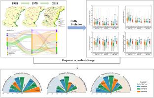
Gully erosion is one of the most severe types of land degradation, hindering food production and sustainable agricultural development. However, the historical evolution process and the impact of land use change on gully erosion remain unclear. To address this issue, we conducted a field investigation on gully erosion in 2018 and interpreted land use and gullies using historical remote sensing images in 1968 and 1978 over an area of 84.48 km2. The study found that from 1968 to 1978 to 2018, all gully morphological parameters including gully length density and gully areal density increased significantly. The main origin of gully erosion found was from dry farmland. The annual soil loss rate induced by gully erosion was 1.46 mm during 1968–2018. Gully erosion rates were higher during 1968–1978 than during 1978–2018. Furthermore, the length, areal and volumetric erosion rates in gullies formed by multiple gullies merging was greater than that of newly formed gullies (NFG) and gullies developing continuously from a single pre-existing gully, while the widening rate of NFG was highest. The susceptibility of land use types to gully erosion was in the order of woodland < dry farmland < degraded land. The annual average increase in gully area was 871.09 m2 km-2 year-1 for parcels that were converted from woodland to dry farmland, which was 5.56 times and 1.78 times greater than that of woodland and dry farmland maintenance, respectively. Therefore, urgent implementation of ecological land use plans and gully erosion control practices is suggested for this region.
期刊介绍:
The International Soil and Water Conservation Research (ISWCR), the official journal of World Association of Soil and Water Conservation (WASWAC) http://www.waswac.org, is a multidisciplinary journal of soil and water conservation research, practice, policy, and perspectives. It aims to disseminate new knowledge and promote the practice of soil and water conservation.
The scope of International Soil and Water Conservation Research includes research, strategies, and technologies for prediction, prevention, and protection of soil and water resources. It deals with identification, characterization, and modeling; dynamic monitoring and evaluation; assessment and management of conservation practice and creation and implementation of quality standards.
Examples of appropriate topical areas include (but are not limited to):
• Conservation models, tools, and technologies
• Conservation agricultural
• Soil health resources, indicators, assessment, and management
• Land degradation
• Sustainable development
• Soil erosion and its control
• Soil erosion processes
• Water resources assessment and management
• Watershed management
• Soil erosion models
• Literature review on topics related soil and water conservation research


 分享
分享
 求助内容:
求助内容: 应助结果提醒方式:
 扫码关注我们
