{"title":"2017年4月5日伊朗东北部6.0级地震:震源参数、余震序列和宏观地震表现","authors":"N. V. Petrova, L. V. Bezmenova, A. D. Kurova","doi":"10.3103/S0747923922070088","DOIUrl":null,"url":null,"abstract":"<p>The article considers the earthquake of April 5, 2017 with <i>M</i><sub><i>W</i></sub> <sub>GCMT</sub> = 6.0 near the Turkmen–Iranian border, northeast of the Iranian village of Sefid Sang. During the entire seismic history of the region, this was the strongest seismic event within a 45 km radius of the epicenter. The earthquake caused widespread destruction in four villages; two people died and 100 were injured. The shaking was felt in population centers in Iran, Turkmenistan, and other countries. According to the compiled isoseist map, the northwestern orientation of isolines of equal intensity, coinciding with the strike of the nearest faults, and strong damping of the shaking intensity across tectonic structures were established. The macroseismic field equation has been established, which is close to the Blake–Shebalin equation with average world coefficients. According to both equations, the shaking intensity at the epicenter is estimated as <i>I</i><sub>0</sub> = 8. The northwestern (southeastern) orientation of the aftershock cluster and their southeast migration were revealed, which made it possible to choose the nodal plane of the focal mechanism with a similar strike as the active one. The fault plane parameters, length <i>L</i> = 30 km and width <i>W</i> = 12 km, have been estimated for the area of the highest aftershock density. The law of the decrease in the number of aftershocks with time has been established, which indicates rapid decay of the aftershock process.</p>","PeriodicalId":45174,"journal":{"name":"Seismic Instruments","volume":"58 1","pages":"S1 - S13"},"PeriodicalIF":0.3000,"publicationDate":"2023-03-20","publicationTypes":"Journal Article","fieldsOfStudy":null,"isOpenAccess":false,"openAccessPdf":"","citationCount":"0","resultStr":"{\"title\":\"Earthquake of April 5, 2017, MW = 6.0, in Northeast Iran: Focal Parameters, Aftershock Series, and Macroseismic Manifestations\",\"authors\":\"N. V. Petrova, L. V. Bezmenova, A. D. Kurova\",\"doi\":\"10.3103/S0747923922070088\",\"DOIUrl\":null,\"url\":null,\"abstract\":\"<p>The article considers the earthquake of April 5, 2017 with <i>M</i><sub><i>W</i></sub> <sub>GCMT</sub> = 6.0 near the Turkmen–Iranian border, northeast of the Iranian village of Sefid Sang. During the entire seismic history of the region, this was the strongest seismic event within a 45 km radius of the epicenter. The earthquake caused widespread destruction in four villages; two people died and 100 were injured. The shaking was felt in population centers in Iran, Turkmenistan, and other countries. According to the compiled isoseist map, the northwestern orientation of isolines of equal intensity, coinciding with the strike of the nearest faults, and strong damping of the shaking intensity across tectonic structures were established. The macroseismic field equation has been established, which is close to the Blake–Shebalin equation with average world coefficients. According to both equations, the shaking intensity at the epicenter is estimated as <i>I</i><sub>0</sub> = 8. The northwestern (southeastern) orientation of the aftershock cluster and their southeast migration were revealed, which made it possible to choose the nodal plane of the focal mechanism with a similar strike as the active one. The fault plane parameters, length <i>L</i> = 30 km and width <i>W</i> = 12 km, have been estimated for the area of the highest aftershock density. The law of the decrease in the number of aftershocks with time has been established, which indicates rapid decay of the aftershock process.</p>\",\"PeriodicalId\":45174,\"journal\":{\"name\":\"Seismic Instruments\",\"volume\":\"58 1\",\"pages\":\"S1 - S13\"},\"PeriodicalIF\":0.3000,\"publicationDate\":\"2023-03-20\",\"publicationTypes\":\"Journal Article\",\"fieldsOfStudy\":null,\"isOpenAccess\":false,\"openAccessPdf\":\"\",\"citationCount\":\"0\",\"resultStr\":null,\"platform\":\"Semanticscholar\",\"paperid\":null,\"PeriodicalName\":\"Seismic Instruments\",\"FirstCategoryId\":\"1085\",\"ListUrlMain\":\"https://link.springer.com/article/10.3103/S0747923922070088\",\"RegionNum\":0,\"RegionCategory\":null,\"ArticlePicture\":[],\"TitleCN\":null,\"AbstractTextCN\":null,\"PMCID\":null,\"EPubDate\":\"\",\"PubModel\":\"\",\"JCR\":\"Q4\",\"JCRName\":\"GEOCHEMISTRY & GEOPHYSICS\",\"Score\":null,\"Total\":0}","platform":"Semanticscholar","paperid":null,"PeriodicalName":"Seismic Instruments","FirstCategoryId":"1085","ListUrlMain":"https://link.springer.com/article/10.3103/S0747923922070088","RegionNum":0,"RegionCategory":null,"ArticlePicture":[],"TitleCN":null,"AbstractTextCN":null,"PMCID":null,"EPubDate":"","PubModel":"","JCR":"Q4","JCRName":"GEOCHEMISTRY & GEOPHYSICS","Score":null,"Total":0}
Earthquake of April 5, 2017, MW = 6.0, in Northeast Iran: Focal Parameters, Aftershock Series, and Macroseismic Manifestations
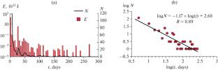
The article considers the earthquake of April 5, 2017 with MWGCMT = 6.0 near the Turkmen–Iranian border, northeast of the Iranian village of Sefid Sang. During the entire seismic history of the region, this was the strongest seismic event within a 45 km radius of the epicenter. The earthquake caused widespread destruction in four villages; two people died and 100 were injured. The shaking was felt in population centers in Iran, Turkmenistan, and other countries. According to the compiled isoseist map, the northwestern orientation of isolines of equal intensity, coinciding with the strike of the nearest faults, and strong damping of the shaking intensity across tectonic structures were established. The macroseismic field equation has been established, which is close to the Blake–Shebalin equation with average world coefficients. According to both equations, the shaking intensity at the epicenter is estimated as I0 = 8. The northwestern (southeastern) orientation of the aftershock cluster and their southeast migration were revealed, which made it possible to choose the nodal plane of the focal mechanism with a similar strike as the active one. The fault plane parameters, length L = 30 km and width W = 12 km, have been estimated for the area of the highest aftershock density. The law of the decrease in the number of aftershocks with time has been established, which indicates rapid decay of the aftershock process.
期刊介绍:
Seismic Instruments is a journal devoted to the description of geophysical instruments used in seismic research. In addition to covering the actual instruments for registering seismic waves, substantial room is devoted to solving instrumental-methodological problems of geophysical monitoring, applying various methods that are used to search for earthquake precursors, to studying earthquake nucleation processes and to monitoring natural and technogenous processes. The description of the construction, working elements, and technical characteristics of the instruments, as well as some results of implementation of the instruments and interpretation of the results are given. Attention is paid to seismic monitoring data and earthquake catalog quality Analysis.


 分享
分享
 求助内容:
求助内容: 应助结果提醒方式:
 扫码关注我们
