{"title":"鞑靼斯坦东南部超粘油田长期大地观测结果分析","authors":"R. N. Gatiyatulin, D. K. Kuzmin, E. A. Fattakhov","doi":"10.3103/S0747923922030057","DOIUrl":null,"url":null,"abstract":"<p>In 2012–2018, at the geodynamic survey area of the ultraviscous oil field of PJSC Tatneft, results of measurements of formations of the Earth’s surface were obtained using discrete geometric leveling and continuous satellite receivers (GNSS). Analysis of the results made it possible to compare the vertical displacement component obtained by two completely different measurement methods. The analytical model of the deformable formation made it possible to simulate subsidence of the Earth’s surface over the entire deposit, while showing consistency with the exceedance results obtained by the leveling method. The conducted spectral analysis according to GNSS data revealed a vast number of different spectra and also allowed us to calculate the trend velocity of the Earth’s surface.</p>","PeriodicalId":45174,"journal":{"name":"Seismic Instruments","volume":"58 3","pages":"270 - 282"},"PeriodicalIF":0.3000,"publicationDate":"2022-05-23","publicationTypes":"Journal Article","fieldsOfStudy":null,"isOpenAccess":false,"openAccessPdf":"","citationCount":"1","resultStr":"{\"title\":\"Analysis of the Results of Long-Term Geodetic Observations at the Ultra-Viscous Oil Field, South-East of Tatarstan\",\"authors\":\"R. N. Gatiyatulin, D. K. Kuzmin, E. A. Fattakhov\",\"doi\":\"10.3103/S0747923922030057\",\"DOIUrl\":null,\"url\":null,\"abstract\":\"<p>In 2012–2018, at the geodynamic survey area of the ultraviscous oil field of PJSC Tatneft, results of measurements of formations of the Earth’s surface were obtained using discrete geometric leveling and continuous satellite receivers (GNSS). Analysis of the results made it possible to compare the vertical displacement component obtained by two completely different measurement methods. The analytical model of the deformable formation made it possible to simulate subsidence of the Earth’s surface over the entire deposit, while showing consistency with the exceedance results obtained by the leveling method. The conducted spectral analysis according to GNSS data revealed a vast number of different spectra and also allowed us to calculate the trend velocity of the Earth’s surface.</p>\",\"PeriodicalId\":45174,\"journal\":{\"name\":\"Seismic Instruments\",\"volume\":\"58 3\",\"pages\":\"270 - 282\"},\"PeriodicalIF\":0.3000,\"publicationDate\":\"2022-05-23\",\"publicationTypes\":\"Journal Article\",\"fieldsOfStudy\":null,\"isOpenAccess\":false,\"openAccessPdf\":\"\",\"citationCount\":\"1\",\"resultStr\":null,\"platform\":\"Semanticscholar\",\"paperid\":null,\"PeriodicalName\":\"Seismic Instruments\",\"FirstCategoryId\":\"1085\",\"ListUrlMain\":\"https://link.springer.com/article/10.3103/S0747923922030057\",\"RegionNum\":0,\"RegionCategory\":null,\"ArticlePicture\":[],\"TitleCN\":null,\"AbstractTextCN\":null,\"PMCID\":null,\"EPubDate\":\"\",\"PubModel\":\"\",\"JCR\":\"Q4\",\"JCRName\":\"GEOCHEMISTRY & GEOPHYSICS\",\"Score\":null,\"Total\":0}","platform":"Semanticscholar","paperid":null,"PeriodicalName":"Seismic Instruments","FirstCategoryId":"1085","ListUrlMain":"https://link.springer.com/article/10.3103/S0747923922030057","RegionNum":0,"RegionCategory":null,"ArticlePicture":[],"TitleCN":null,"AbstractTextCN":null,"PMCID":null,"EPubDate":"","PubModel":"","JCR":"Q4","JCRName":"GEOCHEMISTRY & GEOPHYSICS","Score":null,"Total":0}
Analysis of the Results of Long-Term Geodetic Observations at the Ultra-Viscous Oil Field, South-East of Tatarstan
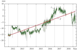
In 2012–2018, at the geodynamic survey area of the ultraviscous oil field of PJSC Tatneft, results of measurements of formations of the Earth’s surface were obtained using discrete geometric leveling and continuous satellite receivers (GNSS). Analysis of the results made it possible to compare the vertical displacement component obtained by two completely different measurement methods. The analytical model of the deformable formation made it possible to simulate subsidence of the Earth’s surface over the entire deposit, while showing consistency with the exceedance results obtained by the leveling method. The conducted spectral analysis according to GNSS data revealed a vast number of different spectra and also allowed us to calculate the trend velocity of the Earth’s surface.
期刊介绍:
Seismic Instruments is a journal devoted to the description of geophysical instruments used in seismic research. In addition to covering the actual instruments for registering seismic waves, substantial room is devoted to solving instrumental-methodological problems of geophysical monitoring, applying various methods that are used to search for earthquake precursors, to studying earthquake nucleation processes and to monitoring natural and technogenous processes. The description of the construction, working elements, and technical characteristics of the instruments, as well as some results of implementation of the instruments and interpretation of the results are given. Attention is paid to seismic monitoring data and earthquake catalog quality Analysis.


 分享
分享
 求助内容:
求助内容: 应助结果提醒方式:
 扫码关注我们
