{"title":"基于多传感器数据融合的园林布局规划建模研究","authors":"Pingfang Wen, Hongwu Xu","doi":"10.1049/wss2.12047","DOIUrl":null,"url":null,"abstract":"<p>In order to improve the rationality of landscape architecture layout planning and reduce the energy consumption in the process of data fusion, a landscape architecture layout planning modelling method based on multi-sensor data fusion is proposed in this study. Firstly, the spatial layer of landscape plants is divided, and the quantitative index value of landscape architecture is calculated by Simpson diversity index. Secondly, the weight of plant index is determined by analytic hierarchy process, and the error of garden image is analysed by unsupervised classification of garden image based on multi-sensor data fusion. Then, the garden image is classified according to the existing template, and the training samples of each category of garden are extracted. Finally, the modelling of landscape architecture layout planning is constructed, and the optimal planning method of landscape architecture layout based on maximum likelihood method is proposed. The experimental results show that this method can effectively reduce the energy consumption in the data fusion process, reduce the probability of damaged nodes becoming cluster heads, improve the stability of landscape forest layout planning method, match the plants according to the plant species, and improve the rationality of landscape architecture layout planning.</p>","PeriodicalId":51726,"journal":{"name":"IET Wireless Sensor Systems","volume":"13 1","pages":"24-36"},"PeriodicalIF":2.4000,"publicationDate":"2023-01-13","publicationTypes":"Journal Article","fieldsOfStudy":null,"isOpenAccess":false,"openAccessPdf":"https://onlinelibrary.wiley.com/doi/epdf/10.1049/wss2.12047","citationCount":"0","resultStr":"{\"title\":\"Research on modelling of landscape architecture layout planning based on multi-sensor data fusion\",\"authors\":\"Pingfang Wen, Hongwu Xu\",\"doi\":\"10.1049/wss2.12047\",\"DOIUrl\":null,\"url\":null,\"abstract\":\"<p>In order to improve the rationality of landscape architecture layout planning and reduce the energy consumption in the process of data fusion, a landscape architecture layout planning modelling method based on multi-sensor data fusion is proposed in this study. Firstly, the spatial layer of landscape plants is divided, and the quantitative index value of landscape architecture is calculated by Simpson diversity index. Secondly, the weight of plant index is determined by analytic hierarchy process, and the error of garden image is analysed by unsupervised classification of garden image based on multi-sensor data fusion. Then, the garden image is classified according to the existing template, and the training samples of each category of garden are extracted. Finally, the modelling of landscape architecture layout planning is constructed, and the optimal planning method of landscape architecture layout based on maximum likelihood method is proposed. The experimental results show that this method can effectively reduce the energy consumption in the data fusion process, reduce the probability of damaged nodes becoming cluster heads, improve the stability of landscape forest layout planning method, match the plants according to the plant species, and improve the rationality of landscape architecture layout planning.</p>\",\"PeriodicalId\":51726,\"journal\":{\"name\":\"IET Wireless Sensor Systems\",\"volume\":\"13 1\",\"pages\":\"24-36\"},\"PeriodicalIF\":2.4000,\"publicationDate\":\"2023-01-13\",\"publicationTypes\":\"Journal Article\",\"fieldsOfStudy\":null,\"isOpenAccess\":false,\"openAccessPdf\":\"https://onlinelibrary.wiley.com/doi/epdf/10.1049/wss2.12047\",\"citationCount\":\"0\",\"resultStr\":null,\"platform\":\"Semanticscholar\",\"paperid\":null,\"PeriodicalName\":\"IET Wireless Sensor Systems\",\"FirstCategoryId\":\"1085\",\"ListUrlMain\":\"https://onlinelibrary.wiley.com/doi/10.1049/wss2.12047\",\"RegionNum\":0,\"RegionCategory\":null,\"ArticlePicture\":[],\"TitleCN\":null,\"AbstractTextCN\":null,\"PMCID\":null,\"EPubDate\":\"\",\"PubModel\":\"\",\"JCR\":\"Q3\",\"JCRName\":\"TELECOMMUNICATIONS\",\"Score\":null,\"Total\":0}","platform":"Semanticscholar","paperid":null,"PeriodicalName":"IET Wireless Sensor Systems","FirstCategoryId":"1085","ListUrlMain":"https://onlinelibrary.wiley.com/doi/10.1049/wss2.12047","RegionNum":0,"RegionCategory":null,"ArticlePicture":[],"TitleCN":null,"AbstractTextCN":null,"PMCID":null,"EPubDate":"","PubModel":"","JCR":"Q3","JCRName":"TELECOMMUNICATIONS","Score":null,"Total":0}
Research on modelling of landscape architecture layout planning based on multi-sensor data fusion
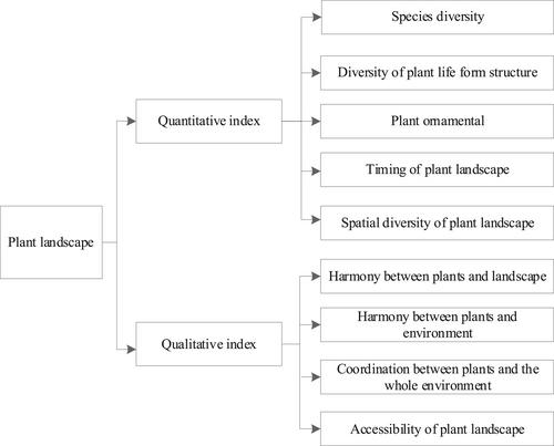
In order to improve the rationality of landscape architecture layout planning and reduce the energy consumption in the process of data fusion, a landscape architecture layout planning modelling method based on multi-sensor data fusion is proposed in this study. Firstly, the spatial layer of landscape plants is divided, and the quantitative index value of landscape architecture is calculated by Simpson diversity index. Secondly, the weight of plant index is determined by analytic hierarchy process, and the error of garden image is analysed by unsupervised classification of garden image based on multi-sensor data fusion. Then, the garden image is classified according to the existing template, and the training samples of each category of garden are extracted. Finally, the modelling of landscape architecture layout planning is constructed, and the optimal planning method of landscape architecture layout based on maximum likelihood method is proposed. The experimental results show that this method can effectively reduce the energy consumption in the data fusion process, reduce the probability of damaged nodes becoming cluster heads, improve the stability of landscape forest layout planning method, match the plants according to the plant species, and improve the rationality of landscape architecture layout planning.
期刊介绍:
IET Wireless Sensor Systems is aimed at the growing field of wireless sensor networks and distributed systems, which has been expanding rapidly in recent years and is evolving into a multi-billion dollar industry. The Journal has been launched to give a platform to researchers and academics in the field and is intended to cover the research, engineering, technological developments, innovative deployment of distributed sensor and actuator systems. Topics covered include, but are not limited to theoretical developments of: Innovative Architectures for Smart Sensors;Nano Sensors and Actuators Unstructured Networking; Cooperative and Clustering Distributed Sensors; Data Fusion for Distributed Sensors; Distributed Intelligence in Distributed Sensors; Energy Harvesting for and Lifetime of Smart Sensors and Actuators; Cross-Layer Design and Layer Optimisation in Distributed Sensors; Security, Trust and Dependability of Distributed Sensors. The Journal also covers; Innovative Services and Applications for: Monitoring: Health, Traffic, Weather and Toxins; Surveillance: Target Tracking and Localization; Observation: Global Resources and Geological Activities (Earth, Forest, Mines, Underwater); Industrial Applications of Distributed Sensors in Green and Agile Manufacturing; Sensor and RFID Applications of the Internet-of-Things ("IoT"); Smart Metering; Machine-to-Machine Communications.


 分享
分享
 求助内容:
求助内容: 应助结果提醒方式:
 扫码关注我们
