Identification of groundwater potential zones using geospatial techniques and analytical hierarchy process (AHP): case of the middle and high Cheliff basin, Algeria
{"title":"Identification of groundwater potential zones using geospatial techniques and analytical hierarchy process (AHP): case of the middle and high Cheliff basin, Algeria","authors":"Djamel Maizi, Abdelmadjid Boufekane, Gianluigi Busico","doi":"10.1007/s12518-023-00536-5","DOIUrl":null,"url":null,"abstract":"<div><p>This study aims to delineate groundwater potential zones using an integrated approach of remote sensing (RS), geographical information system (GIS), and analytical hierarchy process (AHP) method in the middle and high Cheliff basin, Algeria. Multiple data such as lithology, lineament density, geomorphology, slope, soil, rainfall, drainage density, and land use/land cover were considered for delineating the groundwater potential zones. Spatially distributed maps/thematic layers of all the aforementioned parameters were created using remotely sensed data as well as ground data in a GIS environment. The assigned weights of the thematic layers and their features were then normalized by using the AHP technique. The delineated groundwater potential zones in this study area were categorized as very good, good, moderate, and poor, respectively. The results showed that the area along the Chlef River which is approximately 6% of the total study area was delineated as an area having “very good” potential for groundwater. The “good zone” delineated encompassed approximately 31% of the study area and was found in the pediment-pediplain complex zone. The moderate zones encompassed approximately 58% of the area. The “poor zones” encompassed approximately 5% of the area which included the cities of Ramka, El Hadjadj, Moussadek, and certain parts of Mekhatria. The groundwater potential zones map was compared with the actual discharge data from various wells within the study area and was found reasonable. Overall, this study provides a convenient approach of delineating the potential of groundwater availability which ultimately will aid in better planning and managing of groundwater resources.</p><h3>Graphical abstract</h3>\n<div><figure><div><div><picture><source><img></source></picture></div></div></figure></div></div>","PeriodicalId":46286,"journal":{"name":"Applied Geomatics","volume":"15 4","pages":"1005 - 1017"},"PeriodicalIF":2.3000,"publicationDate":"2023-11-13","publicationTypes":"Journal Article","fieldsOfStudy":null,"isOpenAccess":false,"openAccessPdf":"","citationCount":"0","resultStr":null,"platform":"Semanticscholar","paperid":null,"PeriodicalName":"Applied Geomatics","FirstCategoryId":"1085","ListUrlMain":"https://link.springer.com/article/10.1007/s12518-023-00536-5","RegionNum":0,"RegionCategory":null,"ArticlePicture":[],"TitleCN":null,"AbstractTextCN":null,"PMCID":null,"EPubDate":"","PubModel":"","JCR":"Q2","JCRName":"REMOTE SENSING","Score":null,"Total":0}
引用次数: 0
Abstract
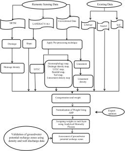
This study aims to delineate groundwater potential zones using an integrated approach of remote sensing (RS), geographical information system (GIS), and analytical hierarchy process (AHP) method in the middle and high Cheliff basin, Algeria. Multiple data such as lithology, lineament density, geomorphology, slope, soil, rainfall, drainage density, and land use/land cover were considered for delineating the groundwater potential zones. Spatially distributed maps/thematic layers of all the aforementioned parameters were created using remotely sensed data as well as ground data in a GIS environment. The assigned weights of the thematic layers and their features were then normalized by using the AHP technique. The delineated groundwater potential zones in this study area were categorized as very good, good, moderate, and poor, respectively. The results showed that the area along the Chlef River which is approximately 6% of the total study area was delineated as an area having “very good” potential for groundwater. The “good zone” delineated encompassed approximately 31% of the study area and was found in the pediment-pediplain complex zone. The moderate zones encompassed approximately 58% of the area. The “poor zones” encompassed approximately 5% of the area which included the cities of Ramka, El Hadjadj, Moussadek, and certain parts of Mekhatria. The groundwater potential zones map was compared with the actual discharge data from various wells within the study area and was found reasonable. Overall, this study provides a convenient approach of delineating the potential of groundwater availability which ultimately will aid in better planning and managing of groundwater resources.
期刊介绍:
Applied Geomatics (AGMJ) is the official journal of SIFET the Italian Society of Photogrammetry and Topography and covers all aspects and information on scientific and technical advances in the geomatics sciences. The Journal publishes innovative contributions in geomatics applications ranging from the integration of instruments, methodologies and technologies and their use in the environmental sciences, engineering and other natural sciences.
The areas of interest include many research fields such as: remote sensing, close range and videometric photogrammetry, image analysis, digital mapping, land and geographic information systems, geographic information science, integrated geodesy, spatial data analysis, heritage recording; network adjustment and numerical processes. Furthermore, Applied Geomatics is open to articles from all areas of deformation measurements and analysis, structural engineering, mechanical engineering and all trends in earth and planetary survey science and space technology. The Journal also contains notices of conferences and international workshops, industry news, and information on new products. It provides a useful forum for professional and academic scientists involved in geomatics science and technology.
Information on Open Research Funding and Support may be found here: https://www.springernature.com/gp/open-research/institutional-agreements


 分享
分享
 求助内容:
求助内容: 应助结果提醒方式:
 扫码关注我们
