Catharina Cavasin Salvador, Adalberto Aparecido Dos Santos Lopes, Danilo Resendes, Fernanda Faccio Demarco, Marcelo Dutra Della Justina, Renato Tibiriçá de Saboya, Cassiano Ricardo Rech, Eleonora d'Orsi
{"title":"Geocoding processes in cohort studies: methods applied in the EpiFloripa Aging.","authors":"Catharina Cavasin Salvador, Adalberto Aparecido Dos Santos Lopes, Danilo Resendes, Fernanda Faccio Demarco, Marcelo Dutra Della Justina, Renato Tibiriçá de Saboya, Cassiano Ricardo Rech, Eleonora d'Orsi","doi":"10.11606/s1518-8787.2023057004976","DOIUrl":null,"url":null,"abstract":"<p><strong>Objective: </strong>To describe the process and epidemiological implications of georeferencing in EpiFloripa Aging samples (2009-2019).</p><p><strong>Method: </strong>The EpiFloripa Aging Cohort Study sought to investigate and monitor the living and health conditions of the older adult population (≥ 60) of Florianópolis in three study waves (2009/2010, 2013/2014, 2017/2019). With an automatic geocoding tool, the residential addresses were spatialized, allowing to investigate the effect of the georeferencing sample losses regarding 19 variables, evaluated in the three waves. The influence of different neighborhood definitions (census tracts, Euclidean buffers, and buffers across the street network) was examined in the results of seven variables: area, income, residential density, mixed land use, connectivity, health unit count, and public open space count. Pearson's correlation coefficients were calculated to evaluate the differences between neighborhood definitions according to three variables: contextual income, residential density, and land use diversity.</p><p><strong>Result: </strong>The losses imposed by geocoding (6%, n = 240) caused no statistically significant difference between the total sample and the geocoded sample. The analysis of the study variables suggests that the geocoding process may have included a higher proportion of participants with better income, education, and living conditions. The correlation coefficients showed little correspondence between measures calculated by the three neighborhood definitions (r = 0.37-0.54). The statistical difference between the variables calculated by buffers and census tracts highlights limitations in their use in the description of geospatial attributes.</p><p><strong>Conclusion: </strong>Despite the challenges related to geocoding, such as inconsistencies in addresses, adequate correction and verification mechanisms provided a high rate of assignment of geographic coordinates, the findings suggest that adopting buffers, favored by geocoding, represents a potential for spatial epidemiological analyses by improving the representation of environmental attributes and the understanding of health outcomes.</p>","PeriodicalId":21230,"journal":{"name":"Revista de saude publica","volume":"57 ","pages":"88"},"PeriodicalIF":2.1000,"publicationDate":"2023-11-13","publicationTypes":"Journal Article","fieldsOfStudy":null,"isOpenAccess":false,"openAccessPdf":"https://www.ncbi.nlm.nih.gov/pmc/articles/PMC10681526/pdf/","citationCount":"0","resultStr":null,"platform":"Semanticscholar","paperid":null,"PeriodicalName":"Revista de saude publica","FirstCategoryId":"3","ListUrlMain":"https://doi.org/10.11606/s1518-8787.2023057004976","RegionNum":4,"RegionCategory":"医学","ArticlePicture":[],"TitleCN":null,"AbstractTextCN":null,"PMCID":null,"EPubDate":"2023/1/1 0:00:00","PubModel":"eCollection","JCR":"Q3","JCRName":"PUBLIC, ENVIRONMENTAL & OCCUPATIONAL HEALTH","Score":null,"Total":0}
引用次数: 0
Abstract
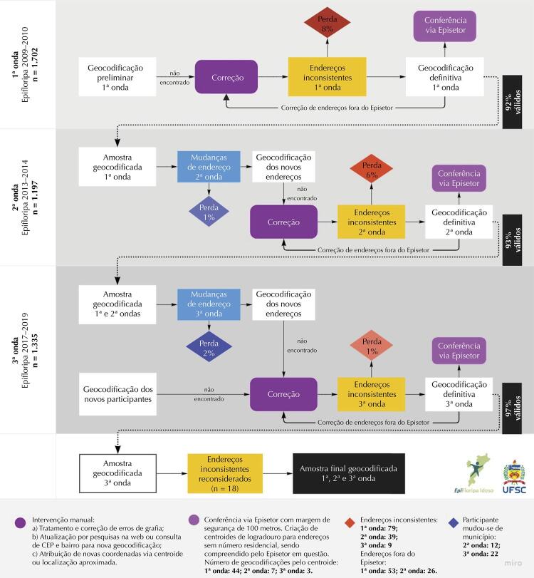
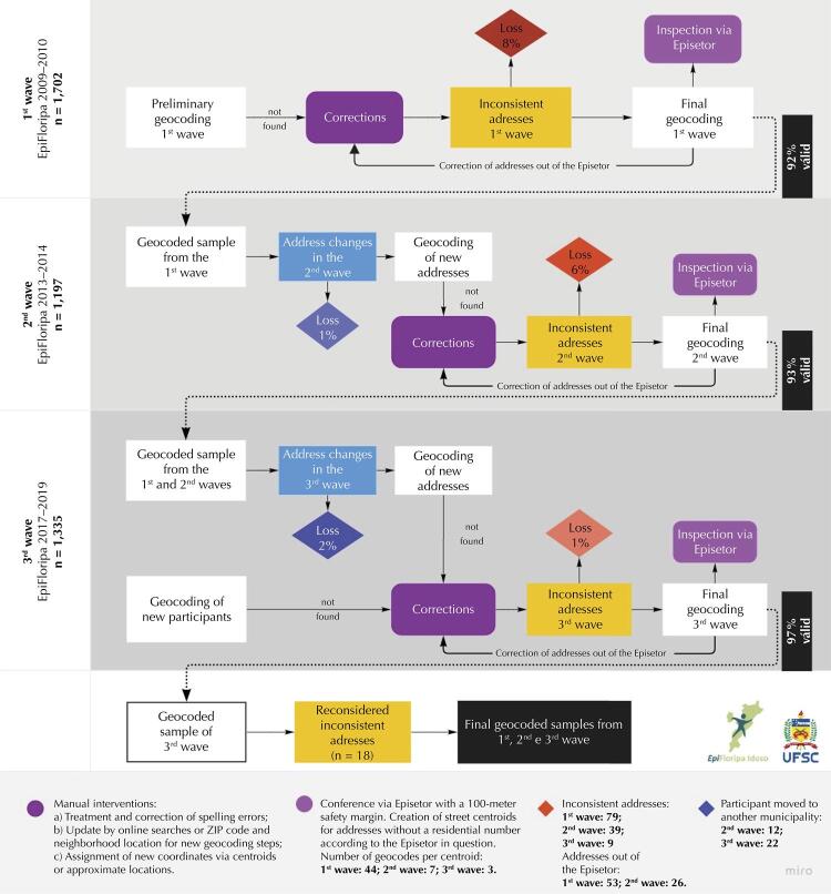
Objective: To describe the process and epidemiological implications of georeferencing in EpiFloripa Aging samples (2009-2019).
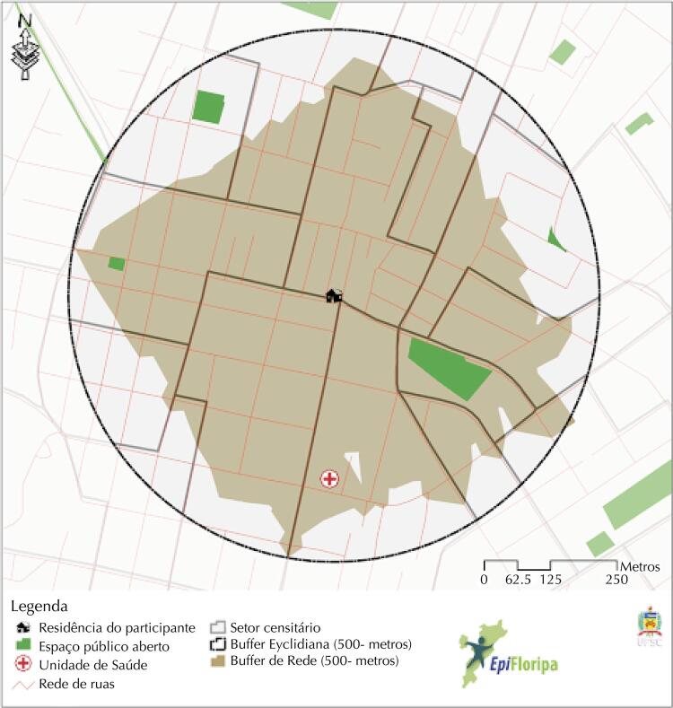
Method: The EpiFloripa Aging Cohort Study sought to investigate and monitor the living and health conditions of the older adult population (≥ 60) of Florianópolis in three study waves (2009/2010, 2013/2014, 2017/2019). With an automatic geocoding tool, the residential addresses were spatialized, allowing to investigate the effect of the georeferencing sample losses regarding 19 variables, evaluated in the three waves. The influence of different neighborhood definitions (census tracts, Euclidean buffers, and buffers across the street network) was examined in the results of seven variables: area, income, residential density, mixed land use, connectivity, health unit count, and public open space count. Pearson's correlation coefficients were calculated to evaluate the differences between neighborhood definitions according to three variables: contextual income, residential density, and land use diversity.
Result: The losses imposed by geocoding (6%, n = 240) caused no statistically significant difference between the total sample and the geocoded sample. The analysis of the study variables suggests that the geocoding process may have included a higher proportion of participants with better income, education, and living conditions. The correlation coefficients showed little correspondence between measures calculated by the three neighborhood definitions (r = 0.37-0.54). The statistical difference between the variables calculated by buffers and census tracts highlights limitations in their use in the description of geospatial attributes.
Conclusion: Despite the challenges related to geocoding, such as inconsistencies in addresses, adequate correction and verification mechanisms provided a high rate of assignment of geographic coordinates, the findings suggest that adopting buffers, favored by geocoding, represents a potential for spatial epidemiological analyses by improving the representation of environmental attributes and the understanding of health outcomes.


 分享
分享
 求助内容:
求助内容: 应助结果提醒方式:
 扫码关注我们
