{"title":"The effect of data sources on calculating mean temperature and integrated water vapor in Iran","authors":"Hassan Rahimi, Jamal Asgari, Vahab Nafisi","doi":"10.1002/met.2167","DOIUrl":null,"url":null,"abstract":"<p>The weighted mean temperature (<math>\n <mrow>\n <msub>\n <mi>T</mi>\n <mi>m</mi>\n </msub>\n </mrow></math>) plays a crucial role in calculating Precipitable Water Vapor (PWV) and integrated water vapor (IWV) using Global Navigation Satellite Systems (GNSS) techniques. Currently, the primary sources for meteorological parameters are radiosonde measurements and Numerical Weather Models (NWMs). This study focuses on assessing the influence of different data sources on the computation of <math>\n <mrow>\n <msub>\n <mi>T</mi>\n <mi>m</mi>\n </msub>\n </mrow></math> and IWV in Iran. The investigation involved comparing several datasets: ERA5 numerical data with spatial resolutions of 0.125° and 2.5° (ERA5 0.125, ERA5 2.5), ERA-Interim, NCEP numerical data and <math>\n <mrow>\n <msub>\n <mi>T</mi>\n <mi>m</mi>\n </msub>\n </mrow></math> results derived from the GPT3 model. Validation of the results utilized data from 12 radiosonde stations situated across Iran. In addition, the precision of the IWV parameter was evaluated by utilizing measurements from the only available IGS station in the region, situated in Tehran. The results revealed that ERA5 0.125 exhibited superior accuracy in <math>\n <mrow>\n <msub>\n <mi>T</mi>\n <mi>m</mi>\n </msub>\n </mrow></math> estimation compared with the other datasets, showing a discrepancy of approximately 1–2 K. In contrast, the GPT3 model displayed an accuracy of about 3 K. Analysing the results across different months of the year revealed elevated root mean square error (RMSE) values during warmer months, with little variability based on station height in the region for the four datasets. Regarding IWV, the ERA5 0.125 dataset outperformed the other three datasets, demonstrating an accuracy of about 0.07 kg m<sup>−2</sup>. Notably, RMSE values during summer were approximately 50% higher compared with the annual RMSE.</p>","PeriodicalId":49825,"journal":{"name":"Meteorological Applications","volume":"30 6","pages":""},"PeriodicalIF":2.5000,"publicationDate":"2023-12-13","publicationTypes":"Journal Article","fieldsOfStudy":null,"isOpenAccess":false,"openAccessPdf":"https://rmets.onlinelibrary.wiley.com/doi/epdf/10.1002/met.2167","citationCount":"0","resultStr":null,"platform":"Semanticscholar","paperid":null,"PeriodicalName":"Meteorological Applications","FirstCategoryId":"89","ListUrlMain":"https://onlinelibrary.wiley.com/doi/10.1002/met.2167","RegionNum":4,"RegionCategory":"地球科学","ArticlePicture":[],"TitleCN":null,"AbstractTextCN":null,"PMCID":null,"EPubDate":"","PubModel":"","JCR":"Q3","JCRName":"METEOROLOGY & ATMOSPHERIC SCIENCES","Score":null,"Total":0}
引用次数: 0
Abstract
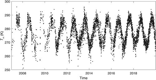
The weighted mean temperature () plays a crucial role in calculating Precipitable Water Vapor (PWV) and integrated water vapor (IWV) using Global Navigation Satellite Systems (GNSS) techniques. Currently, the primary sources for meteorological parameters are radiosonde measurements and Numerical Weather Models (NWMs). This study focuses on assessing the influence of different data sources on the computation of and IWV in Iran. The investigation involved comparing several datasets: ERA5 numerical data with spatial resolutions of 0.125° and 2.5° (ERA5 0.125, ERA5 2.5), ERA-Interim, NCEP numerical data and results derived from the GPT3 model. Validation of the results utilized data from 12 radiosonde stations situated across Iran. In addition, the precision of the IWV parameter was evaluated by utilizing measurements from the only available IGS station in the region, situated in Tehran. The results revealed that ERA5 0.125 exhibited superior accuracy in estimation compared with the other datasets, showing a discrepancy of approximately 1–2 K. In contrast, the GPT3 model displayed an accuracy of about 3 K. Analysing the results across different months of the year revealed elevated root mean square error (RMSE) values during warmer months, with little variability based on station height in the region for the four datasets. Regarding IWV, the ERA5 0.125 dataset outperformed the other three datasets, demonstrating an accuracy of about 0.07 kg m−2. Notably, RMSE values during summer were approximately 50% higher compared with the annual RMSE.
期刊介绍:
The aim of Meteorological Applications is to serve the needs of applied meteorologists, forecasters and users of meteorological services by publishing papers on all aspects of meteorological science, including:
applications of meteorological, climatological, analytical and forecasting data, and their socio-economic benefits;
forecasting, warning and service delivery techniques and methods;
weather hazards, their analysis and prediction;
performance, verification and value of numerical models and forecasting services;
practical applications of ocean and climate models;
education and training.


 分享
分享
 求助内容:
求助内容: 应助结果提醒方式:
 扫码关注我们
