Giannis Apostolou, Konstantina Venieri, Alfredo Mayoral, Sofia Dimaki, Arnau Garcia-Molsosa, Mercourios Georgiadis, Hector A. Orengo
{"title":"Integrating legacy survey data into GIS-based analysis: The rediscovery of the archaeological landscapes in Grevena (Western Macedonia, Greece)","authors":"Giannis Apostolou, Konstantina Venieri, Alfredo Mayoral, Sofia Dimaki, Arnau Garcia-Molsosa, Mercourios Georgiadis, Hector A. Orengo","doi":"10.1002/arp.1926","DOIUrl":null,"url":null,"abstract":"<p>Surface archaeological survey has been widely established as the principal method for the regional study of Mediterranean diachronic landscapes. Before the introduction of GPS and digital, GIS-based recordings in the late 1990s, survey projects employed analogue recording strategies (e.g. personal notebooks, printed forms and cartographic materials) resulting in low-precision spatial datasets. These archives, termed here as legacy survey data, can today be visualized and analysed using computational tools. The aim of the present work is to exemplify how legacy data can be reused and reproduced to explore unknown aspects of past survey projects. It showcases a multi-source, GIS-structured workflow to manage and re-evaluate data from the region of Grevena, north-western Greece, where a largely unpublished all-period extensive survey titled the Grevena Project has pinpointed a rich, yet unavailable to the archaeological community cultural record. The publications lacked critical evaluation of the survey results and significance, such as accurate site locations, size and chronology as well as a description of the field collection strategies used. To recover and combine these data into a single geodataset, a three-step workflow was created, including the systematic recording of collected artefacts, the deployment of archival and remote-sensing resources (e.g. georeferenced cartographic and photographic materials and satellite imagery) and the development of a new extensive survey in selected areas for validation purposes. Results indicated heterogeneity in the techniques employed by the Grevena Project for site recognition. They also brought an important assemblage of Palaeolithic finds unrecorded before. Furthermore, large-scale geomorphological analysis using geomorphometric approaches demonstrated an irregularly high density of sites in elevated areas, which is considered a surveying bias. Remote sensing sources including archival aerial photographs highlighted regional landscape changes (e.g. in forest coverage) revealing architectural remains unmapped before. Finally, the new survey around Ayios Georgios showed the discovery of several new sites, emphasizing a case study of much more complex dynamics than originally considered during the Grevena Project.</p>","PeriodicalId":55490,"journal":{"name":"Archaeological Prospection","volume":"31 1","pages":"37-52"},"PeriodicalIF":1.9000,"publicationDate":"2024-01-28","publicationTypes":"Journal Article","fieldsOfStudy":null,"isOpenAccess":false,"openAccessPdf":"https://onlinelibrary.wiley.com/doi/epdf/10.1002/arp.1926","citationCount":"0","resultStr":null,"platform":"Semanticscholar","paperid":null,"PeriodicalName":"Archaeological Prospection","FirstCategoryId":"89","ListUrlMain":"https://onlinelibrary.wiley.com/doi/10.1002/arp.1926","RegionNum":3,"RegionCategory":"地球科学","ArticlePicture":[],"TitleCN":null,"AbstractTextCN":null,"PMCID":null,"EPubDate":"","PubModel":"","JCR":"0","JCRName":"ARCHAEOLOGY","Score":null,"Total":0}
引用次数: 0
Abstract
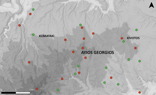
Surface archaeological survey has been widely established as the principal method for the regional study of Mediterranean diachronic landscapes. Before the introduction of GPS and digital, GIS-based recordings in the late 1990s, survey projects employed analogue recording strategies (e.g. personal notebooks, printed forms and cartographic materials) resulting in low-precision spatial datasets. These archives, termed here as legacy survey data, can today be visualized and analysed using computational tools. The aim of the present work is to exemplify how legacy data can be reused and reproduced to explore unknown aspects of past survey projects. It showcases a multi-source, GIS-structured workflow to manage and re-evaluate data from the region of Grevena, north-western Greece, where a largely unpublished all-period extensive survey titled the Grevena Project has pinpointed a rich, yet unavailable to the archaeological community cultural record. The publications lacked critical evaluation of the survey results and significance, such as accurate site locations, size and chronology as well as a description of the field collection strategies used. To recover and combine these data into a single geodataset, a three-step workflow was created, including the systematic recording of collected artefacts, the deployment of archival and remote-sensing resources (e.g. georeferenced cartographic and photographic materials and satellite imagery) and the development of a new extensive survey in selected areas for validation purposes. Results indicated heterogeneity in the techniques employed by the Grevena Project for site recognition. They also brought an important assemblage of Palaeolithic finds unrecorded before. Furthermore, large-scale geomorphological analysis using geomorphometric approaches demonstrated an irregularly high density of sites in elevated areas, which is considered a surveying bias. Remote sensing sources including archival aerial photographs highlighted regional landscape changes (e.g. in forest coverage) revealing architectural remains unmapped before. Finally, the new survey around Ayios Georgios showed the discovery of several new sites, emphasizing a case study of much more complex dynamics than originally considered during the Grevena Project.
期刊介绍:
The scope of the Journal will be international, covering urban, rural and marine environments and the full range of underlying geology.
The Journal will contain articles relating to the use of a wide range of propecting techniques, including remote sensing (airborne and satellite), geophysical (e.g. resistivity, magnetometry) and geochemical (e.g. organic markers, soil phosphate). Reports and field evaluations of new techniques will be welcomed.
Contributions will be encouraged on the application of relevant software, including G.I.S. analysis, to the data derived from prospection techniques and cartographic analysis of early maps.
Reports on integrated site evaluations and follow-up site investigations will be particularly encouraged.
The Journal will welcome contributions, in the form of short (field) reports, on the application of prospection techniques in support of comprehensive land-use studies.
The Journal will, as appropriate, contain book reviews, conference and meeting reviews, and software evaluation.
All papers will be subjected to peer review.


 分享
分享
 求助内容:
求助内容: 应助结果提醒方式:
 扫码关注我们
