N. R. Ermolaev, S. A. Yudin, V. P. Belobrov, L. A. Vedeshin, D. A. Shapovalov
{"title":"Using Deep Learning and Cloud Services for Mapping Agricultural Fields on the Basis of Remote Sensing Data of the Earth","authors":"N. R. Ermolaev, S. A. Yudin, V. P. Belobrov, L. A. Vedeshin, D. A. Shapovalov","doi":"10.1134/s0001433823120083","DOIUrl":null,"url":null,"abstract":"<h3 data-test=\"abstract-sub-heading\">Abstract</h3><p>In recent years, research has been conducted in scientific institutions of the Ministry of Agriculture of the Russian Federation and the Russian Academy of Sciences on introducing new technologies for the use of aerospace information in agriculture. This article, using the example of Stavropol krai, considers the possibility of using cloud services such as Google Earth Engine (GEE) and Kaggle machine learning systems for mapping agricultural fields using deep learning methods based on remote sensing data. Median images of the Sentinel 2 space system for the 2022 growing season are used as data for the selection of training and validation samples. The total volume of the prepared training samples is 3998 images. One problem for researchers and manufacturers in the field of agriculture is a lack of centralized and verified sources of geospatial data. Deep learning methods are able to solve this problem by automating the task of digitizing the geometries of agricultural fields based on remote sensing data. One of the limitations in the widespread use of deep learning is its high demand for computing resources, which are not always available to a researcher or manufacturer in the field of agriculture. This paper describes the process of preparing the necessary data for working with a neural network, including correcting and obtaining satellite images using GEE, their standardization for training a neural network in Kaggle, and further use locally. A neural network of the U-net architecture is used as part of the study. The final classification quality is 97%. The threshold of division into classes according to the classification results is established empirically and amounts to 0.62. The proposed approach makes it possible to significantly reduce the requirements for the local use of PC computing power. All the most resource-intensive processes related to the processing of satellite images are performed in the GEE system, and the learning process is transferred to the resources of the Kaggle system. The proposed combination of cloud services and deep learning methods can contribute to a wider spread of the use of modern technologies in agricultural production and scientific research.</p>","PeriodicalId":54911,"journal":{"name":"Izvestiya Atmospheric and Oceanic Physics","volume":"15 1","pages":""},"PeriodicalIF":0.6000,"publicationDate":"2024-02-20","publicationTypes":"Journal Article","fieldsOfStudy":null,"isOpenAccess":false,"openAccessPdf":"","citationCount":"0","resultStr":null,"platform":"Semanticscholar","paperid":null,"PeriodicalName":"Izvestiya Atmospheric and Oceanic Physics","FirstCategoryId":"89","ListUrlMain":"https://doi.org/10.1134/s0001433823120083","RegionNum":4,"RegionCategory":"地球科学","ArticlePicture":[],"TitleCN":null,"AbstractTextCN":null,"PMCID":null,"EPubDate":"","PubModel":"","JCR":"Q4","JCRName":"METEOROLOGY & ATMOSPHERIC SCIENCES","Score":null,"Total":0}
引用次数: 0
Abstract
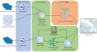
In recent years, research has been conducted in scientific institutions of the Ministry of Agriculture of the Russian Federation and the Russian Academy of Sciences on introducing new technologies for the use of aerospace information in agriculture. This article, using the example of Stavropol krai, considers the possibility of using cloud services such as Google Earth Engine (GEE) and Kaggle machine learning systems for mapping agricultural fields using deep learning methods based on remote sensing data. Median images of the Sentinel 2 space system for the 2022 growing season are used as data for the selection of training and validation samples. The total volume of the prepared training samples is 3998 images. One problem for researchers and manufacturers in the field of agriculture is a lack of centralized and verified sources of geospatial data. Deep learning methods are able to solve this problem by automating the task of digitizing the geometries of agricultural fields based on remote sensing data. One of the limitations in the widespread use of deep learning is its high demand for computing resources, which are not always available to a researcher or manufacturer in the field of agriculture. This paper describes the process of preparing the necessary data for working with a neural network, including correcting and obtaining satellite images using GEE, their standardization for training a neural network in Kaggle, and further use locally. A neural network of the U-net architecture is used as part of the study. The final classification quality is 97%. The threshold of division into classes according to the classification results is established empirically and amounts to 0.62. The proposed approach makes it possible to significantly reduce the requirements for the local use of PC computing power. All the most resource-intensive processes related to the processing of satellite images are performed in the GEE system, and the learning process is transferred to the resources of the Kaggle system. The proposed combination of cloud services and deep learning methods can contribute to a wider spread of the use of modern technologies in agricultural production and scientific research.
期刊介绍:
Izvestiya, Atmospheric and Oceanic Physics is a journal that publishes original scientific research and review articles on vital issues in the physics of the Earth’s atmosphere and hydrosphere and climate theory. The journal presents results of recent studies of physical processes in the atmosphere and ocean that control climate, weather, and their changes. These studies have possible practical applications. The journal also gives room to the discussion of results obtained in theoretical and experimental studies in various fields of oceanic and atmospheric physics, such as the dynamics of gas and water media, interaction of the atmosphere with the ocean and land surfaces, turbulence theory, heat balance and radiation processes, remote sensing and optics of both media, natural and man-induced climate changes, and the state of the atmosphere and ocean. The journal publishes papers on research techniques used in both media, current scientific information on domestic and foreign events in the physics of the atmosphere and ocean.


 分享
分享
 求助内容:
求助内容: 应助结果提醒方式:
 扫码关注我们
