Digital elevation model cell size effect on erosion-deposition simulation using the unit stream power erosion and deposition model in the dry-hot valley region of Southwest China
Dan Yang, Jiayan Jiang, Mingliang Luo, Jin Huang, Yali Xu, Yushou Yu, Qiang Xiao
{"title":"Digital elevation model cell size effect on erosion-deposition simulation using the unit stream power erosion and deposition model in the dry-hot valley region of Southwest China","authors":"Dan Yang, Jiayan Jiang, Mingliang Luo, Jin Huang, Yali Xu, Yushou Yu, Qiang Xiao","doi":"10.1002/esp.5799","DOIUrl":null,"url":null,"abstract":"<p>Gully erosion is the main source of sediment in watersheds, and the assessment of soil erosion and deposition in gully systems is very important for land utilization and watershed management. Soil erosion and sediment transport are multiscale, and the digital elevation model (DEM) is one of the most important means to study the scale effect of soil erosion and deposition. To clarify the effect of DEM cell size on soil erosion and deposition in gullies, a series of DEMs with cell sizes of 0.5, 0.7, 1, 1.5, 2, 2.5, 3, 4 and 5 m were generated based on detailed field measurements in dry-hot valley region. Meanwhile, the unit stream power erosion and deposition (USPED) model was chosen to simulate soil erosion and deposition in this study. The results showed that cell size can greatly influence the average slope and aspect of the DEMs, while the accuracy and average elevation of the DEMs were only affected intensively when the cell size exceeds 3 m. As for the spatial distribution pattern of soil erosion and deposition, the increase of the DEM cell size could cause a concentration of soil erosion and deposition in main channels while weakening the occurrence on hillslopes, and the spatial proximity of soil erosion and deposition would not change with the DEM cell size. The highly positive correlation in simulation results for soil erosion and deposition was primarily observed in DEM cell sizes range of 0.5 to 2 m and from 3 to 5 m. Meanwhile, a slight increase in DEM cell size would significantly affect the simulated results of soil erosion and deposition based on the USPED model when DEM cell size ranged from 0.5 to 0.7 m, whereas the change in DEM cell size would not affect the simulation results when DEM cell size was greater than 0.7 m.</p>","PeriodicalId":11408,"journal":{"name":"Earth Surface Processes and Landforms","volume":null,"pages":null},"PeriodicalIF":2.8000,"publicationDate":"2024-02-29","publicationTypes":"Journal Article","fieldsOfStudy":null,"isOpenAccess":false,"openAccessPdf":"","citationCount":"0","resultStr":null,"platform":"Semanticscholar","paperid":null,"PeriodicalName":"Earth Surface Processes and Landforms","FirstCategoryId":"89","ListUrlMain":"https://onlinelibrary.wiley.com/doi/10.1002/esp.5799","RegionNum":3,"RegionCategory":"地球科学","ArticlePicture":[],"TitleCN":null,"AbstractTextCN":null,"PMCID":null,"EPubDate":"","PubModel":"","JCR":"Q2","JCRName":"GEOGRAPHY, PHYSICAL","Score":null,"Total":0}
引用次数: 0
Abstract
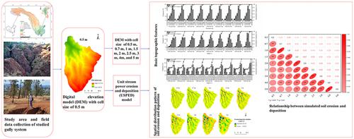
Gully erosion is the main source of sediment in watersheds, and the assessment of soil erosion and deposition in gully systems is very important for land utilization and watershed management. Soil erosion and sediment transport are multiscale, and the digital elevation model (DEM) is one of the most important means to study the scale effect of soil erosion and deposition. To clarify the effect of DEM cell size on soil erosion and deposition in gullies, a series of DEMs with cell sizes of 0.5, 0.7, 1, 1.5, 2, 2.5, 3, 4 and 5 m were generated based on detailed field measurements in dry-hot valley region. Meanwhile, the unit stream power erosion and deposition (USPED) model was chosen to simulate soil erosion and deposition in this study. The results showed that cell size can greatly influence the average slope and aspect of the DEMs, while the accuracy and average elevation of the DEMs were only affected intensively when the cell size exceeds 3 m. As for the spatial distribution pattern of soil erosion and deposition, the increase of the DEM cell size could cause a concentration of soil erosion and deposition in main channels while weakening the occurrence on hillslopes, and the spatial proximity of soil erosion and deposition would not change with the DEM cell size. The highly positive correlation in simulation results for soil erosion and deposition was primarily observed in DEM cell sizes range of 0.5 to 2 m and from 3 to 5 m. Meanwhile, a slight increase in DEM cell size would significantly affect the simulated results of soil erosion and deposition based on the USPED model when DEM cell size ranged from 0.5 to 0.7 m, whereas the change in DEM cell size would not affect the simulation results when DEM cell size was greater than 0.7 m.
沟壑侵蚀是流域泥沙的主要来源,评估沟壑系统中的土壤侵蚀和沉积对土地利用和流域管理非常重要。土壤侵蚀和泥沙输移是多尺度的,而数字高程模型(DEM)是研究土壤侵蚀和沉积尺度效应的重要手段之一。为了明确 DEM 单元大小对沟谷土壤侵蚀和沉积的影响,根据干热河谷地区的详细实地测量结果,生成了一系列单元大小为 0.5、0.7、1、1.5、2、2.5、3、4 和 5 m 的 DEM。同时,本研究选择了单位流动力侵蚀和沉积(USPED)模型来模拟土壤侵蚀和沉积。结果表明,单元大小会对 DEM 的平均坡度和坡向产生很大影响,而只有当单元大小超过 3 m 时,DEM 的精度和平均高程才会受到严重影响。至于土壤侵蚀和沉积的空间分布格局,DEM 单元尺寸的增大会导致土壤侵蚀和沉积集中在主渠道,而削弱在山坡上的发生,土壤侵蚀和沉积的空间邻近性不会随着 DEM 单元尺寸的增大而改变。在模拟结果中,土壤侵蚀和沉积的高度正相关性主要体现在 0.5 至 2 m 和 3 至 5 m 的 DEM 单元大小范围内。同时,当 DEM 单元大小在 0.5 至 0.7 m 之间时,DEM 单元大小的轻微增加会明显影响基于 USPED 模型的土壤侵蚀和沉积模拟结果,而当 DEM 单元大小大于 0.7 m 时,DEM 单元大小的变化不会影响模拟结果。
期刊介绍:
Earth Surface Processes and Landforms is an interdisciplinary international journal concerned with:
the interactions between surface processes and landforms and landscapes;
that lead to physical, chemical and biological changes; and which in turn create;
current landscapes and the geological record of past landscapes.
Its focus is core to both physical geographical and geological communities, and also the wider geosciences


 分享
分享
 求助内容:
求助内容: 应助结果提醒方式:
 扫码关注我们
