N. H. Carter, E. Berti, A. Zuckerwise, N. M. B. Pradhan
{"title":"Energetics-based connectivity mapping reveals new conservation opportunities for the endangered tiger in Nepal","authors":"N. H. Carter, E. Berti, A. Zuckerwise, N. M. B. Pradhan","doi":"10.1111/acv.12937","DOIUrl":null,"url":null,"abstract":"<p>Enhancing habitat connectivity is a key strategy for conserving endangered species in anthropogenic landscapes. However, connectivity planning often overlooks the crucial energetic costs to animals of traversing complex terrains. We applied a novel approach for estimating energy costs of movement for tigers – a globally endangered species. We used those estimates to calculate landscape connectivity for these animals across the extreme altitudinal gradient of Nepal, where recent sightings of tigers at higher elevations (~3200 m) suggest an upward range expansion from the tiger-rich lowlands. To evaluate our estimates, we simulated tiger routes to higher-elevation locations and compared modeled energy costs of those ascents to those derived from a previous model calibrated with data from GPS-collared tigers in Russia. In areas below 3200 m, we found about 7.5 times greater land areas with high connectivity outside protected areas (~51 000 km<sup>2</sup>) than inside (~6800 km<sup>2</sup>). However, most of the highly connected areas below 3200 m consist of croplands (56%). Importantly, community-managed forests, which spanned the altitudinal gradient, tended to include areas with moderate levels of connectivity. Our estimates of energy costs and those from Russia showed a strong consensus (<i>ρ</i> = 0.70, <i>P</i> < 0.05), with ours better capturing the higher energy costs of traversing mountains and of very large total ascents. Our results show that while barriers to tiger movement across Nepal are ubiquitous, other effective area-based conservation measures (OECMs), like community-managed forests, can play prominent roles in promoting tiger habitat connectivity while minimizing human–tiger conflict across anthropogenic landscapes. Our results also underscore the utility of integrating first principles of energy efficiency into connectivity analyses and planning.</p>","PeriodicalId":50786,"journal":{"name":"Animal Conservation","volume":"27 5","pages":"639-647"},"PeriodicalIF":2.6000,"publicationDate":"2024-03-05","publicationTypes":"Journal Article","fieldsOfStudy":null,"isOpenAccess":false,"openAccessPdf":"https://onlinelibrary.wiley.com/doi/epdf/10.1111/acv.12937","citationCount":"0","resultStr":null,"platform":"Semanticscholar","paperid":null,"PeriodicalName":"Animal Conservation","FirstCategoryId":"93","ListUrlMain":"https://zslpublications.onlinelibrary.wiley.com/doi/10.1111/acv.12937","RegionNum":2,"RegionCategory":"环境科学与生态学","ArticlePicture":[],"TitleCN":null,"AbstractTextCN":null,"PMCID":null,"EPubDate":"","PubModel":"","JCR":"Q1","JCRName":"BIODIVERSITY CONSERVATION","Score":null,"Total":0}
引用次数: 0
Abstract
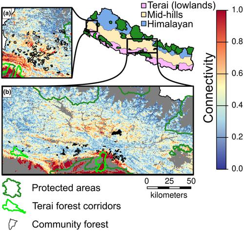
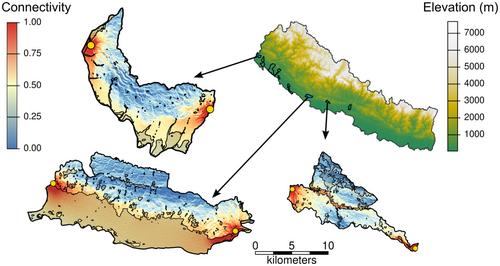
Enhancing habitat connectivity is a key strategy for conserving endangered species in anthropogenic landscapes. However, connectivity planning often overlooks the crucial energetic costs to animals of traversing complex terrains. We applied a novel approach for estimating energy costs of movement for tigers – a globally endangered species. We used those estimates to calculate landscape connectivity for these animals across the extreme altitudinal gradient of Nepal, where recent sightings of tigers at higher elevations (~3200 m) suggest an upward range expansion from the tiger-rich lowlands. To evaluate our estimates, we simulated tiger routes to higher-elevation locations and compared modeled energy costs of those ascents to those derived from a previous model calibrated with data from GPS-collared tigers in Russia. In areas below 3200 m, we found about 7.5 times greater land areas with high connectivity outside protected areas (~51 000 km2) than inside (~6800 km2). However, most of the highly connected areas below 3200 m consist of croplands (56%). Importantly, community-managed forests, which spanned the altitudinal gradient, tended to include areas with moderate levels of connectivity. Our estimates of energy costs and those from Russia showed a strong consensus (ρ = 0.70, P < 0.05), with ours better capturing the higher energy costs of traversing mountains and of very large total ascents. Our results show that while barriers to tiger movement across Nepal are ubiquitous, other effective area-based conservation measures (OECMs), like community-managed forests, can play prominent roles in promoting tiger habitat connectivity while minimizing human–tiger conflict across anthropogenic landscapes. Our results also underscore the utility of integrating first principles of energy efficiency into connectivity analyses and planning.
期刊介绍:
Animal Conservation provides a forum for rapid publication of novel, peer-reviewed research into the conservation of animal species and their habitats. The focus is on rigorous quantitative studies of an empirical or theoretical nature, which may relate to populations, species or communities and their conservation. We encourage the submission of single-species papers that have clear broader implications for conservation of other species or systems. A central theme is to publish important new ideas of broad interest and with findings that advance the scientific basis of conservation. Subjects covered include population biology, epidemiology, evolutionary ecology, population genetics, biodiversity, biogeography, palaeobiology and conservation economics.


 分享
分享
 求助内容:
求助内容: 应助结果提醒方式:
 扫码关注我们
