Xavier R. Nogueira, Gregory B. Pasternack, Belize A. Lane, Samuel Sandoval-Solis
{"title":"Width undulation drives flow convergence routing in five flashy ephemeral river types across a dry summer subtropical region","authors":"Xavier R. Nogueira, Gregory B. Pasternack, Belize A. Lane, Samuel Sandoval-Solis","doi":"10.1002/esp.5805","DOIUrl":null,"url":null,"abstract":"<p>During the last decade, meter-resolution topo-bathymetric digital elevation models (DEMs) have become increasingly utilized within fluvial geomorphology, but most meter-scale geomorphic analyses are done on just one to a few rivers. While such analyses have contributed greatly to our collective understanding of river discharge-topography interactions, which is applicable in both river restoration design and environmental flow regulation contexts, their generalizability across a range of river types remains largely unevaluated. This study assessed the dominance of a single hydro-morphodynamic mechanism, flow convergence routing, in 35 ephemeral rivers divided among five river types in California's South Coast region by answering five questions. Geomorphic covariance structure (GCS) analysis was performed on longitudinal standardized width and standardized, detrended bed elevation spatial series from meter-resolution DEMs. All river types had coherent, multi-scalar structures of longitudinal fluvial topography, implicating a process-morphology link. GCS metrics revealed that landform patterning was consistent with the requirements of the morphodynamic mechanism of flow convergence routing. Thus, that process was found to be a broadly relevant channel altering mechanism among sites, but its relationship with water stage differed between river types. Specifically, river types in unconfined valleys exhibited a strong bankfull width control over base flow bed undulations, with no obvious flood-stage control over bankfull landform patterning. River types in partially confined valleys also exhibited strong bankfull width control over base flow bed undulations, but their bankfull landform patterns appear to have coalesced with coherent width and bed elevation undulations during flood flows. Finally, metrics for confined river types showed that it takes higher magnitude, less frequent floods to set their coherent width and bed elevation undulations, but even these channels do exhibit flow convergence routing when given enough discharge for sufficient duration.</p>","PeriodicalId":11408,"journal":{"name":"Earth Surface Processes and Landforms","volume":"49 6","pages":"1890-1913"},"PeriodicalIF":2.7000,"publicationDate":"2024-03-07","publicationTypes":"Journal Article","fieldsOfStudy":null,"isOpenAccess":false,"openAccessPdf":"https://onlinelibrary.wiley.com/doi/epdf/10.1002/esp.5805","citationCount":"0","resultStr":null,"platform":"Semanticscholar","paperid":null,"PeriodicalName":"Earth Surface Processes and Landforms","FirstCategoryId":"89","ListUrlMain":"https://onlinelibrary.wiley.com/doi/10.1002/esp.5805","RegionNum":3,"RegionCategory":"地球科学","ArticlePicture":[],"TitleCN":null,"AbstractTextCN":null,"PMCID":null,"EPubDate":"","PubModel":"","JCR":"Q2","JCRName":"GEOGRAPHY, PHYSICAL","Score":null,"Total":0}
引用次数: 0
Abstract
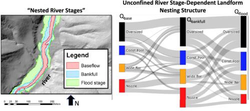
During the last decade, meter-resolution topo-bathymetric digital elevation models (DEMs) have become increasingly utilized within fluvial geomorphology, but most meter-scale geomorphic analyses are done on just one to a few rivers. While such analyses have contributed greatly to our collective understanding of river discharge-topography interactions, which is applicable in both river restoration design and environmental flow regulation contexts, their generalizability across a range of river types remains largely unevaluated. This study assessed the dominance of a single hydro-morphodynamic mechanism, flow convergence routing, in 35 ephemeral rivers divided among five river types in California's South Coast region by answering five questions. Geomorphic covariance structure (GCS) analysis was performed on longitudinal standardized width and standardized, detrended bed elevation spatial series from meter-resolution DEMs. All river types had coherent, multi-scalar structures of longitudinal fluvial topography, implicating a process-morphology link. GCS metrics revealed that landform patterning was consistent with the requirements of the morphodynamic mechanism of flow convergence routing. Thus, that process was found to be a broadly relevant channel altering mechanism among sites, but its relationship with water stage differed between river types. Specifically, river types in unconfined valleys exhibited a strong bankfull width control over base flow bed undulations, with no obvious flood-stage control over bankfull landform patterning. River types in partially confined valleys also exhibited strong bankfull width control over base flow bed undulations, but their bankfull landform patterns appear to have coalesced with coherent width and bed elevation undulations during flood flows. Finally, metrics for confined river types showed that it takes higher magnitude, less frequent floods to set their coherent width and bed elevation undulations, but even these channels do exhibit flow convergence routing when given enough discharge for sufficient duration.
在过去十年中,米分辨率地形-地下测深数字高程模型(DEM)在河川地貌学中的应用越来越广泛,但大多数米级地貌分析都是在一条或几条河流上进行的。虽然这些分析极大地促进了我们对河流排泄量与地形之间相互作用的集体理解,并适用于河流修复设计和环境流量调节,但它们在一系列河流类型中的普适性在很大程度上仍未得到评估。本研究通过回答五个问题,对加利福尼亚南海岸地区五种河流类型中 35 条短时河流的单一水文形态动力学机制--水流汇聚路由--的主导地位进行了评估。地貌协方差结构(GCS)分析是根据米分辨率 DEM 的纵向标准化宽度和标准化、去趋势河床高程空间序列进行的。所有河流类型的纵向河道地形都具有连贯的多尺度结构,这表明过程与形态之间存在联系。全球地形测量指标显示,地貌模式与水流汇聚路径的形态动力学机制要求一致。因此,该过程被认为是一个与不同地点的河道改变机制广泛相关的过程,但其与水位的关系却因河流类型而异。具体地说,非封闭河谷中的河流类型对基流河床起伏有很强的岸滩宽度控制,而对岸滩地貌形态没有明显的洪水阶段控制。部分封闭河谷中的河流类型也表现出对基流河床起伏的强岸宽控制,但它们的河岸地貌模式似乎与洪水期间的连贯宽度和河床高程起伏相一致。最后,封闭河流类型的度量指标显示,需要更大规模、更少频率的洪水才能形成连贯的宽度和河床高程起伏,但即使是这些河道,只要有足够大的流量和足够长的时间,也会表现出水流汇聚的路线。
期刊介绍:
Earth Surface Processes and Landforms is an interdisciplinary international journal concerned with:
the interactions between surface processes and landforms and landscapes;
that lead to physical, chemical and biological changes; and which in turn create;
current landscapes and the geological record of past landscapes.
Its focus is core to both physical geographical and geological communities, and also the wider geosciences


 分享
分享
 求助内容:
求助内容: 应助结果提醒方式:
 扫码关注我们
