Vittoria Scorpio, Andrea Andreoli, Nicola Dinkelaker, Enrico Marchese, Velio Coviello, Bernhard Gems, Gianluca Vignoli, Francesco Comiti
{"title":"Multi-decadal quantification of interactions between coarse sediment fluxes and channel management in South Tyrol, Eastern European Alps","authors":"Vittoria Scorpio, Andrea Andreoli, Nicola Dinkelaker, Enrico Marchese, Velio Coviello, Bernhard Gems, Gianluca Vignoli, Francesco Comiti","doi":"10.1002/esp.5804","DOIUrl":null,"url":null,"abstract":"<p>Channel incision and narrowing have occurred in the 20th century in most Alpine rivers. However, the causal links between sediment-related human engineering and exploitation and morphological changes in rivers are mostly unclear. This study presents an analysis of the evolutionary trajectories of the main active channels in the upper Etsch/Adige River basin (Eastern European Alps) coupled with their modifications in terms of coarse sediment transport. Channel planform variations were quantified in 15 rivers (total length of 630 km) using multi-temporal analysis of historical maps and orthophotos. Sediment volumes excavated from river channels or trapped by hydraulic structures (dams and retention basins) were retrieved from historical records, along with geospatial information regarding the presence of lateral and longitudinal consolidation works and land use variations. Results indicate that most rivers underwent slight narrowing and some of them experienced widening, from the mid-19th century to the 1950s. From the 1950s to the late 1990s, severe variations in terms of narrowing and morphological simplification took place in all rivers. The analysis of channel changes in relation to human activities shows that gravel mining carried out in the period 1970s–1990s appears to have been the main cause of sediment imbalance in the rivers which narrowed the most. Since the 2000s, when gravel mining was banned by law, channel adjustments have become negligible throughout study area. Nevertheless, the trapping of a large share of coarse sediment fluxes—at the river basin scale—by retention check dams and hydropower dams has impeded rivers from recovering to their original conditions.</p>","PeriodicalId":11408,"journal":{"name":"Earth Surface Processes and Landforms","volume":"49 6","pages":"1869-1889"},"PeriodicalIF":2.7000,"publicationDate":"2024-03-11","publicationTypes":"Journal Article","fieldsOfStudy":null,"isOpenAccess":false,"openAccessPdf":"","citationCount":"0","resultStr":null,"platform":"Semanticscholar","paperid":null,"PeriodicalName":"Earth Surface Processes and Landforms","FirstCategoryId":"89","ListUrlMain":"https://onlinelibrary.wiley.com/doi/10.1002/esp.5804","RegionNum":3,"RegionCategory":"地球科学","ArticlePicture":[],"TitleCN":null,"AbstractTextCN":null,"PMCID":null,"EPubDate":"","PubModel":"","JCR":"Q2","JCRName":"GEOGRAPHY, PHYSICAL","Score":null,"Total":0}
引用次数: 0
Abstract
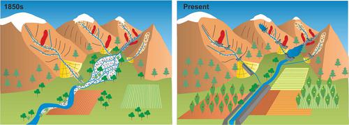
Channel incision and narrowing have occurred in the 20th century in most Alpine rivers. However, the causal links between sediment-related human engineering and exploitation and morphological changes in rivers are mostly unclear. This study presents an analysis of the evolutionary trajectories of the main active channels in the upper Etsch/Adige River basin (Eastern European Alps) coupled with their modifications in terms of coarse sediment transport. Channel planform variations were quantified in 15 rivers (total length of 630 km) using multi-temporal analysis of historical maps and orthophotos. Sediment volumes excavated from river channels or trapped by hydraulic structures (dams and retention basins) were retrieved from historical records, along with geospatial information regarding the presence of lateral and longitudinal consolidation works and land use variations. Results indicate that most rivers underwent slight narrowing and some of them experienced widening, from the mid-19th century to the 1950s. From the 1950s to the late 1990s, severe variations in terms of narrowing and morphological simplification took place in all rivers. The analysis of channel changes in relation to human activities shows that gravel mining carried out in the period 1970s–1990s appears to have been the main cause of sediment imbalance in the rivers which narrowed the most. Since the 2000s, when gravel mining was banned by law, channel adjustments have become negligible throughout study area. Nevertheless, the trapping of a large share of coarse sediment fluxes—at the river basin scale—by retention check dams and hydropower dams has impeded rivers from recovering to their original conditions.
期刊介绍:
Earth Surface Processes and Landforms is an interdisciplinary international journal concerned with:
the interactions between surface processes and landforms and landscapes;
that lead to physical, chemical and biological changes; and which in turn create;
current landscapes and the geological record of past landscapes.
Its focus is core to both physical geographical and geological communities, and also the wider geosciences


 分享
分享
 求助内容:
求助内容: 应助结果提醒方式:
 扫码关注我们
