{"title":"Simulation of topographic effects on soil erosion and deposition in a small watershed of loess hilly region","authors":"Zhihong Yao, Yiwen Zhang, Qinke Yang, Lu Zhang, Lingling Wang, Dongbao Zhao","doi":"10.1002/esp.5801","DOIUrl":null,"url":null,"abstract":"<p>Topography plays a critical role in soil migration and redistribution, but few studies have been conducted to quantify its effects on sediment deposition. In this study, we established a physical simulation and analysis framework to investigate the erosional and depositional impacts of two-dimensional slope terrain, specifically applied to Xiannangou small watershed in the loess hilly region. The results showed that the slope gradient, slope length, and slope shape have significantly influence the distribution of soil erosion and deposition. The magnitude of the erosion/deposition rate (<i>Y</i><sub><i>r</i></sub>) determines the relative intensity of slope erosion and deposition, where <i>Y</i><sub><i>r</i></sub> < 0 indicates erosion and <i>Y</i><sub><i>r</i></sub> > 0 signifies deposition. The erosion rate on straight slope exhibited a positive correlation with slope length, while the erosion/deposition rate on concave and convex slopes exhibited fluctuations with slope length. Soil erosion predominantly occurred along the main flow line and the middle slope, aligning with the observed distribution of gully and slope erosion in the field. The sediment deposition was primarily concentrated on the lower slope or the lowest outlet of the basin, notably in gullies and gentle slopes where the terrain slows, especially during transition from steep to gradual slopes. These results can effectively predict the relative erosion/sedimentation rate of two-dimensional slopes, significantly contributing to a comprehensive understanding of how topography influences soil erosion and deposition. This study thoroughly considers the role of sediment deposition in the soil erosion process, providing a more accurate reflection of soil erosion/deposition in small watersheds. It addresses the existing deficiency in sediment consideration within soil erosion evaluation and supports the enhancement of soil erosion model.</p>","PeriodicalId":11408,"journal":{"name":"Earth Surface Processes and Landforms","volume":"49 6","pages":"1836-1848"},"PeriodicalIF":2.7000,"publicationDate":"2024-03-26","publicationTypes":"Journal Article","fieldsOfStudy":null,"isOpenAccess":false,"openAccessPdf":"","citationCount":"0","resultStr":null,"platform":"Semanticscholar","paperid":null,"PeriodicalName":"Earth Surface Processes and Landforms","FirstCategoryId":"89","ListUrlMain":"https://onlinelibrary.wiley.com/doi/10.1002/esp.5801","RegionNum":3,"RegionCategory":"地球科学","ArticlePicture":[],"TitleCN":null,"AbstractTextCN":null,"PMCID":null,"EPubDate":"","PubModel":"","JCR":"Q2","JCRName":"GEOGRAPHY, PHYSICAL","Score":null,"Total":0}
引用次数: 0
Abstract
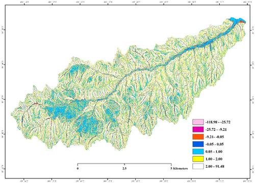
Topography plays a critical role in soil migration and redistribution, but few studies have been conducted to quantify its effects on sediment deposition. In this study, we established a physical simulation and analysis framework to investigate the erosional and depositional impacts of two-dimensional slope terrain, specifically applied to Xiannangou small watershed in the loess hilly region. The results showed that the slope gradient, slope length, and slope shape have significantly influence the distribution of soil erosion and deposition. The magnitude of the erosion/deposition rate (Yr) determines the relative intensity of slope erosion and deposition, where Yr < 0 indicates erosion and Yr > 0 signifies deposition. The erosion rate on straight slope exhibited a positive correlation with slope length, while the erosion/deposition rate on concave and convex slopes exhibited fluctuations with slope length. Soil erosion predominantly occurred along the main flow line and the middle slope, aligning with the observed distribution of gully and slope erosion in the field. The sediment deposition was primarily concentrated on the lower slope or the lowest outlet of the basin, notably in gullies and gentle slopes where the terrain slows, especially during transition from steep to gradual slopes. These results can effectively predict the relative erosion/sedimentation rate of two-dimensional slopes, significantly contributing to a comprehensive understanding of how topography influences soil erosion and deposition. This study thoroughly considers the role of sediment deposition in the soil erosion process, providing a more accurate reflection of soil erosion/deposition in small watersheds. It addresses the existing deficiency in sediment consideration within soil erosion evaluation and supports the enhancement of soil erosion model.
期刊介绍:
Earth Surface Processes and Landforms is an interdisciplinary international journal concerned with:
the interactions between surface processes and landforms and landscapes;
that lead to physical, chemical and biological changes; and which in turn create;
current landscapes and the geological record of past landscapes.
Its focus is core to both physical geographical and geological communities, and also the wider geosciences


 分享
分享
 求助内容:
求助内容: 应助结果提醒方式:
 扫码关注我们
