{"title":"Multi-model seismic susceptibility assessment of the 1950 great Assam earthquake in the Eastern Himalayan front","authors":"Arun Bhadran , B.P. Duarah , Drishya Girishbai , A.L. Achu , Sandeep Lahon , N.P. Jesiya , V.K. Vijesh , Girish Gopinath","doi":"10.1016/j.geogeo.2024.100270","DOIUrl":null,"url":null,"abstract":"<div><p>The seismic susceptibility and mitigation management is paramount concern in tectonically active area like Northeastern India. This area has been devastated innumerably during the 1950 Assam great earthquake. The present study area falls in the foreland basin (Brahmaputra Valley) of Eastern Himalaya. This region is seismically vulnerable due to the tectonic complexity caused by the convergence of the Eurasian, Indian, and Burmese plates. In such, an area optimal disaster management and preparedness is necessary to define the non-linear character of seismic susceptibility, where population and unscientific urbanization have increased manifold. Therefore, for the present study, various multi-criteria decision making (MCDM) methods such as analytical hierarchy process (AHP), fuzzy-AHP (FAHP), and maximum entropy technique (MaxEnt) have been used for determining the seismic susceptibility, by assigning weightage to nine controlling factors such as: predominant frequency (f0), geology (G), vulnerability index (K), peak amplification (A0), liquefaction potential (LP), groundwater condition (WT), shear wave velocity (Vs30), peak ground acceleration (PGA), and land use/land cover (LU). The MaxEnt model exhibits the highest accuracy (87.5%) when the performance of the models was compared using the receiver operating characteristic curve (ROC) and area under the curve (AUC) value. Further, overlay analysis of best seismic susceptibility model using MaxEnt and PGV-based Japan Meteorological Agency (JMA) intensity shows that 40% the study area is in the very high and high seismic risk zone. In tectonically active areas, this kind of integration work is essential to improves the mitigation strategy and aids urban planners in designing earthquake-resistant buildings.</p></div>","PeriodicalId":100582,"journal":{"name":"Geosystems and Geoenvironment","volume":"3 3","pages":"Article 100270"},"PeriodicalIF":0.0000,"publicationDate":"2024-08-01","publicationTypes":"Journal Article","fieldsOfStudy":null,"isOpenAccess":false,"openAccessPdf":"https://www.sciencedirect.com/science/article/pii/S2772883824000207/pdfft?md5=768e66aae11cae85611c3754ce2b30b9&pid=1-s2.0-S2772883824000207-main.pdf","citationCount":"0","resultStr":null,"platform":"Semanticscholar","paperid":null,"PeriodicalName":"Geosystems and Geoenvironment","FirstCategoryId":"1085","ListUrlMain":"https://www.sciencedirect.com/science/article/pii/S2772883824000207","RegionNum":0,"RegionCategory":null,"ArticlePicture":[],"TitleCN":null,"AbstractTextCN":null,"PMCID":null,"EPubDate":"2024/3/17 0:00:00","PubModel":"Epub","JCR":"","JCRName":"","Score":null,"Total":0}
引用次数: 0
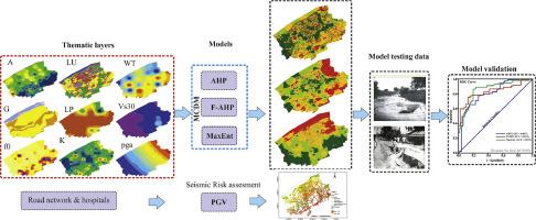
Abstract
The seismic susceptibility and mitigation management is paramount concern in tectonically active area like Northeastern India. This area has been devastated innumerably during the 1950 Assam great earthquake. The present study area falls in the foreland basin (Brahmaputra Valley) of Eastern Himalaya. This region is seismically vulnerable due to the tectonic complexity caused by the convergence of the Eurasian, Indian, and Burmese plates. In such, an area optimal disaster management and preparedness is necessary to define the non-linear character of seismic susceptibility, where population and unscientific urbanization have increased manifold. Therefore, for the present study, various multi-criteria decision making (MCDM) methods such as analytical hierarchy process (AHP), fuzzy-AHP (FAHP), and maximum entropy technique (MaxEnt) have been used for determining the seismic susceptibility, by assigning weightage to nine controlling factors such as: predominant frequency (f0), geology (G), vulnerability index (K), peak amplification (A0), liquefaction potential (LP), groundwater condition (WT), shear wave velocity (Vs30), peak ground acceleration (PGA), and land use/land cover (LU). The MaxEnt model exhibits the highest accuracy (87.5%) when the performance of the models was compared using the receiver operating characteristic curve (ROC) and area under the curve (AUC) value. Further, overlay analysis of best seismic susceptibility model using MaxEnt and PGV-based Japan Meteorological Agency (JMA) intensity shows that 40% the study area is in the very high and high seismic risk zone. In tectonically active areas, this kind of integration work is essential to improves the mitigation strategy and aids urban planners in designing earthquake-resistant buildings.


 分享
分享

 求助内容:
求助内容: 应助结果提醒方式:
 扫码关注我们
