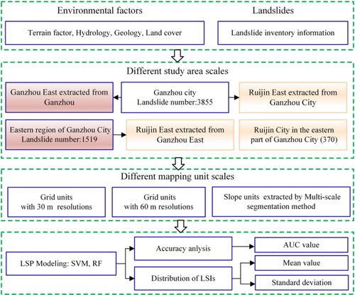
{"title":"Uncertainties of landslide susceptibility prediction: influences of different study area scales and mapping unit scales","authors":"Faming Huang, Yu Cao, Wenbin Li, Filippo Catani, Guquan Song, Jinsong Huang, Changshi Yu","doi":"10.1007/s40789-024-00678-w","DOIUrl":null,"url":null,"abstract":"<h3 data-test=\"abstract-sub-heading\">Abstract</h3><p>This study aims to investigate the effects of different mapping unit scales and study area scales on the uncertainty rules of landslide susceptibility prediction (LSP). To illustrate various study area scales, Ganzhou City in China, its eastern region (Ganzhou East), and Ruijin County in Ganzhou East were chosen. Different mapping unit scales are represented by grid units with spatial resolution of 30 and 60 m, as well as slope units that were extracted by multi-scale segmentation method. The 3855 landslide locations and 21 typical environmental factors in Ganzhou City are first determined to create spatial datasets with input-outputs. Then, landslide susceptibility maps (LSMs) of Ganzhou City, Ganzhou East and Ruijin County are produced using a support vector machine (SVM) and random forest (RF), respectively. The LSMs of the above three regions are then extracted by mask from the LSM of Ganzhou City, along with the LSMs of Ruijin County from Ganzhou East. Additionally, LSMs of Ruijin at various mapping unit scales are generated in accordance. Accuracy and landslide susceptibility indexes (LSIs) distribution are used to express LSP uncertainties. The LSP uncertainties under grid units significantly decrease as study area scales decrease from Ganzhou City, Ganzhou East to Ruijin County, whereas those under slope units are less affected by study area scales. Of course, attentions should also be paid to the broader representativeness of large study areas. The LSP accuracy of slope units increases by about 6%–10% compared with those under grid units with 30 m and 60 m resolution in the same study area's scale. The significance of environmental factors exhibits an averaging trend as study area scale increases from small to large. The importance of environmental factors varies greatly with the 60 m grid unit, but it tends to be consistent to some extent in the 30 m grid unit and the slope unit.</p><h3 data-test=\"abstract-sub-heading\">Graphic abstract</h3>","PeriodicalId":53469,"journal":{"name":"International Journal of Coal Science & Technology","volume":"51 1","pages":""},"PeriodicalIF":8.7000,"publicationDate":"2024-04-05","publicationTypes":"Journal Article","fieldsOfStudy":null,"isOpenAccess":false,"openAccessPdf":"","citationCount":"0","resultStr":null,"platform":"Semanticscholar","paperid":null,"PeriodicalName":"International Journal of Coal Science & Technology","FirstCategoryId":"5","ListUrlMain":"https://doi.org/10.1007/s40789-024-00678-w","RegionNum":1,"RegionCategory":"工程技术","ArticlePicture":[],"TitleCN":null,"AbstractTextCN":null,"PMCID":null,"EPubDate":"","PubModel":"","JCR":"Q2","JCRName":"ENERGY & FUELS","Score":null,"Total":0}
引用次数: 0
Abstract
This study aims to investigate the effects of different mapping unit scales and study area scales on the uncertainty rules of landslide susceptibility prediction (LSP). To illustrate various study area scales, Ganzhou City in China, its eastern region (Ganzhou East), and Ruijin County in Ganzhou East were chosen. Different mapping unit scales are represented by grid units with spatial resolution of 30 and 60 m, as well as slope units that were extracted by multi-scale segmentation method. The 3855 landslide locations and 21 typical environmental factors in Ganzhou City are first determined to create spatial datasets with input-outputs. Then, landslide susceptibility maps (LSMs) of Ganzhou City, Ganzhou East and Ruijin County are produced using a support vector machine (SVM) and random forest (RF), respectively. The LSMs of the above three regions are then extracted by mask from the LSM of Ganzhou City, along with the LSMs of Ruijin County from Ganzhou East. Additionally, LSMs of Ruijin at various mapping unit scales are generated in accordance. Accuracy and landslide susceptibility indexes (LSIs) distribution are used to express LSP uncertainties. The LSP uncertainties under grid units significantly decrease as study area scales decrease from Ganzhou City, Ganzhou East to Ruijin County, whereas those under slope units are less affected by study area scales. Of course, attentions should also be paid to the broader representativeness of large study areas. The LSP accuracy of slope units increases by about 6%–10% compared with those under grid units with 30 m and 60 m resolution in the same study area's scale. The significance of environmental factors exhibits an averaging trend as study area scale increases from small to large. The importance of environmental factors varies greatly with the 60 m grid unit, but it tends to be consistent to some extent in the 30 m grid unit and the slope unit.
期刊介绍:
The International Journal of Coal Science & Technology is a peer-reviewed open access journal that focuses on key topics of coal scientific research and mining development. It serves as a forum for scientists to present research findings and discuss challenging issues in the field.
The journal covers a range of topics including coal geology, geochemistry, geophysics, mineralogy, and petrology. It also covers coal mining theory, technology, and engineering, as well as coal processing, utilization, and conversion. Additionally, the journal explores coal mining environment and reclamation, along with related aspects.
The International Journal of Coal Science & Technology is published with China Coal Society, who also cover the publication costs. This means that authors do not need to pay an article-processing charge.


 分享
分享
 求助内容:
求助内容: 应助结果提醒方式:
 扫码关注我们
