{"title":"A study on the urban growth and dynamics over 16 major cities of India","authors":"Asmita Mukherjee, Jagabandhu Panda","doi":"10.1007/s12040-024-02280-9","DOIUrl":null,"url":null,"abstract":"<p>Urban agglomerations across the world have witnessed haphazard and unprecedented growth in the recent past, giving rise to urban sprawling. This study analyses the spatio-temporal growth dynamics of 16 major Indian cities (population above one million) using remote sensing approaches. Land Use and Land Cover (LULC) thematic datasets are considered for the years 2005, 2010, 2015, and 2021. The variability of the five LULC classes, viz., urban built-up, vegetation, water body, agriculture, and barren land, implied that urban expansion mostly took place at the cost of barren lands. The urbanised landscape mainly portrayed dispersive outward growth since the beginning of the 21st century, with significant compaction (infill urban growth) near the urban core in recent years. The results derived through Shannon’s Entropy, spatial metrics, and urban density gradient analysis (in eight directions) indicated the same. Population density variation with respect to the horizontal urban growth and dynamics in each considered direction, further supported the concept of overcrowded city centres and sprawled outskirts. Besides population density, other factors that could be associated with urbanisation include the local environment, meteorology, and some geophysical characteristics.</p>","PeriodicalId":15609,"journal":{"name":"Journal of Earth System Science","volume":"92 1","pages":""},"PeriodicalIF":1.7000,"publicationDate":"2024-04-04","publicationTypes":"Journal Article","fieldsOfStudy":null,"isOpenAccess":false,"openAccessPdf":"","citationCount":"0","resultStr":null,"platform":"Semanticscholar","paperid":null,"PeriodicalName":"Journal of Earth System Science","FirstCategoryId":"89","ListUrlMain":"https://doi.org/10.1007/s12040-024-02280-9","RegionNum":4,"RegionCategory":"地球科学","ArticlePicture":[],"TitleCN":null,"AbstractTextCN":null,"PMCID":null,"EPubDate":"","PubModel":"","JCR":"Q3","JCRName":"GEOSCIENCES, MULTIDISCIPLINARY","Score":null,"Total":0}
引用次数: 0
Abstract
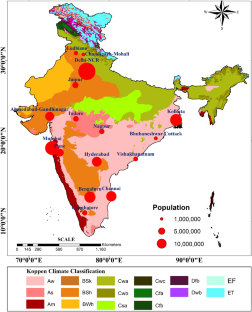
Urban agglomerations across the world have witnessed haphazard and unprecedented growth in the recent past, giving rise to urban sprawling. This study analyses the spatio-temporal growth dynamics of 16 major Indian cities (population above one million) using remote sensing approaches. Land Use and Land Cover (LULC) thematic datasets are considered for the years 2005, 2010, 2015, and 2021. The variability of the five LULC classes, viz., urban built-up, vegetation, water body, agriculture, and barren land, implied that urban expansion mostly took place at the cost of barren lands. The urbanised landscape mainly portrayed dispersive outward growth since the beginning of the 21st century, with significant compaction (infill urban growth) near the urban core in recent years. The results derived through Shannon’s Entropy, spatial metrics, and urban density gradient analysis (in eight directions) indicated the same. Population density variation with respect to the horizontal urban growth and dynamics in each considered direction, further supported the concept of overcrowded city centres and sprawled outskirts. Besides population density, other factors that could be associated with urbanisation include the local environment, meteorology, and some geophysical characteristics.
期刊介绍:
The Journal of Earth System Science, an International Journal, was earlier a part of the Proceedings of the Indian Academy of Sciences – Section A begun in 1934, and later split in 1978 into theme journals. This journal was published as Proceedings – Earth and Planetary Sciences since 1978, and in 2005 was renamed ‘Journal of Earth System Science’.
The journal is highly inter-disciplinary and publishes scholarly research – new data, ideas, and conceptual advances – in Earth System Science. The focus is on the evolution of the Earth as a system: manuscripts describing changes of anthropogenic origin in a limited region are not considered unless they go beyond describing the changes to include an analysis of earth-system processes. The journal''s scope includes the solid earth (geosphere), the atmosphere, the hydrosphere (including cryosphere), and the biosphere; it also addresses related aspects of planetary and space sciences. Contributions pertaining to the Indian sub- continent and the surrounding Indian-Ocean region are particularly welcome. Given that a large number of manuscripts report either observations or model results for a limited domain, manuscripts intended for publication in JESS are expected to fulfill at least one of the following three criteria.
The data should be of relevance and should be of statistically significant size and from a region from where such data are sparse. If the data are from a well-sampled region, the data size should be considerable and advance our knowledge of the region.
A model study is carried out to explain observations reported either in the same manuscript or in the literature.
The analysis, whether of data or with models, is novel and the inferences advance the current knowledge.


 分享
分享
 求助内容:
求助内容: 应助结果提醒方式:
 扫码关注我们
