Elowyn M. Yager, Jaeho Shim, Rebecca Hodge, Angel Monsalve, Daniele Tonina, Joel P. L. Johnson, Luke Telfer
{"title":"Pro+: Automated protrusion and critical shear stress estimates from 3D point clouds of gravel beds","authors":"Elowyn M. Yager, Jaeho Shim, Rebecca Hodge, Angel Monsalve, Daniele Tonina, Joel P. L. Johnson, Luke Telfer","doi":"10.1002/esp.5822","DOIUrl":null,"url":null,"abstract":"<p>The dimensionless critical shear stress (<i>τ</i>*<sub>c</sub>) needed for the onset of sediment motion is important for a range of studies from river restoration projects to landscape evolution calculations. Many studies simply assume a <i>τ</i>*<sub>c</sub> value within the large range of scatter observed in gravel-bedded rivers because direct field estimates are difficult to obtain. Informed choices of reach-scale <i>τ</i>*<sub>c</sub> values could instead be obtained from force balance calculations that include particle-scale bed structure and flow conditions. Particle-scale bed structure is also difficult to measure, precluding wide adoption of such force-balance <i>τ</i>*<sub>c</sub> values. Recent studies have demonstrated that bed grain size distributions (GSD) can be determined from detailed point clouds (e.g. using G3Point open-source software). We build on these point cloud methods to introduce Pro+, software that estimates particle-scale protrusion distributions and <i>τ</i>*<sub>c</sub> for each grain size and for the entire bed using a force-balance model. We validated G3Point and Pro+ using two laboratory flume experiments with different grain size distributions and bed topographies. Commonly used definitions of protrusion may not produce representative <i>τ</i>*<sub>c</sub> distributions, and Pro+ includes new protrusion definitions to better include flow and bed structure influences on particle mobility. The combined G3Point/Pro+ provided accurate grain size, protrusion and <i>τ</i>*<sub>c</sub> distributions with simple GSD calibration. The largest source of error in protrusion and <i>τ</i>*<sub>c</sub> distributions were from incorrect grain boundaries and grain locations in G3Point, and calibration of grain software beyond comparing GSD is likely needed. Pro+ can be coupled with grain identifying software and relatively easily obtainable data to provide informed estimates of <i>τ</i>*<sub>c</sub>. These could replace arbitrary choices of <i>τ</i>*<sub>c</sub> and potentially improve channel stability and sediment transport estimates.</p>","PeriodicalId":11408,"journal":{"name":"Earth Surface Processes and Landforms","volume":"49 7","pages":"2155-2170"},"PeriodicalIF":2.7000,"publicationDate":"2024-04-04","publicationTypes":"Journal Article","fieldsOfStudy":null,"isOpenAccess":false,"openAccessPdf":"","citationCount":"0","resultStr":null,"platform":"Semanticscholar","paperid":null,"PeriodicalName":"Earth Surface Processes and Landforms","FirstCategoryId":"89","ListUrlMain":"https://onlinelibrary.wiley.com/doi/10.1002/esp.5822","RegionNum":3,"RegionCategory":"地球科学","ArticlePicture":[],"TitleCN":null,"AbstractTextCN":null,"PMCID":null,"EPubDate":"","PubModel":"","JCR":"Q2","JCRName":"GEOGRAPHY, PHYSICAL","Score":null,"Total":0}
引用次数: 0
Abstract
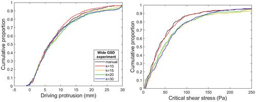
The dimensionless critical shear stress (τ*c) needed for the onset of sediment motion is important for a range of studies from river restoration projects to landscape evolution calculations. Many studies simply assume a τ*c value within the large range of scatter observed in gravel-bedded rivers because direct field estimates are difficult to obtain. Informed choices of reach-scale τ*c values could instead be obtained from force balance calculations that include particle-scale bed structure and flow conditions. Particle-scale bed structure is also difficult to measure, precluding wide adoption of such force-balance τ*c values. Recent studies have demonstrated that bed grain size distributions (GSD) can be determined from detailed point clouds (e.g. using G3Point open-source software). We build on these point cloud methods to introduce Pro+, software that estimates particle-scale protrusion distributions and τ*c for each grain size and for the entire bed using a force-balance model. We validated G3Point and Pro+ using two laboratory flume experiments with different grain size distributions and bed topographies. Commonly used definitions of protrusion may not produce representative τ*c distributions, and Pro+ includes new protrusion definitions to better include flow and bed structure influences on particle mobility. The combined G3Point/Pro+ provided accurate grain size, protrusion and τ*c distributions with simple GSD calibration. The largest source of error in protrusion and τ*c distributions were from incorrect grain boundaries and grain locations in G3Point, and calibration of grain software beyond comparing GSD is likely needed. Pro+ can be coupled with grain identifying software and relatively easily obtainable data to provide informed estimates of τ*c. These could replace arbitrary choices of τ*c and potentially improve channel stability and sediment transport estimates.
期刊介绍:
Earth Surface Processes and Landforms is an interdisciplinary international journal concerned with:
the interactions between surface processes and landforms and landscapes;
that lead to physical, chemical and biological changes; and which in turn create;
current landscapes and the geological record of past landscapes.
Its focus is core to both physical geographical and geological communities, and also the wider geosciences


 分享
分享
 求助内容:
求助内容: 应助结果提醒方式:
 扫码关注我们
