{"title":"Intensively Cultivated Roman Villae Estates: Case Study of Medulin Bay (Istria, Croatia)","authors":"Nives Doneus, Michael Doneus","doi":"10.1002/arp.1933","DOIUrl":null,"url":null,"abstract":"<p>Our image of the Roman landscape of Istria is characterised by large-scale centuriation and architectural remains of Roman villae. Detection and mapping of other, less dramatic landscape features require systematic large-scale prospection, but this faces significant difficulties in the Mediterranean environment. However, the developments in the field of airborne laser scanning offer the possibility to create archaeologically usable digital terrain models under water and under very dense and low maquis vegetation. This paper reports on the use of terrain models created using a green laser and a sophisticated archaeologically driven ground point filtering strategy. Combined with archaeological aerial photo interpretation, this provides the means for landscape mapping and interpretation that has revealed a wealth of archaeological structures hinting at Roman agricultural practices and landscape. Our case study is based on a laser scan of about 24 km<sup>2</sup> of land and underwater terrain in Medulin Bay. Processed, visualised and interpreted for archaeological purposes, the data reveal not only features ranging from prehistoric hilltop settlements to modern military installations but also features a complex picture of the Roman land use. Of particular interest is the large number of planting pits, which extend over a total length of 4 km. They were laid on a regular grid of approximately 35 × 35 m, sometimes combined in contiguous parcels. They can be interpreted as remains of orchards or tree nurseries of Roman date, and the paper examines also the question of whether they can be linked to the associated Roman estates. The case study area presented here shows that the potential of remote sensing methods goes far beyond the mere finding of traditional sites but can open up new landscape-scale perspectives on regions that have been archaeologically little explored.</p>","PeriodicalId":55490,"journal":{"name":"Archaeological Prospection","volume":"31 2","pages":"75-97"},"PeriodicalIF":1.9000,"publicationDate":"2024-04-24","publicationTypes":"Journal Article","fieldsOfStudy":null,"isOpenAccess":false,"openAccessPdf":"https://onlinelibrary.wiley.com/doi/epdf/10.1002/arp.1933","citationCount":"0","resultStr":null,"platform":"Semanticscholar","paperid":null,"PeriodicalName":"Archaeological Prospection","FirstCategoryId":"89","ListUrlMain":"https://onlinelibrary.wiley.com/doi/10.1002/arp.1933","RegionNum":3,"RegionCategory":"地球科学","ArticlePicture":[],"TitleCN":null,"AbstractTextCN":null,"PMCID":null,"EPubDate":"","PubModel":"","JCR":"0","JCRName":"ARCHAEOLOGY","Score":null,"Total":0}
引用次数: 0
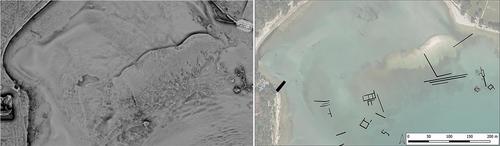
Abstract
Our image of the Roman landscape of Istria is characterised by large-scale centuriation and architectural remains of Roman villae. Detection and mapping of other, less dramatic landscape features require systematic large-scale prospection, but this faces significant difficulties in the Mediterranean environment. However, the developments in the field of airborne laser scanning offer the possibility to create archaeologically usable digital terrain models under water and under very dense and low maquis vegetation. This paper reports on the use of terrain models created using a green laser and a sophisticated archaeologically driven ground point filtering strategy. Combined with archaeological aerial photo interpretation, this provides the means for landscape mapping and interpretation that has revealed a wealth of archaeological structures hinting at Roman agricultural practices and landscape. Our case study is based on a laser scan of about 24 km2 of land and underwater terrain in Medulin Bay. Processed, visualised and interpreted for archaeological purposes, the data reveal not only features ranging from prehistoric hilltop settlements to modern military installations but also features a complex picture of the Roman land use. Of particular interest is the large number of planting pits, which extend over a total length of 4 km. They were laid on a regular grid of approximately 35 × 35 m, sometimes combined in contiguous parcels. They can be interpreted as remains of orchards or tree nurseries of Roman date, and the paper examines also the question of whether they can be linked to the associated Roman estates. The case study area presented here shows that the potential of remote sensing methods goes far beyond the mere finding of traditional sites but can open up new landscape-scale perspectives on regions that have been archaeologically little explored.
期刊介绍:
The scope of the Journal will be international, covering urban, rural and marine environments and the full range of underlying geology.
The Journal will contain articles relating to the use of a wide range of propecting techniques, including remote sensing (airborne and satellite), geophysical (e.g. resistivity, magnetometry) and geochemical (e.g. organic markers, soil phosphate). Reports and field evaluations of new techniques will be welcomed.
Contributions will be encouraged on the application of relevant software, including G.I.S. analysis, to the data derived from prospection techniques and cartographic analysis of early maps.
Reports on integrated site evaluations and follow-up site investigations will be particularly encouraged.
The Journal will welcome contributions, in the form of short (field) reports, on the application of prospection techniques in support of comprehensive land-use studies.
The Journal will, as appropriate, contain book reviews, conference and meeting reviews, and software evaluation.
All papers will be subjected to peer review.


 分享
分享
 求助内容:
求助内容: 应助结果提醒方式:
 扫码关注我们
