Xiaoye Tong, Xiaoxin Zhang, Rasmus Fensholt, Peter Rosendal Dau Jensen, Sizhuo Li, Marianne Nylandsted Larsen, Florian Reiner, Feng Tian, Martin Brandt
{"title":"Global area boom for greenhouse cultivation revealed by satellite mapping","authors":"Xiaoye Tong, Xiaoxin Zhang, Rasmus Fensholt, Peter Rosendal Dau Jensen, Sizhuo Li, Marianne Nylandsted Larsen, Florian Reiner, Feng Tian, Martin Brandt","doi":"10.1038/s43016-024-00985-0","DOIUrl":null,"url":null,"abstract":"Greenhouse cultivation has been expanding rapidly in recent years, yet little knowledge exists on its global extent and expansion. Using commercial and freely available satellite data combined with artificial intelligence techniques, we present a global assessment of greenhouse cultivation coverage and map 1.3 million hectares of greenhouse infrastructures in 2019, a much larger extent than previously estimated. Our analysis includes both large (61%) and small-scale (39%) greenhouse infrastructures. Examining the temporal development of the 65 largest clusters (>1,500 ha), we show a recent upsurge in greenhouse cultivation in the Global South since the 2000s, including a dramatic increase in China, accounting for 60% of the global coverage. We emphasize the potential of greenhouse infrastructures to enhance food security but raise awareness of the uncertain environmental and social implications that may arise from this expansion. We further highlight the gap in spatio-temporal datasets for supporting future research agendas on this critical topic. Greenhouses are quickly proliferating in response to the world’s increasing demand for food, but information on their precise location, distribution and extent remains limited in many countries. This Analysis combines global very-high-resolution satellite imagery and artificial intelligence to address this knowledge gap, showing a dramatic increase in greenhouse coverage in the Global South.","PeriodicalId":94151,"journal":{"name":"Nature food","volume":"5 6","pages":"513-523"},"PeriodicalIF":21.9000,"publicationDate":"2024-05-13","publicationTypes":"Journal Article","fieldsOfStudy":null,"isOpenAccess":false,"openAccessPdf":"","citationCount":"0","resultStr":null,"platform":"Semanticscholar","paperid":null,"PeriodicalName":"Nature food","FirstCategoryId":"1085","ListUrlMain":"https://www.nature.com/articles/s43016-024-00985-0","RegionNum":0,"RegionCategory":null,"ArticlePicture":[],"TitleCN":null,"AbstractTextCN":null,"PMCID":null,"EPubDate":"","PubModel":"","JCR":"Q1","JCRName":"FOOD SCIENCE & TECHNOLOGY","Score":null,"Total":0}
引用次数: 0
Abstract
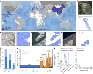
Greenhouse cultivation has been expanding rapidly in recent years, yet little knowledge exists on its global extent and expansion. Using commercial and freely available satellite data combined with artificial intelligence techniques, we present a global assessment of greenhouse cultivation coverage and map 1.3 million hectares of greenhouse infrastructures in 2019, a much larger extent than previously estimated. Our analysis includes both large (61%) and small-scale (39%) greenhouse infrastructures. Examining the temporal development of the 65 largest clusters (>1,500 ha), we show a recent upsurge in greenhouse cultivation in the Global South since the 2000s, including a dramatic increase in China, accounting for 60% of the global coverage. We emphasize the potential of greenhouse infrastructures to enhance food security but raise awareness of the uncertain environmental and social implications that may arise from this expansion. We further highlight the gap in spatio-temporal datasets for supporting future research agendas on this critical topic. Greenhouses are quickly proliferating in response to the world’s increasing demand for food, but information on their precise location, distribution and extent remains limited in many countries. This Analysis combines global very-high-resolution satellite imagery and artificial intelligence to address this knowledge gap, showing a dramatic increase in greenhouse coverage in the Global South.


 分享
分享

 求助内容:
求助内容: 应助结果提醒方式:
 扫码关注我们
