{"title":"Evolution of riverbed morphology in a main-stem river due to management of sediment source areas","authors":"Cheng Yang, Zaizhi Yang, Ronghua Zhong, Jiangcheng Huang, Xinbao Zhang, Yang Cheng","doi":"10.1002/esp.5867","DOIUrl":null,"url":null,"abstract":"<p>The evolution of riverbeds is greatly impacted by changes in the water–sediment relationship resulting from the movement of debris flows. However, little is known about the influence of management in chronic sediment source areas on the evolution of main-stem riverbed morphology. In this study, we used multi-source remote sensing images covering the past 50 years along with water–sediment and topographic data from a river basin, and sediment transport data from debris flows, to analyze the evolutionary processes of the middle and lower reaches of the Daying River (DYR) at the China-Myanmar border. Our results showed that (1) management of the sediment source area shifted the riverbed morphology from aggradation to erosion, transforming the river surface from wide and shallow to narrow and deep, and the channel from multi-threaded to single-threaded; (2) the active alluvial area, marginal bar area, and average river width exhibited an inverted V-shaped trend, increasing by at least 23% and then decreasing by more than 59%; and (3) the evolution of riverbed morphology contributed to the stability of downstream riverbeds, improved flood control, and enhanced utilization of the floodplains.</p>","PeriodicalId":11408,"journal":{"name":"Earth Surface Processes and Landforms","volume":"49 10","pages":"2936-2949"},"PeriodicalIF":2.7000,"publicationDate":"2024-05-06","publicationTypes":"Journal Article","fieldsOfStudy":null,"isOpenAccess":false,"openAccessPdf":"","citationCount":"0","resultStr":null,"platform":"Semanticscholar","paperid":null,"PeriodicalName":"Earth Surface Processes and Landforms","FirstCategoryId":"89","ListUrlMain":"https://onlinelibrary.wiley.com/doi/10.1002/esp.5867","RegionNum":3,"RegionCategory":"地球科学","ArticlePicture":[],"TitleCN":null,"AbstractTextCN":null,"PMCID":null,"EPubDate":"","PubModel":"","JCR":"Q2","JCRName":"GEOGRAPHY, PHYSICAL","Score":null,"Total":0}
引用次数: 0
Abstract
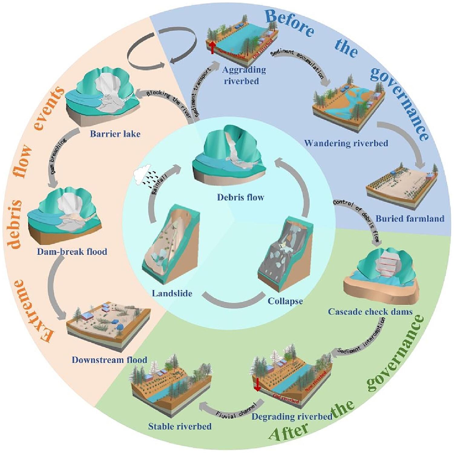
The evolution of riverbeds is greatly impacted by changes in the water–sediment relationship resulting from the movement of debris flows. However, little is known about the influence of management in chronic sediment source areas on the evolution of main-stem riverbed morphology. In this study, we used multi-source remote sensing images covering the past 50 years along with water–sediment and topographic data from a river basin, and sediment transport data from debris flows, to analyze the evolutionary processes of the middle and lower reaches of the Daying River (DYR) at the China-Myanmar border. Our results showed that (1) management of the sediment source area shifted the riverbed morphology from aggradation to erosion, transforming the river surface from wide and shallow to narrow and deep, and the channel from multi-threaded to single-threaded; (2) the active alluvial area, marginal bar area, and average river width exhibited an inverted V-shaped trend, increasing by at least 23% and then decreasing by more than 59%; and (3) the evolution of riverbed morphology contributed to the stability of downstream riverbeds, improved flood control, and enhanced utilization of the floodplains.
期刊介绍:
Earth Surface Processes and Landforms is an interdisciplinary international journal concerned with:
the interactions between surface processes and landforms and landscapes;
that lead to physical, chemical and biological changes; and which in turn create;
current landscapes and the geological record of past landscapes.
Its focus is core to both physical geographical and geological communities, and also the wider geosciences


 分享
分享
 求助内容:
求助内容: 应助结果提醒方式:
 扫码关注我们
