Regional difference and prevention strategy of farmland erosion induced by extreme rainstorms in the Loess area and Rocky mountain area of Northern China
{"title":"Regional difference and prevention strategy of farmland erosion induced by extreme rainstorms in the Loess area and Rocky mountain area of Northern China","authors":"Liang Zhang, Yihang Liu, Yunyun Dong, Yuanhao Liu, Jingqi Jidai, Juying Jiao, Baoyuan Liu, Hao Chen, Jianqiao Han","doi":"10.1002/esp.5851","DOIUrl":null,"url":null,"abstract":"<p>Elucidating the mechanism of soil erosion caused by extreme rainstorms could improve agroecosystems' resilience to the extreme climate. However, less attention has been paid to the regional difference of soil erosion during extreme rainstorms through multiple field investigations. Using six field surveys of extreme rainstorms, soil erosion and its driving mechanism were investigated on farmland in the Loess area and the Rocky mountain area. Conclusions are as follows: (1) Farmland was severely eroded in comparison with abandoned land and forest–grass land. The erosion modulus of farmland in the Loess area (51 606.51 t/km<sup>2</sup>) was greater than that in the Rocky mountain area (2582.75 t/km<sup>2</sup>). (2) In both the Loess area and the Rocky mountain area, the main erosion types on sloped cropland and terraced land were rills/gullies and embankment failure, respectively. Terracing is an appropriate measure that can effectively control farmland erosion in rainstorm events. (3) Concentrated flow is a major driver of soil erosion, with nearly all rills/gullies occurring in the flow paths. Drainage measures can prevent the formation of concentrated flow, weakening rills/gullies erosion in farmland. (4) Building bio-embankment, planting high-coverage crops, and implementing local protection measures could reduce the farmland erosion influenced by extremely heavy rainfall. Combining drainage and agronomic measures is the common strategy to combat extreme rainstorm events for reducing farmland erosion in the two regions. These results can be applied to improve the ability of agricultural systems to cope with extreme rainstorms.</p>","PeriodicalId":11408,"journal":{"name":"Earth Surface Processes and Landforms","volume":"49 9","pages":"2704-2722"},"PeriodicalIF":2.7000,"publicationDate":"2024-05-09","publicationTypes":"Journal Article","fieldsOfStudy":null,"isOpenAccess":false,"openAccessPdf":"","citationCount":"0","resultStr":null,"platform":"Semanticscholar","paperid":null,"PeriodicalName":"Earth Surface Processes and Landforms","FirstCategoryId":"89","ListUrlMain":"https://onlinelibrary.wiley.com/doi/10.1002/esp.5851","RegionNum":3,"RegionCategory":"地球科学","ArticlePicture":[],"TitleCN":null,"AbstractTextCN":null,"PMCID":null,"EPubDate":"","PubModel":"","JCR":"Q2","JCRName":"GEOGRAPHY, PHYSICAL","Score":null,"Total":0}
引用次数: 0
Abstract
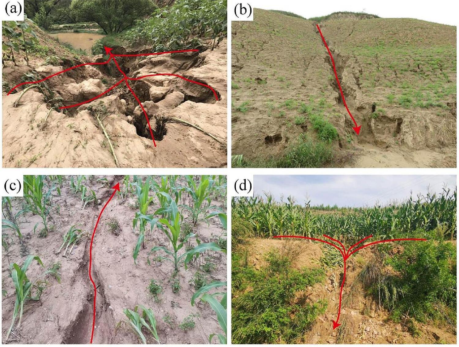
Elucidating the mechanism of soil erosion caused by extreme rainstorms could improve agroecosystems' resilience to the extreme climate. However, less attention has been paid to the regional difference of soil erosion during extreme rainstorms through multiple field investigations. Using six field surveys of extreme rainstorms, soil erosion and its driving mechanism were investigated on farmland in the Loess area and the Rocky mountain area. Conclusions are as follows: (1) Farmland was severely eroded in comparison with abandoned land and forest–grass land. The erosion modulus of farmland in the Loess area (51 606.51 t/km2) was greater than that in the Rocky mountain area (2582.75 t/km2). (2) In both the Loess area and the Rocky mountain area, the main erosion types on sloped cropland and terraced land were rills/gullies and embankment failure, respectively. Terracing is an appropriate measure that can effectively control farmland erosion in rainstorm events. (3) Concentrated flow is a major driver of soil erosion, with nearly all rills/gullies occurring in the flow paths. Drainage measures can prevent the formation of concentrated flow, weakening rills/gullies erosion in farmland. (4) Building bio-embankment, planting high-coverage crops, and implementing local protection measures could reduce the farmland erosion influenced by extremely heavy rainfall. Combining drainage and agronomic measures is the common strategy to combat extreme rainstorm events for reducing farmland erosion in the two regions. These results can be applied to improve the ability of agricultural systems to cope with extreme rainstorms.
期刊介绍:
Earth Surface Processes and Landforms is an interdisciplinary international journal concerned with:
the interactions between surface processes and landforms and landscapes;
that lead to physical, chemical and biological changes; and which in turn create;
current landscapes and the geological record of past landscapes.
Its focus is core to both physical geographical and geological communities, and also the wider geosciences


 分享
分享
 求助内容:
求助内容: 应助结果提醒方式:
 扫码关注我们
