S. Zwieback , J. Young-Robertson , M. Robertson , Y. Tian , Q. Chang , M. Morris , J. White , J. Moan
{"title":"Low-severity spruce beetle infestation mapped from high-resolution satellite imagery with a convolutional network","authors":"S. Zwieback , J. Young-Robertson , M. Robertson , Y. Tian , Q. Chang , M. Morris , J. White , J. Moan","doi":"10.1016/j.isprsjprs.2024.05.013","DOIUrl":null,"url":null,"abstract":"<div><p>Extensive mortality of susceptible spruce can be caused by spruce beetles at epidemic population levels, as in the ongoing outbreak in Southcentral Alaska. Although information on outbreak extent and severity underpins forest management and research, the data products available in Alaska have substantial gaps. Widely available high-resolution satellite imagery are a promising data source for detecting beetle kill because it is possible, though challenging, to identify individual trees. However, the applicability of automated deep-learning approaches for regional-scale mapping has not been evaluated. Here, we assess a deep convolutional network for mapping dead spruce in high-resolution (<span><math><mo>∼</mo></math></span>2<!--> <!-->m) satellite imagery of Southcentral Alaska. The network identified dead spruce pixels across stand characteristics, achieving an average accuracy of 95%. To upscale to the stand scale, we mitigated overestimation of dead tree pixels at elevated severity by calibration. Stand-scale areal severity, the fraction of dead spruce pixels within a stand, was mapped with an RMSE of 0.02 at 90<!--> <!-->m scale. The estimated severity exceeded 0.05 in fewer than 4% of the landscape, and approximately 90% of dead trees pixels were found in low-severity stands. Severity was weakly associated with stand-scale Landsat reflectance changes, a clear relation between SWIR reflectance change and severity only emerging above 0.1 severity. In conclusion, high-resolution satellite imagery are suited to automated mapping of beetle-associated kill at tree and stand scale across the severity spectrum. Such data products support forest and fire management and further understanding of the dynamics and consequences of beetle outbreaks.</p></div>","PeriodicalId":50269,"journal":{"name":"ISPRS Journal of Photogrammetry and Remote Sensing","volume":null,"pages":null},"PeriodicalIF":10.6000,"publicationDate":"2024-05-18","publicationTypes":"Journal Article","fieldsOfStudy":null,"isOpenAccess":false,"openAccessPdf":"https://www.sciencedirect.com/science/article/pii/S0924271624002132/pdfft?md5=958e7d6897a1bea98b955924193751bc&pid=1-s2.0-S0924271624002132-main.pdf","citationCount":"0","resultStr":null,"platform":"Semanticscholar","paperid":null,"PeriodicalName":"ISPRS Journal of Photogrammetry and Remote Sensing","FirstCategoryId":"5","ListUrlMain":"https://www.sciencedirect.com/science/article/pii/S0924271624002132","RegionNum":1,"RegionCategory":"地球科学","ArticlePicture":[],"TitleCN":null,"AbstractTextCN":null,"PMCID":null,"EPubDate":"","PubModel":"","JCR":"Q1","JCRName":"GEOGRAPHY, PHYSICAL","Score":null,"Total":0}
引用次数: 0
Abstract
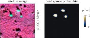
Extensive mortality of susceptible spruce can be caused by spruce beetles at epidemic population levels, as in the ongoing outbreak in Southcentral Alaska. Although information on outbreak extent and severity underpins forest management and research, the data products available in Alaska have substantial gaps. Widely available high-resolution satellite imagery are a promising data source for detecting beetle kill because it is possible, though challenging, to identify individual trees. However, the applicability of automated deep-learning approaches for regional-scale mapping has not been evaluated. Here, we assess a deep convolutional network for mapping dead spruce in high-resolution (2 m) satellite imagery of Southcentral Alaska. The network identified dead spruce pixels across stand characteristics, achieving an average accuracy of 95%. To upscale to the stand scale, we mitigated overestimation of dead tree pixels at elevated severity by calibration. Stand-scale areal severity, the fraction of dead spruce pixels within a stand, was mapped with an RMSE of 0.02 at 90 m scale. The estimated severity exceeded 0.05 in fewer than 4% of the landscape, and approximately 90% of dead trees pixels were found in low-severity stands. Severity was weakly associated with stand-scale Landsat reflectance changes, a clear relation between SWIR reflectance change and severity only emerging above 0.1 severity. In conclusion, high-resolution satellite imagery are suited to automated mapping of beetle-associated kill at tree and stand scale across the severity spectrum. Such data products support forest and fire management and further understanding of the dynamics and consequences of beetle outbreaks.
期刊介绍:
The ISPRS Journal of Photogrammetry and Remote Sensing (P&RS) serves as the official journal of the International Society for Photogrammetry and Remote Sensing (ISPRS). It acts as a platform for scientists and professionals worldwide who are involved in various disciplines that utilize photogrammetry, remote sensing, spatial information systems, computer vision, and related fields. The journal aims to facilitate communication and dissemination of advancements in these disciplines, while also acting as a comprehensive source of reference and archive.
P&RS endeavors to publish high-quality, peer-reviewed research papers that are preferably original and have not been published before. These papers can cover scientific/research, technological development, or application/practical aspects. Additionally, the journal welcomes papers that are based on presentations from ISPRS meetings, as long as they are considered significant contributions to the aforementioned fields.
In particular, P&RS encourages the submission of papers that are of broad scientific interest, showcase innovative applications (especially in emerging fields), have an interdisciplinary focus, discuss topics that have received limited attention in P&RS or related journals, or explore new directions in scientific or professional realms. It is preferred that theoretical papers include practical applications, while papers focusing on systems and applications should include a theoretical background.


 分享
分享
 求助内容:
求助内容: 应助结果提醒方式:
 扫码关注我们
