{"title":"A novel and robust method for large-scale single-season rice mapping based on phenology and statistical data","authors":"Maolin Yang , Bin Guo , Jianlin Wang","doi":"10.1016/j.isprsjprs.2024.05.019","DOIUrl":null,"url":null,"abstract":"<div><p>Accurate and detailed spatial information on rice cultivation is essential to developing agricultural policy and reducing the negative impacts of agriculture. However, the dependence of most traditional methods on samples severely limits the feasibility of large-scale rice cultivation mapping. This study proposes a robust large-scale sample-free monitoring method for single-season rice in northern China. A new rice phenology index, quantifying dynamic phenological features of rice (i.e., the occurrence of flooding during transplanting and the growth of rice after transplanting), was generated to highlight rice. Subsequently, a constrained cyclic threshold classification strategy was designed to obtain plausible rice maps using statistical data. Innovatively combining rice mapping with statistical data, the most detailed (10 m) single-season rice map in northern China to date was created. Compared with three other high-precision rice map products, the resulting rice map has high accuracy and good local details. The results indicate that the rice phenology index has excellent and robust performance in identifying rice cultivation locations in northern China. Moreover, the proposed mapping method exhibits clear advantages in the tracking of large-scale and historical rice cultivation. As a whole, this study provides a paradigm of using statistical data instead of samples for crop mapping.</p></div>","PeriodicalId":50269,"journal":{"name":"ISPRS Journal of Photogrammetry and Remote Sensing","volume":"213 ","pages":"Pages 14-32"},"PeriodicalIF":12.2000,"publicationDate":"2024-07-01","publicationTypes":"Journal Article","fieldsOfStudy":null,"isOpenAccess":false,"openAccessPdf":"","citationCount":"0","resultStr":null,"platform":"Semanticscholar","paperid":null,"PeriodicalName":"ISPRS Journal of Photogrammetry and Remote Sensing","FirstCategoryId":"5","ListUrlMain":"https://www.sciencedirect.com/science/article/pii/S092427162400217X","RegionNum":1,"RegionCategory":"地球科学","ArticlePicture":[],"TitleCN":null,"AbstractTextCN":null,"PMCID":null,"EPubDate":"2024/5/25 0:00:00","PubModel":"Epub","JCR":"Q1","JCRName":"GEOGRAPHY, PHYSICAL","Score":null,"Total":0}
引用次数: 0
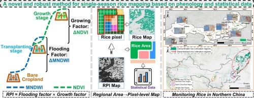
Abstract
Accurate and detailed spatial information on rice cultivation is essential to developing agricultural policy and reducing the negative impacts of agriculture. However, the dependence of most traditional methods on samples severely limits the feasibility of large-scale rice cultivation mapping. This study proposes a robust large-scale sample-free monitoring method for single-season rice in northern China. A new rice phenology index, quantifying dynamic phenological features of rice (i.e., the occurrence of flooding during transplanting and the growth of rice after transplanting), was generated to highlight rice. Subsequently, a constrained cyclic threshold classification strategy was designed to obtain plausible rice maps using statistical data. Innovatively combining rice mapping with statistical data, the most detailed (10 m) single-season rice map in northern China to date was created. Compared with three other high-precision rice map products, the resulting rice map has high accuracy and good local details. The results indicate that the rice phenology index has excellent and robust performance in identifying rice cultivation locations in northern China. Moreover, the proposed mapping method exhibits clear advantages in the tracking of large-scale and historical rice cultivation. As a whole, this study provides a paradigm of using statistical data instead of samples for crop mapping.
期刊介绍:
The ISPRS Journal of Photogrammetry and Remote Sensing (P&RS) serves as the official journal of the International Society for Photogrammetry and Remote Sensing (ISPRS). It acts as a platform for scientists and professionals worldwide who are involved in various disciplines that utilize photogrammetry, remote sensing, spatial information systems, computer vision, and related fields. The journal aims to facilitate communication and dissemination of advancements in these disciplines, while also acting as a comprehensive source of reference and archive.
P&RS endeavors to publish high-quality, peer-reviewed research papers that are preferably original and have not been published before. These papers can cover scientific/research, technological development, or application/practical aspects. Additionally, the journal welcomes papers that are based on presentations from ISPRS meetings, as long as they are considered significant contributions to the aforementioned fields.
In particular, P&RS encourages the submission of papers that are of broad scientific interest, showcase innovative applications (especially in emerging fields), have an interdisciplinary focus, discuss topics that have received limited attention in P&RS or related journals, or explore new directions in scientific or professional realms. It is preferred that theoretical papers include practical applications, while papers focusing on systems and applications should include a theoretical background.


 分享
分享
 求助内容:
求助内容: 应助结果提醒方式:
 扫码关注我们
