{"title":"Effects of fragmentation characters on wetland hydrological changes in Rarh region, West Bengal, India","authors":"Rumki Khatun, Somen Das","doi":"10.1007/s11600-024-01350-2","DOIUrl":null,"url":null,"abstract":"<div><p>The current study aims to quantify the relationship between hydrological richness in river and riparian wetland habitats and fragmentation analysis. Eight relevant parameters, such as the frequency of water presence, hydro-period, and proximity to the river, have been incorporated into four models—two statistical models (Shannon entropy and Logistic Regression) and two machine learning models (artificial neural network and random forest)—in order to investigate wetland hydrological richness. The models are evaluated using statistical techniques such as ROC curves, and field-based validation is also performed. The information about the best-performing models (random forest for machine learning and logistic regression for statistical models) is valuable for understanding the predictive capabilities of the models applied. RF model identified 168.43 km<sup>2</sup>, 110.91 km<sup>2</sup>, 70.13 km<sup>2</sup>, and 39.15 km<sup>2</sup> areas as having very rich and rich water richness zones in 1990, 2000, 2010, and 2020, respectively. The percentage of poor and very poor areas has rapidly increased from 29.7% in 1990 to 55.35% in 2020. Additionally, the relationship between wetland fragmentation and hydrological richness is assessed. Wetland fragmentation and shrinking core areas due to anthropogenic intrusion significantly impact the hydrological richness of wetlands. This study will provide important insights into the changing state of wetlands over time, especially concerning the impact of anthropogenic activities on hydrological richness. The findings of this study would have significant implications for wetland management and precautions on manmade hydrological modification.</p><h3>Graphical abstract</h3><div><figure><div><div><picture><source><img></source></picture></div></div></figure></div></div>","PeriodicalId":6988,"journal":{"name":"Acta Geophysica","volume":"73 1","pages":"661 - 685"},"PeriodicalIF":2.1000,"publicationDate":"2024-05-24","publicationTypes":"Journal Article","fieldsOfStudy":null,"isOpenAccess":false,"openAccessPdf":"","citationCount":"0","resultStr":null,"platform":"Semanticscholar","paperid":null,"PeriodicalName":"Acta Geophysica","FirstCategoryId":"89","ListUrlMain":"https://link.springer.com/article/10.1007/s11600-024-01350-2","RegionNum":4,"RegionCategory":"地球科学","ArticlePicture":[],"TitleCN":null,"AbstractTextCN":null,"PMCID":null,"EPubDate":"","PubModel":"","JCR":"","JCRName":"","Score":null,"Total":0}
引用次数: 0
Abstract
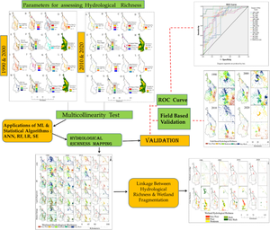
The current study aims to quantify the relationship between hydrological richness in river and riparian wetland habitats and fragmentation analysis. Eight relevant parameters, such as the frequency of water presence, hydro-period, and proximity to the river, have been incorporated into four models—two statistical models (Shannon entropy and Logistic Regression) and two machine learning models (artificial neural network and random forest)—in order to investigate wetland hydrological richness. The models are evaluated using statistical techniques such as ROC curves, and field-based validation is also performed. The information about the best-performing models (random forest for machine learning and logistic regression for statistical models) is valuable for understanding the predictive capabilities of the models applied. RF model identified 168.43 km2, 110.91 km2, 70.13 km2, and 39.15 km2 areas as having very rich and rich water richness zones in 1990, 2000, 2010, and 2020, respectively. The percentage of poor and very poor areas has rapidly increased from 29.7% in 1990 to 55.35% in 2020. Additionally, the relationship between wetland fragmentation and hydrological richness is assessed. Wetland fragmentation and shrinking core areas due to anthropogenic intrusion significantly impact the hydrological richness of wetlands. This study will provide important insights into the changing state of wetlands over time, especially concerning the impact of anthropogenic activities on hydrological richness. The findings of this study would have significant implications for wetland management and precautions on manmade hydrological modification.
期刊介绍:
Acta Geophysica is open to all kinds of manuscripts including research and review articles, short communications, comments to published papers, letters to the Editor as well as book reviews. Some of the issues are fully devoted to particular topics; we do encourage proposals for such topical issues. We accept submissions from scientists world-wide, offering high scientific and editorial standard and comprehensive treatment of the discussed topics.


 分享
分享
 求助内容:
求助内容: 应助结果提醒方式:
 扫码关注我们
