Thomas B. Doyle, Patrick A. Hesp, Colin D. Woodroffe
{"title":"Foredune morphology: Regional patterns and surfzone–beach–dune interactions along the New South Wales coast, Australia","authors":"Thomas B. Doyle, Patrick A. Hesp, Colin D. Woodroffe","doi":"10.1002/esp.5879","DOIUrl":null,"url":null,"abstract":"<p>Foredunes constitute a fundamental part of the coastal environment, acting as a buffer against storm erosion and natural coastal defence. Foredune size and volume play a pivotal role in determining coastal vulnerability to marine hazards, and the governing processes driving variations in foredune morphology, particularly over regional, or larger spatial scales, are still relatively poorly understood. This paper presents a regional-scale investigation into foredune morphology along the New South Wales (NSW) coast (SE Australia), comprising not only a state-wide inventory of foredune morphology for use in management/hazard assessment, but also testing long-standing hypotheses and conceptual models of the physical processes that are driving, or influencing, foredune size. We applied a remote sensing protocol to 47 foredune environments, covering the length of the NSW coastline, comparing morphology (including dune height, width, shape, and volume) of established and incipient foredunes both along, and between, sandy embayments. Results, at regional spatial scales, show that the largest foredunes (volumes up to 850 m<sup>3</sup> m<sup>−1</sup>) occur along the central coast as large, steep landforms; intermediate-sized dunes (550–650 m<sup>3</sup> m<sup>−1</sup>) were found on both the Mid-north and Far North coast, and the smallest foredunes (334–380 m<sup>3</sup> m<sup>−1</sup>) occur on the south coast as wider dunes with steep stoss slopes. Surfzone–beach state was found to be the most significant factor influencing foredune size and volume. The more energetic and more dissipative/high-energy intermediate surfzone–beach states were correlated with larger foredunes (i.e. greater dune volume, width and crest elevation), whereas the lower-energy surfzone–beach states generally had smaller dunes. Changes in vegetation cover, shoreline orientation and associated onshore (and alongshore) wind systems were also demonstrated to be important factors in determining foredune morphology. The largest foredunes in NSW generally occur to the north of embayments, with dune size decreasing southward with decreasing exposure to wind/wave energy.</p>","PeriodicalId":11408,"journal":{"name":"Earth Surface Processes and Landforms","volume":"49 10","pages":"3115-3138"},"PeriodicalIF":2.7000,"publicationDate":"2024-05-25","publicationTypes":"Journal Article","fieldsOfStudy":null,"isOpenAccess":false,"openAccessPdf":"https://onlinelibrary.wiley.com/doi/epdf/10.1002/esp.5879","citationCount":"0","resultStr":null,"platform":"Semanticscholar","paperid":null,"PeriodicalName":"Earth Surface Processes and Landforms","FirstCategoryId":"89","ListUrlMain":"https://onlinelibrary.wiley.com/doi/10.1002/esp.5879","RegionNum":3,"RegionCategory":"地球科学","ArticlePicture":[],"TitleCN":null,"AbstractTextCN":null,"PMCID":null,"EPubDate":"","PubModel":"","JCR":"Q2","JCRName":"GEOGRAPHY, PHYSICAL","Score":null,"Total":0}
引用次数: 0
Abstract
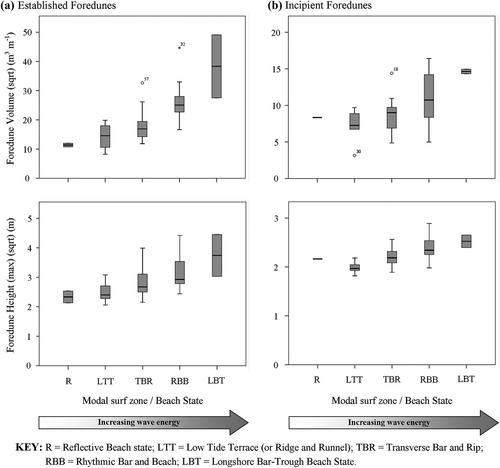
Foredunes constitute a fundamental part of the coastal environment, acting as a buffer against storm erosion and natural coastal defence. Foredune size and volume play a pivotal role in determining coastal vulnerability to marine hazards, and the governing processes driving variations in foredune morphology, particularly over regional, or larger spatial scales, are still relatively poorly understood. This paper presents a regional-scale investigation into foredune morphology along the New South Wales (NSW) coast (SE Australia), comprising not only a state-wide inventory of foredune morphology for use in management/hazard assessment, but also testing long-standing hypotheses and conceptual models of the physical processes that are driving, or influencing, foredune size. We applied a remote sensing protocol to 47 foredune environments, covering the length of the NSW coastline, comparing morphology (including dune height, width, shape, and volume) of established and incipient foredunes both along, and between, sandy embayments. Results, at regional spatial scales, show that the largest foredunes (volumes up to 850 m3 m−1) occur along the central coast as large, steep landforms; intermediate-sized dunes (550–650 m3 m−1) were found on both the Mid-north and Far North coast, and the smallest foredunes (334–380 m3 m−1) occur on the south coast as wider dunes with steep stoss slopes. Surfzone–beach state was found to be the most significant factor influencing foredune size and volume. The more energetic and more dissipative/high-energy intermediate surfzone–beach states were correlated with larger foredunes (i.e. greater dune volume, width and crest elevation), whereas the lower-energy surfzone–beach states generally had smaller dunes. Changes in vegetation cover, shoreline orientation and associated onshore (and alongshore) wind systems were also demonstrated to be important factors in determining foredune morphology. The largest foredunes in NSW generally occur to the north of embayments, with dune size decreasing southward with decreasing exposure to wind/wave energy.
期刊介绍:
Earth Surface Processes and Landforms is an interdisciplinary international journal concerned with:
the interactions between surface processes and landforms and landscapes;
that lead to physical, chemical and biological changes; and which in turn create;
current landscapes and the geological record of past landscapes.
Its focus is core to both physical geographical and geological communities, and also the wider geosciences


 分享
分享
 求助内容:
求助内容: 应助结果提醒方式:
 扫码关注我们
