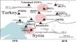
{"title":"Investigation of the displacements of CORS-TR stations before (05.02.2023) and after the Maraş-Hatay earthquakes (01.03.2023) in Turkey","authors":"Atınç Pırtı","doi":"10.1007/s12517-024-12006-2","DOIUrl":null,"url":null,"abstract":"<p>Understanding the Earth’s deformation before and after the earthquake occurrences is very crucial to monitor the deformation, probability of the future risks, prevent people’s lives, and keep the safety of any civil engineering structures or loss of billion dollars. Therefore, this research work is appreciable and good to monitor and give awareness for the concerned body to prevent any civil engineering structures/infrastructure damage and death of a life in seismic hazard-prone regions. Southern Turkey faced widespread catastrophic destruction by two devastating earthquakes on the same day. As the earthquakes occurred at 04:17 (<i>M</i><sub><i>w</i></sub> = 7.7, Pazarcık, Maraş) and 12:30 (<i>M</i><sub><i>w</i></sub> = 7.6, Elbistan, Maraş) on 6 February 2023, neighbouring active fault systems were broken in succession between the Hatay and Malatya provinces in the region. On 6 February 2023, Mw 7.8 and Mw 7.5 earthquakes occurred in the transition between the Dead Sea fault and the East Anatolian fault. The southern Turkish city of Hatay had a 6.3 magnitude earthquake at 20:04 on February 20, 2023. Three minutes later, a 5.8 magnitude aftershock occurred, and 90 more aftershocks followed. In this study the obtained coordinate displacements of CORS-TR stations after three earthquakes were computed by using static GNSS method. The aim of this study shows the horizontal and vertical coordinate discrepancies of CORS-TR stations after the three earthquakes (by using static method (05.02.2023–01.03.2023)), which range from a few centimetres to about 467.40 cm (EZK1 has the largest horizontal movement with values about 467.40 as compared to the other stations). The estimated largest displacements caused by the Mw 7.8 event are observed at station EKZ1 which is only 6 km from the epicentre of the event.</p>","PeriodicalId":476,"journal":{"name":"Arabian Journal of Geosciences","volume":null,"pages":null},"PeriodicalIF":1.8270,"publicationDate":"2024-05-28","publicationTypes":"Journal Article","fieldsOfStudy":null,"isOpenAccess":false,"openAccessPdf":"","citationCount":"0","resultStr":null,"platform":"Semanticscholar","paperid":null,"PeriodicalName":"Arabian Journal of Geosciences","FirstCategoryId":"1085","ListUrlMain":"https://doi.org/10.1007/s12517-024-12006-2","RegionNum":0,"RegionCategory":null,"ArticlePicture":[],"TitleCN":null,"AbstractTextCN":null,"PMCID":null,"EPubDate":"","PubModel":"","JCR":"Q2","JCRName":"Earth and Planetary Sciences","Score":null,"Total":0}
引用次数: 0
Abstract
Understanding the Earth’s deformation before and after the earthquake occurrences is very crucial to monitor the deformation, probability of the future risks, prevent people’s lives, and keep the safety of any civil engineering structures or loss of billion dollars. Therefore, this research work is appreciable and good to monitor and give awareness for the concerned body to prevent any civil engineering structures/infrastructure damage and death of a life in seismic hazard-prone regions. Southern Turkey faced widespread catastrophic destruction by two devastating earthquakes on the same day. As the earthquakes occurred at 04:17 (Mw = 7.7, Pazarcık, Maraş) and 12:30 (Mw = 7.6, Elbistan, Maraş) on 6 February 2023, neighbouring active fault systems were broken in succession between the Hatay and Malatya provinces in the region. On 6 February 2023, Mw 7.8 and Mw 7.5 earthquakes occurred in the transition between the Dead Sea fault and the East Anatolian fault. The southern Turkish city of Hatay had a 6.3 magnitude earthquake at 20:04 on February 20, 2023. Three minutes later, a 5.8 magnitude aftershock occurred, and 90 more aftershocks followed. In this study the obtained coordinate displacements of CORS-TR stations after three earthquakes were computed by using static GNSS method. The aim of this study shows the horizontal and vertical coordinate discrepancies of CORS-TR stations after the three earthquakes (by using static method (05.02.2023–01.03.2023)), which range from a few centimetres to about 467.40 cm (EZK1 has the largest horizontal movement with values about 467.40 as compared to the other stations). The estimated largest displacements caused by the Mw 7.8 event are observed at station EKZ1 which is only 6 km from the epicentre of the event.
期刊介绍:
The Arabian Journal of Geosciences is the official journal of the Saudi Society for Geosciences and publishes peer-reviewed original and review articles on the entire range of Earth Science themes, focused on, but not limited to, those that have regional significance to the Middle East and the Euro-Mediterranean Zone.
Key topics therefore include; geology, hydrogeology, earth system science, petroleum sciences, geophysics, seismology and crustal structures, tectonics, sedimentology, palaeontology, metamorphic and igneous petrology, natural hazards, environmental sciences and sustainable development, geoarchaeology, geomorphology, paleo-environment studies, oceanography, atmospheric sciences, GIS and remote sensing, geodesy, mineralogy, volcanology, geochemistry and metallogenesis.


 分享
分享
 求助内容:
求助内容: 应助结果提醒方式:
 扫码关注我们
