Modelling, quantification and estimation of the soil water erosion using the Revised Universal Soil Loss Equation with Sediment Delivery Ratio and the analytic hierarchy process models
Belhaj Fatima, Hlila Rachid, El Kadiri Khalil, Ouallali Abdessalam, Belkendil Abdeldjalil, Beroho Mohamed, Aqil Tariq, J. Davis Brian, Walid Soufan
{"title":"Modelling, quantification and estimation of the soil water erosion using the Revised Universal Soil Loss Equation with Sediment Delivery Ratio and the analytic hierarchy process models","authors":"Belhaj Fatima, Hlila Rachid, El Kadiri Khalil, Ouallali Abdessalam, Belkendil Abdeldjalil, Beroho Mohamed, Aqil Tariq, J. Davis Brian, Walid Soufan","doi":"10.1002/esp.5882","DOIUrl":null,"url":null,"abstract":"<p>This research used the Revised Universal Soil Loss Equation (RUSLE) with Sediment Delivery Ratio (SDR) model. The analytic hierarchy process (AHP) method, while also incorporating the use of a geographic information system (GIS) and remote sensing (RS) to predict the annual soil loss rate and spatialise the processes of water erosion at the scale of the Loukkos Watershed, Morocco. The RUSLE model and AHP parameters were estimated using RS data, and the erosion vulnerability zones were determined using GIS. We used five parameters, including precipitation erosivity, soil erodibility, slope length and steepness, vegetation cover, and soil erosion control practices in the RUSLE. For the AHP technique, we used seven geo-environmental factors, including annual average precipitation, drainage density, lineament density, slope, soil texture, land use/land cover and landform maps. The results of RUSLE indicated that the average annual soil loss varied from 0 to 2388.27 \n<span></span><math>\n <mi>t</mi>\n <mo>·</mo>\n <msup>\n <mi>ha</mi>\n <mrow>\n <mo>−</mo>\n <mn>1</mn>\n </mrow>\n </msup>\n <mo>·</mo>\n <msup>\n <mtext>year</mtext>\n <mrow>\n <mo>−</mo>\n <mn>1</mn>\n </mrow>\n </msup></math>. The total estimated annual potential soil loss was approximately 40 790 220.11 \n<span></span><math>\n <mspace></mspace>\n <mi>t</mi>\n <mo>·</mo>\n <msup>\n <mi>ha</mi>\n <mrow>\n <mo>−</mo>\n <mn>1</mn>\n </mrow>\n </msup>\n <mo>·</mo>\n <msup>\n <mtext>year</mtext>\n <mrow>\n <mo>−</mo>\n <mn>1</mn>\n </mrow>\n </msup></math>, and a sediment yield estimated by RUSLE-SDR was 8 647 526.66 \n<span></span><math>\n <mi>t</mi>\n <mo>·</mo>\n <msup>\n <mi>ha</mi>\n <mrow>\n <mo>−</mo>\n <mn>1</mn>\n </mrow>\n </msup>\n <mo>·</mo>\n <msup>\n <mtext>year</mtext>\n <mrow>\n <mo>−</mo>\n <mn>1</mn>\n </mrow>\n </msup></math>, equivalent to 6.65 Mm<sup>3</sup>. This value is very close to the measured value of 6.81 Mm<sup>3</sup>, for a difference of 0.16 Mm<sup>3</sup>. Furthermore, the results of the AHP indicate that the soil erosion potential index varies from 0 to 0.205315 \n<span></span><math>\n <mi>t</mi>\n <mo>·</mo>\n <msup>\n <mi>ha</mi>\n <mrow>\n <mo>−</mo>\n <mn>1</mn>\n </mrow>\n </msup>\n <mo>·</mo>\n <msup>\n <mtext>year</mtext>\n <mrow>\n <mo>−</mo>\n <mn>1</mn>\n </mrow>\n </msup></math>. Overall, nearly 13.7% of the area suffered from severe soil erosion exceeding 50 \n<span></span><math>\n <mi>t</mi>\n <mo>·</mo>\n <msup>\n <mi>ha</mi>\n <mrow>\n <mo>−</mo>\n <mn>1</mn>\n </mrow>\n </msup>\n <mo>·</mo>\n <msup>\n <mtext>year</mtext>\n <mrow>\n <mo>−</mo>\n <mn>1</mn>\n </mrow>\n </msup></math>. Approximately 80% of the Loukkos Watershed area experienced only slight erosion, while the remaining 6% incurred moderate erosion. Integrating GIS and RS into the RUSLE model and AHP helped us robustly estimate the extent and degree of erosion risk. Territorial decision-makers should adopt our results to develop soil conservation strategies, water management plans and other necessary soil and water conservation measures for this region.</p>","PeriodicalId":11408,"journal":{"name":"Earth Surface Processes and Landforms","volume":"49 10","pages":"3158-3176"},"PeriodicalIF":2.7000,"publicationDate":"2024-05-26","publicationTypes":"Journal Article","fieldsOfStudy":null,"isOpenAccess":false,"openAccessPdf":"","citationCount":"0","resultStr":null,"platform":"Semanticscholar","paperid":null,"PeriodicalName":"Earth Surface Processes and Landforms","FirstCategoryId":"89","ListUrlMain":"https://onlinelibrary.wiley.com/doi/10.1002/esp.5882","RegionNum":3,"RegionCategory":"地球科学","ArticlePicture":[],"TitleCN":null,"AbstractTextCN":null,"PMCID":null,"EPubDate":"","PubModel":"","JCR":"Q2","JCRName":"GEOGRAPHY, PHYSICAL","Score":null,"Total":0}
引用次数: 0
Abstract
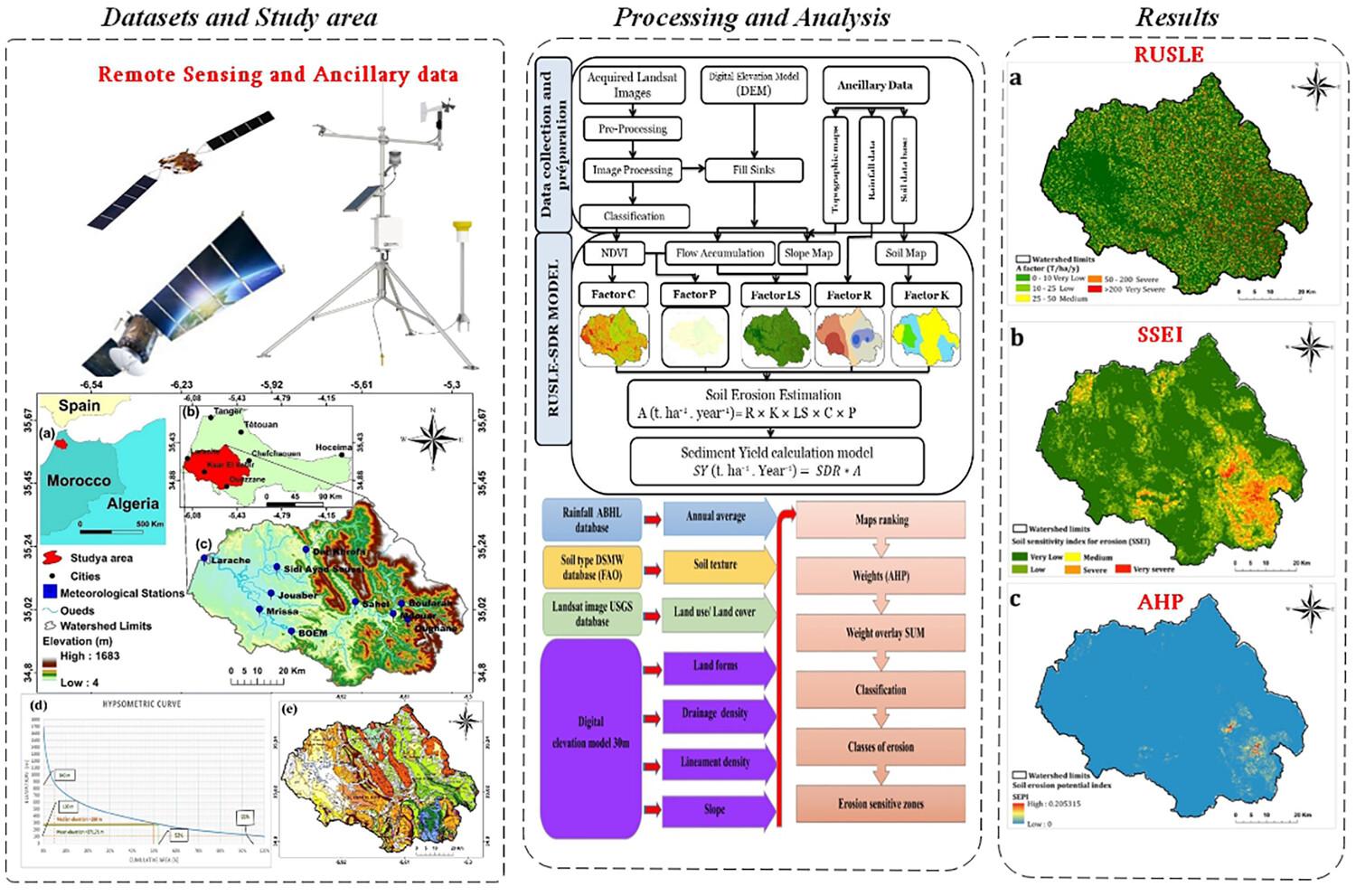
This research used the Revised Universal Soil Loss Equation (RUSLE) with Sediment Delivery Ratio (SDR) model. The analytic hierarchy process (AHP) method, while also incorporating the use of a geographic information system (GIS) and remote sensing (RS) to predict the annual soil loss rate and spatialise the processes of water erosion at the scale of the Loukkos Watershed, Morocco. The RUSLE model and AHP parameters were estimated using RS data, and the erosion vulnerability zones were determined using GIS. We used five parameters, including precipitation erosivity, soil erodibility, slope length and steepness, vegetation cover, and soil erosion control practices in the RUSLE. For the AHP technique, we used seven geo-environmental factors, including annual average precipitation, drainage density, lineament density, slope, soil texture, land use/land cover and landform maps. The results of RUSLE indicated that the average annual soil loss varied from 0 to 2388.27
. The total estimated annual potential soil loss was approximately 40 790 220.11
, and a sediment yield estimated by RUSLE-SDR was 8 647 526.66
, equivalent to 6.65 Mm3. This value is very close to the measured value of 6.81 Mm3, for a difference of 0.16 Mm3. Furthermore, the results of the AHP indicate that the soil erosion potential index varies from 0 to 0.205315
. Overall, nearly 13.7% of the area suffered from severe soil erosion exceeding 50
. Approximately 80% of the Loukkos Watershed area experienced only slight erosion, while the remaining 6% incurred moderate erosion. Integrating GIS and RS into the RUSLE model and AHP helped us robustly estimate the extent and degree of erosion risk. Territorial decision-makers should adopt our results to develop soil conservation strategies, water management plans and other necessary soil and water conservation measures for this region.
期刊介绍:
Earth Surface Processes and Landforms is an interdisciplinary international journal concerned with:
the interactions between surface processes and landforms and landscapes;
that lead to physical, chemical and biological changes; and which in turn create;
current landscapes and the geological record of past landscapes.
Its focus is core to both physical geographical and geological communities, and also the wider geosciences


 分享
分享
 求助内容:
求助内容: 应助结果提醒方式:
 扫码关注我们
