Yijia Ye, Xibin Tan, Chao Zhou, Shuang Bian, Yiduo Liu, Feng Shi
{"title":"Cross-divide difference in channel-head steady-state elevation controls drainage-divide migration","authors":"Yijia Ye, Xibin Tan, Chao Zhou, Shuang Bian, Yiduo Liu, Feng Shi","doi":"10.1002/esp.5892","DOIUrl":null,"url":null,"abstract":"<p>It is generally agreed that the channel-head steady-state elevations (\n<span></span><math>\n <msub>\n <mi>z</mi>\n <mi>s</mi>\n </msub></math>) across a drainage divide are different when the drainage divide is moving. However, whether it is the hillslope or river channel that absorbs the cross-divide difference in channel-head steady-state elevation (\n<span></span><math>\n <mi>Δ</mi>\n <msub>\n <mi>z</mi>\n <mi>s</mi>\n </msub></math>) remains unclear. These different views have consequences for both the methods used to measure drainage-divide stability and tectonic reconstructions from channel profiles. Two methods for determining drainage-divide stability include Gilbert metrics and <i>χ</i>-plots, which emphasise the role of hillslopes and river channels, respectively. Here, we address this issue by deducing equations for estimating \n<span></span><math>\n <mi>Δ</mi>\n <msub>\n <mi>z</mi>\n <mi>s</mi>\n </msub></math> and identifying the absorbers of \n<span></span><math>\n <mi>Δ</mi>\n <msub>\n <mi>z</mi>\n <mi>s</mi>\n </msub></math> using numerical simulations and two natural cases. Our results show that both hillslopes and river channels absorb parts of \n<span></span><math>\n <mi>Δ</mi>\n <msub>\n <mi>z</mi>\n <mi>s</mi>\n </msub></math> in each case; however, the proportion absorbed varies from case to case. When the hillslope absorbs a greater proportion of \n<span></span><math>\n <mi>Δ</mi>\n <msub>\n <mi>z</mi>\n <mi>s</mi>\n </msub></math>, the river channel absorbs less, and vice versa. We suggest that both Gilbert metrics and <i>χ</i>-plots should be applied when evaluating drainage-divide stability; if either suggests the divide is unstable, then it is indeed unstable. Moreover, the river channel profiles on both sides of a drainage divide are in disequilibrium when the divide is moving, and the erosion rates are greater and less than the uplift rates at the expanding and shrinking sides, respectively. This underscores that drainage-divide migration can significantly hinder the extraction of uplift history from channel profiles.</p>","PeriodicalId":11408,"journal":{"name":"Earth Surface Processes and Landforms","volume":"49 11","pages":"3332-3343"},"PeriodicalIF":2.8000,"publicationDate":"2024-06-03","publicationTypes":"Journal Article","fieldsOfStudy":null,"isOpenAccess":false,"openAccessPdf":"","citationCount":"0","resultStr":null,"platform":"Semanticscholar","paperid":null,"PeriodicalName":"Earth Surface Processes and Landforms","FirstCategoryId":"89","ListUrlMain":"https://onlinelibrary.wiley.com/doi/10.1002/esp.5892","RegionNum":3,"RegionCategory":"地球科学","ArticlePicture":[],"TitleCN":null,"AbstractTextCN":null,"PMCID":null,"EPubDate":"","PubModel":"","JCR":"Q2","JCRName":"GEOGRAPHY, PHYSICAL","Score":null,"Total":0}
引用次数: 0
Abstract
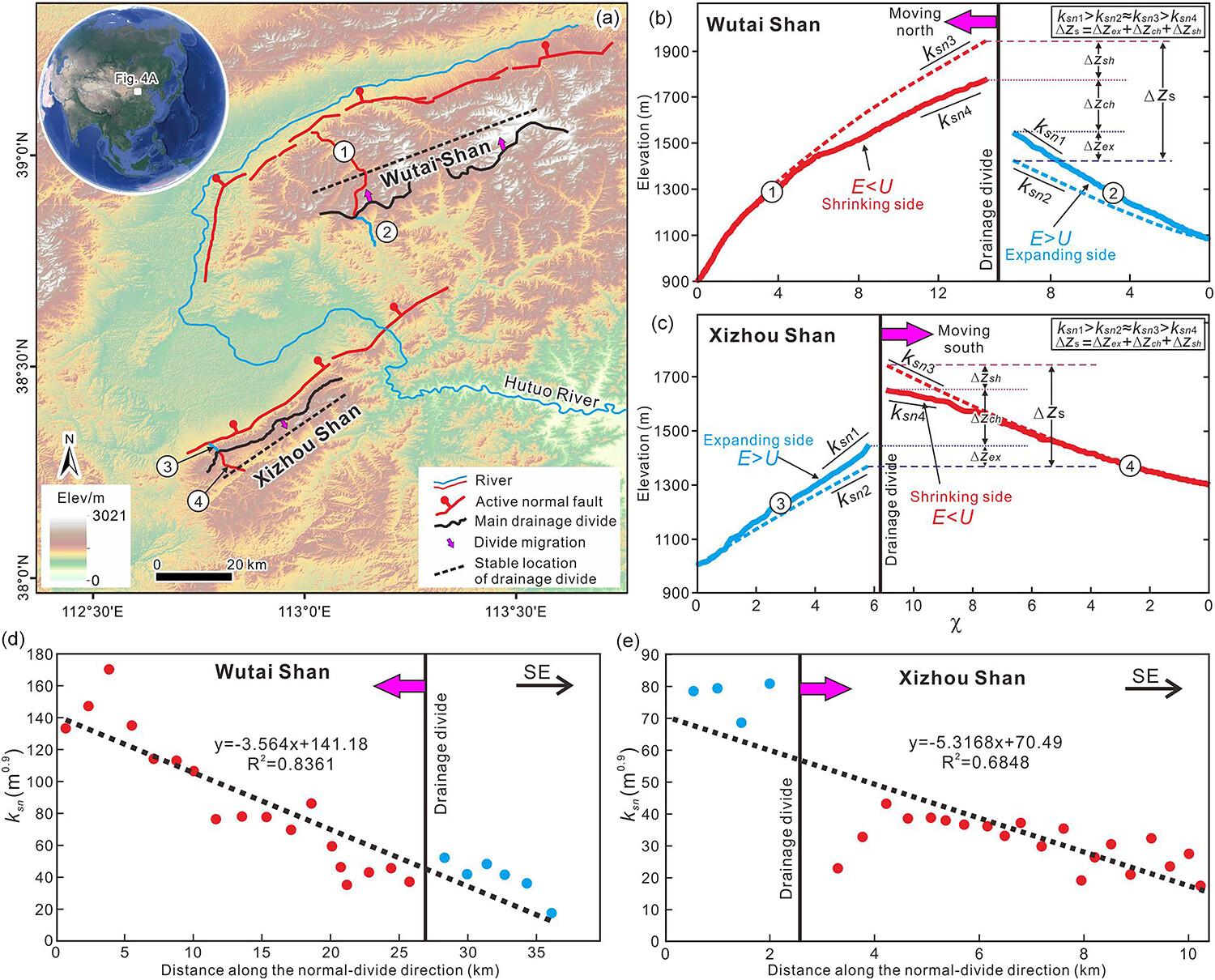
It is generally agreed that the channel-head steady-state elevations (
) across a drainage divide are different when the drainage divide is moving. However, whether it is the hillslope or river channel that absorbs the cross-divide difference in channel-head steady-state elevation (
) remains unclear. These different views have consequences for both the methods used to measure drainage-divide stability and tectonic reconstructions from channel profiles. Two methods for determining drainage-divide stability include Gilbert metrics and χ-plots, which emphasise the role of hillslopes and river channels, respectively. Here, we address this issue by deducing equations for estimating
and identifying the absorbers of
using numerical simulations and two natural cases. Our results show that both hillslopes and river channels absorb parts of
in each case; however, the proportion absorbed varies from case to case. When the hillslope absorbs a greater proportion of
, the river channel absorbs less, and vice versa. We suggest that both Gilbert metrics and χ-plots should be applied when evaluating drainage-divide stability; if either suggests the divide is unstable, then it is indeed unstable. Moreover, the river channel profiles on both sides of a drainage divide are in disequilibrium when the divide is moving, and the erosion rates are greater and less than the uplift rates at the expanding and shrinking sides, respectively. This underscores that drainage-divide migration can significantly hinder the extraction of uplift history from channel profiles.
期刊介绍:
Earth Surface Processes and Landforms is an interdisciplinary international journal concerned with:
the interactions between surface processes and landforms and landscapes;
that lead to physical, chemical and biological changes; and which in turn create;
current landscapes and the geological record of past landscapes.
Its focus is core to both physical geographical and geological communities, and also the wider geosciences


 分享
分享
 求助内容:
求助内容: 应助结果提醒方式:
 扫码关注我们
