Asid Ur Rehman , Vassilis Glenis , Elizabeth Lewis , Chris Kilsby
{"title":"Multi-objective optimisation framework for Blue-Green Infrastructure placement using detailed flood model","authors":"Asid Ur Rehman , Vassilis Glenis , Elizabeth Lewis , Chris Kilsby","doi":"10.1016/j.jhydrol.2024.131571","DOIUrl":null,"url":null,"abstract":"<div><p>Designing city-scale Blue-Green Infrastructure (BGI) for flood risk management requires detailed and robust methods. This is due to the complex interaction of flow pathways and the need to assess cost-benefit trade-offs for various BGI options. This study aims to find a cost-effective BGI placement scheme by developing an improved approach called the Cost OptimisatioN Framework for Implementing blue-Green infrastructURE (CONFIGURE). The optimisation framework integrates a detailed hydrodynamic flood simulation model with a multi-objective optimisation algorithm (Non-dominated Sorting Genetic Algorithm II). The use of a high-resolution flood simulation model ensures the explicit representation of BGI and other land use features to simulate flow pathways and surface flood risk accurately, while the optimisation algorithm guarantees achieving the best cost-benefit trade-offs for given BGI options. The current study uses the advanced CityCAT hydrodynamic flood model to evaluate the efficiency of the optimisation framework and the impact of location and size of permeable interventions on the optimisation process and subsequent cost-benefit trade-offs. This is achieved by dividing permeable surface areas into intervention zones of varying size and quantity. Furthermore, rainstorm events with 100-year and 30-year return periods are analysed to identify any common optimal solutions for different rainfall intensities. Depending on the number of intervention locations, the automated framework reliably achieves optimal BGI implementation solutions in a fraction of the time required to find the best solutions by trialling all possible options. Designing and optimising interventions with smaller sizes but many permeable zones save a good fraction of investment. However, such a design scheme requires more computational time to find optimal options. Furthermore, the optimal spatial configuration of BGI varies with different rainstorm severities, suggesting a need for careful selection of the rainstorm return period. Based on the results, CONFIGURE shows promise in devising sustainable urban flood risk management designs.</p></div>","PeriodicalId":362,"journal":{"name":"Journal of Hydrology","volume":"638 ","pages":"Article 131571"},"PeriodicalIF":6.3000,"publicationDate":"2024-07-01","publicationTypes":"Journal Article","fieldsOfStudy":null,"isOpenAccess":false,"openAccessPdf":"https://www.sciencedirect.com/science/article/pii/S0022169424009673/pdfft?md5=bad3200fcd55aaf2e1571598958fb66f&pid=1-s2.0-S0022169424009673-main.pdf","citationCount":"0","resultStr":null,"platform":"Semanticscholar","paperid":null,"PeriodicalName":"Journal of Hydrology","FirstCategoryId":"89","ListUrlMain":"https://www.sciencedirect.com/science/article/pii/S0022169424009673","RegionNum":1,"RegionCategory":"地球科学","ArticlePicture":[],"TitleCN":null,"AbstractTextCN":null,"PMCID":null,"EPubDate":"2024/6/22 0:00:00","PubModel":"Epub","JCR":"Q1","JCRName":"ENGINEERING, CIVIL","Score":null,"Total":0}
引用次数: 0
Abstract
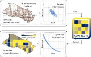
Designing city-scale Blue-Green Infrastructure (BGI) for flood risk management requires detailed and robust methods. This is due to the complex interaction of flow pathways and the need to assess cost-benefit trade-offs for various BGI options. This study aims to find a cost-effective BGI placement scheme by developing an improved approach called the Cost OptimisatioN Framework for Implementing blue-Green infrastructURE (CONFIGURE). The optimisation framework integrates a detailed hydrodynamic flood simulation model with a multi-objective optimisation algorithm (Non-dominated Sorting Genetic Algorithm II). The use of a high-resolution flood simulation model ensures the explicit representation of BGI and other land use features to simulate flow pathways and surface flood risk accurately, while the optimisation algorithm guarantees achieving the best cost-benefit trade-offs for given BGI options. The current study uses the advanced CityCAT hydrodynamic flood model to evaluate the efficiency of the optimisation framework and the impact of location and size of permeable interventions on the optimisation process and subsequent cost-benefit trade-offs. This is achieved by dividing permeable surface areas into intervention zones of varying size and quantity. Furthermore, rainstorm events with 100-year and 30-year return periods are analysed to identify any common optimal solutions for different rainfall intensities. Depending on the number of intervention locations, the automated framework reliably achieves optimal BGI implementation solutions in a fraction of the time required to find the best solutions by trialling all possible options. Designing and optimising interventions with smaller sizes but many permeable zones save a good fraction of investment. However, such a design scheme requires more computational time to find optimal options. Furthermore, the optimal spatial configuration of BGI varies with different rainstorm severities, suggesting a need for careful selection of the rainstorm return period. Based on the results, CONFIGURE shows promise in devising sustainable urban flood risk management designs.
期刊介绍:
The Journal of Hydrology publishes original research papers and comprehensive reviews in all the subfields of the hydrological sciences including water based management and policy issues that impact on economics and society. These comprise, but are not limited to the physical, chemical, biogeochemical, stochastic and systems aspects of surface and groundwater hydrology, hydrometeorology and hydrogeology. Relevant topics incorporating the insights and methodologies of disciplines such as climatology, water resource systems, hydraulics, agrohydrology, geomorphology, soil science, instrumentation and remote sensing, civil and environmental engineering are included. Social science perspectives on hydrological problems such as resource and ecological economics, environmental sociology, psychology and behavioural science, management and policy analysis are also invited. Multi-and interdisciplinary analyses of hydrological problems are within scope. The science published in the Journal of Hydrology is relevant to catchment scales rather than exclusively to a local scale or site.


 分享
分享
 求助内容:
求助内容: 应助结果提醒方式:
 扫码关注我们
