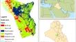
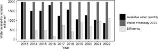
Climate change is one of the main factors that caused scarcity of fresh water phenomenon all over the world. The lack of water in major parts of Iraq affected all sectors that use water and cause obvious damages to ecosystems. Karbala province suffers from frequent water scarcity due to water scarcity and abnormally high temperatures. In the present study, remote sensing and GIS were applied to quantify water scarcity and evaluate its effects on vegetation in this fragile semiarid ecosystem. Analysis of hydrological data of the study area was carried out during 2013 to 2022 to compute water availability and shortage based on the criteria and requirements of water sector and environmental management in Iraq. Remotely sensed Landsat 8 images data were applied to measure changes on vegetation and the effects of water scarcity. Soil Adjusted Vegetation Index (SAVI) was employed to identify vegetation and detect its change. Results showed that the area witnessed decreasing in water availability compared to the reference year. Maximum available water reached 1977.535 million \({\text{m}}^{3}\) in 2013, while the minimum of 859.227 million \({\text{m}}^{3}\) was observed in 2022. The maximum and minimum vegetation area reached 535.610 \({\text{km}}^{2}\) and 430.605 \({\text{km}}^{2}\) in 2013 and 2022, respectively. Results indicated that all the years posterior to the reference year experienced water scarcity and vegetation damage, where the maximum and minimum water scarcity rates were 56% and 8% in 2022 and 2016, respectively. The maximum impact of water scarcity rate on vegetation was ca. 20% in both years 2015 and 2022. Water scarcity is constantly increasing over time, thus evaluating its impacts and forecasting its future specification will support decision-makers to take the necessary measures to mitigate its effects.


 分享
分享
 求助内容:
求助内容: 应助结果提醒方式:
 扫码关注我们
