Dhiego Gonçalves Pacheco, André Medeiros de Andrade
{"title":"Monitoring agricultural drought using different indices based on remote sensing data in the Brazilian biomes of Cerrado and Atlantic Forest","authors":"Dhiego Gonçalves Pacheco, André Medeiros de Andrade","doi":"10.1007/s00484-024-02731-4","DOIUrl":null,"url":null,"abstract":"<div><p>Several remote sensing indices have been used to monitor droughts, mainly in semi-arid regions with limited coverage by meteorological stations. The objective of this study was to estimate and monitor agricultural drought conditions in the Jequitinhonha Valley region, located in the Brazilian biomes of the Cerrado and Atlantic Forest, from 2001 to 2021, using vegetation indices and the meteorological drought index from remote sensing data. Linear regression was applied to analyze drought trends and Pearson’s correlation coefficient was applied to evaluate the relationship between vegetation indices and climatic conditions in agricultural areas using the Standardized Precipitation Index. The results revealed divergences in the occurrences of regional droughts, predominantly covering mild to moderate drought conditions. Analysis spatial of drought trends revealed a decreasing pattern, indicating an increase in drought in the Middle and Low Jequitinhonha sub-regions. On the other hand, a reduction in drought was observed in the High Jequitinhonha region. Notably, the Vegetation Condition Index demonstrated the most robust correlation with the Standardized Precipitation Index, with R values greater than 0.5 in all subregions of the study area. This index showed a strong association with precipitation, proving its suitability for monitoring agricultural drought in heterogeneous areas and with different climatic attributes. The use of remote sensing technology made it possible to detect regional variations in the spatio-temporal patterns of drought in the Jequitinhonha Valley. This vision helps in the implementation of personalized strategies and public policies, taking into account the particularities of each area, in order to mitigate the negative impacts of drought on agricultural activities in the region.</p></div>","PeriodicalId":588,"journal":{"name":"International Journal of Biometeorology","volume":"68 10","pages":"2069 - 2082"},"PeriodicalIF":2.6000,"publicationDate":"2024-07-08","publicationTypes":"Journal Article","fieldsOfStudy":null,"isOpenAccess":false,"openAccessPdf":"","citationCount":"0","resultStr":null,"platform":"Semanticscholar","paperid":null,"PeriodicalName":"International Journal of Biometeorology","FirstCategoryId":"89","ListUrlMain":"https://link.springer.com/article/10.1007/s00484-024-02731-4","RegionNum":3,"RegionCategory":"地球科学","ArticlePicture":[],"TitleCN":null,"AbstractTextCN":null,"PMCID":null,"EPubDate":"","PubModel":"","JCR":"Q2","JCRName":"BIOPHYSICS","Score":null,"Total":0}
引用次数: 0
Abstract
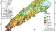
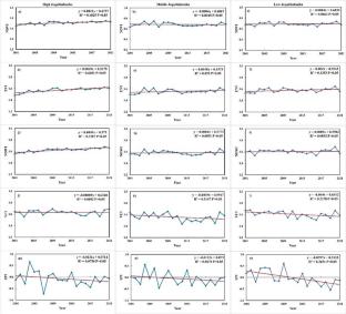
Several remote sensing indices have been used to monitor droughts, mainly in semi-arid regions with limited coverage by meteorological stations. The objective of this study was to estimate and monitor agricultural drought conditions in the Jequitinhonha Valley region, located in the Brazilian biomes of the Cerrado and Atlantic Forest, from 2001 to 2021, using vegetation indices and the meteorological drought index from remote sensing data. Linear regression was applied to analyze drought trends and Pearson’s correlation coefficient was applied to evaluate the relationship between vegetation indices and climatic conditions in agricultural areas using the Standardized Precipitation Index. The results revealed divergences in the occurrences of regional droughts, predominantly covering mild to moderate drought conditions. Analysis spatial of drought trends revealed a decreasing pattern, indicating an increase in drought in the Middle and Low Jequitinhonha sub-regions. On the other hand, a reduction in drought was observed in the High Jequitinhonha region. Notably, the Vegetation Condition Index demonstrated the most robust correlation with the Standardized Precipitation Index, with R values greater than 0.5 in all subregions of the study area. This index showed a strong association with precipitation, proving its suitability for monitoring agricultural drought in heterogeneous areas and with different climatic attributes. The use of remote sensing technology made it possible to detect regional variations in the spatio-temporal patterns of drought in the Jequitinhonha Valley. This vision helps in the implementation of personalized strategies and public policies, taking into account the particularities of each area, in order to mitigate the negative impacts of drought on agricultural activities in the region.
期刊介绍:
The Journal publishes original research papers, review articles and short communications on studies examining the interactions between living organisms and factors of the natural and artificial atmospheric environment.
Living organisms extend from single cell organisms, to plants and animals, including humans. The atmospheric environment includes climate and weather, electromagnetic radiation, and chemical and biological pollutants. The journal embraces basic and applied research and practical aspects such as living conditions, agriculture, forestry, and health.
The journal is published for the International Society of Biometeorology, and most membership categories include a subscription to the Journal.


 分享
分享
 求助内容:
求助内容: 应助结果提醒方式:
 扫码关注我们
