Hany Abdel-Maksoud, Tarek Abdel Aziz, Ahmed S. Elsharkawy, Osama Moursy
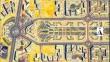
{"title":"Enhancing elevation surface precision through comparative analysis of photogrammetric software using UAV data: a case study in Egypt","authors":"Hany Abdel-Maksoud, Tarek Abdel Aziz, Ahmed S. Elsharkawy, Osama Moursy","doi":"10.1007/s12517-024-12033-z","DOIUrl":null,"url":null,"abstract":"<div><p>The introduction of unmanned aerial vehicles (UAVs) and their deployment as tools for terrain information gathering has prompted discussions regarding the quality of the resulting products and the potential for their extended applications in geomatics. This study specifically focuses on evaluating the utilization and capabilities of UAV photogrammetry in generating topographic maps, with a primary emphasis on assessing the accuracy of these maps. An area of approximately 2.65 km<sup>2</sup> of the New Administrative Capital in Cairo, Egypt, was captured using a DJI M300 RTK drone. Agisoft Metashape and Pix4Dmapper software were used to process digital images to produce orthophotos and digital surface models. The precision of direct geo-referencing was evaluated by utilizing common tie points extracted by the user and the onboard GPS camera positions recorded during flight. Horizontal and vertical RMSEs were measured at 0.069 m and 0.593 m for Pix4Dmapper and 0.062 m and 0.548 m for Agisoft Metashape, respectively. Notably, direct geo-referencing exhibited lower accuracy, particularly in the vertical dimension. In the 7-GCP scenario, when combined with indirect geo-referencing, both software packages achieved the highest accuracy, with radial RMSEs of 0.023 m and 0.054 m and vertical RMSEs of 0.038 m and 0.052 m, respectively, corresponding to a pixel size of 1.7–2.2 times the ground sampling distance (GSD). In summary, this study affirms the efficacy of utilizing UAV photogrammetry in creating digital maps, orthophotos, contour lines, digital terrain models, digital surface models, and line maps, all aligning with globally recognized standards.</p></div>","PeriodicalId":476,"journal":{"name":"Arabian Journal of Geosciences","volume":"17 8","pages":""},"PeriodicalIF":1.8270,"publicationDate":"2024-07-09","publicationTypes":"Journal Article","fieldsOfStudy":null,"isOpenAccess":false,"openAccessPdf":"","citationCount":"0","resultStr":null,"platform":"Semanticscholar","paperid":null,"PeriodicalName":"Arabian Journal of Geosciences","FirstCategoryId":"1085","ListUrlMain":"https://link.springer.com/article/10.1007/s12517-024-12033-z","RegionNum":0,"RegionCategory":null,"ArticlePicture":[],"TitleCN":null,"AbstractTextCN":null,"PMCID":null,"EPubDate":"","PubModel":"","JCR":"Q2","JCRName":"Earth and Planetary Sciences","Score":null,"Total":0}
引用次数: 0
Abstract
The introduction of unmanned aerial vehicles (UAVs) and their deployment as tools for terrain information gathering has prompted discussions regarding the quality of the resulting products and the potential for their extended applications in geomatics. This study specifically focuses on evaluating the utilization and capabilities of UAV photogrammetry in generating topographic maps, with a primary emphasis on assessing the accuracy of these maps. An area of approximately 2.65 km2 of the New Administrative Capital in Cairo, Egypt, was captured using a DJI M300 RTK drone. Agisoft Metashape and Pix4Dmapper software were used to process digital images to produce orthophotos and digital surface models. The precision of direct geo-referencing was evaluated by utilizing common tie points extracted by the user and the onboard GPS camera positions recorded during flight. Horizontal and vertical RMSEs were measured at 0.069 m and 0.593 m for Pix4Dmapper and 0.062 m and 0.548 m for Agisoft Metashape, respectively. Notably, direct geo-referencing exhibited lower accuracy, particularly in the vertical dimension. In the 7-GCP scenario, when combined with indirect geo-referencing, both software packages achieved the highest accuracy, with radial RMSEs of 0.023 m and 0.054 m and vertical RMSEs of 0.038 m and 0.052 m, respectively, corresponding to a pixel size of 1.7–2.2 times the ground sampling distance (GSD). In summary, this study affirms the efficacy of utilizing UAV photogrammetry in creating digital maps, orthophotos, contour lines, digital terrain models, digital surface models, and line maps, all aligning with globally recognized standards.
期刊介绍:
The Arabian Journal of Geosciences is the official journal of the Saudi Society for Geosciences and publishes peer-reviewed original and review articles on the entire range of Earth Science themes, focused on, but not limited to, those that have regional significance to the Middle East and the Euro-Mediterranean Zone.
Key topics therefore include; geology, hydrogeology, earth system science, petroleum sciences, geophysics, seismology and crustal structures, tectonics, sedimentology, palaeontology, metamorphic and igneous petrology, natural hazards, environmental sciences and sustainable development, geoarchaeology, geomorphology, paleo-environment studies, oceanography, atmospheric sciences, GIS and remote sensing, geodesy, mineralogy, volcanology, geochemistry and metallogenesis.


 分享
分享
 求助内容:
求助内容: 应助结果提醒方式:
 扫码关注我们
