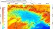
{"title":"Statistical modeling and mapping of rainfall in the endorheic basins of Northern Algeria: a comparison of spatial interpolation methods","authors":"Azeddine Guidoum","doi":"10.1007/s11600-024-01392-6","DOIUrl":null,"url":null,"abstract":"<div><p>The creation of rainfall maps often relies on preliminary spatial interpolation. Significant deviations from the real distribution of rainfall are likely to occur due to the wide variety of interpolation methods, the effectiveness of which may vary. The main objective of this study is to find the best interpolation method to estimate the spatial distribution of rainfall in the Chott El Hodna basin (25,834 km<sup>2</sup>), typical of endorheic basins in Algeria. The rainfall database consisted of 42 years of monthly observations from 52 stations (1975–2017). Eight spatial interpolation models were compared, six of which were deterministic and two stochastic. Deterministic models include nearest neighbor, inverse distance weighting, local polynomial, minimum curvature, thin plate spline, and natural neighbor. The stochastic models are ordinary kriging and regression-kriging (RK). RK uniquely incorporates additional information about the geotopographical environment of the basin. The forecasting performance of each method was evaluated using statistical cross-validation indicators, as well as visual analysis and comparison with previously published isohyet maps. The evaluation concluded that the RK model is the most appropriate for producing a map of annual mean rainfall in the Chott El Hodna basin. In addition, this map covering the period from 1975 to 2017 revealed a significant average drop in rainfall: 31% compared to the periods 1913–1938 and 1913–1963, and 24% relative to the period 1922–1960/1969–1989. Further research is needed to determine the causes of these trends, assess their long-term impact, and develop effective adaptation strategies.</p></div>","PeriodicalId":6988,"journal":{"name":"Acta Geophysica","volume":"73 2","pages":"1679 - 1699"},"PeriodicalIF":2.1000,"publicationDate":"2024-07-15","publicationTypes":"Journal Article","fieldsOfStudy":null,"isOpenAccess":false,"openAccessPdf":"","citationCount":"0","resultStr":null,"platform":"Semanticscholar","paperid":null,"PeriodicalName":"Acta Geophysica","FirstCategoryId":"89","ListUrlMain":"https://link.springer.com/article/10.1007/s11600-024-01392-6","RegionNum":4,"RegionCategory":"地球科学","ArticlePicture":[],"TitleCN":null,"AbstractTextCN":null,"PMCID":null,"EPubDate":"","PubModel":"","JCR":"","JCRName":"","Score":null,"Total":0}
引用次数: 0
Abstract
The creation of rainfall maps often relies on preliminary spatial interpolation. Significant deviations from the real distribution of rainfall are likely to occur due to the wide variety of interpolation methods, the effectiveness of which may vary. The main objective of this study is to find the best interpolation method to estimate the spatial distribution of rainfall in the Chott El Hodna basin (25,834 km2), typical of endorheic basins in Algeria. The rainfall database consisted of 42 years of monthly observations from 52 stations (1975–2017). Eight spatial interpolation models were compared, six of which were deterministic and two stochastic. Deterministic models include nearest neighbor, inverse distance weighting, local polynomial, minimum curvature, thin plate spline, and natural neighbor. The stochastic models are ordinary kriging and regression-kriging (RK). RK uniquely incorporates additional information about the geotopographical environment of the basin. The forecasting performance of each method was evaluated using statistical cross-validation indicators, as well as visual analysis and comparison with previously published isohyet maps. The evaluation concluded that the RK model is the most appropriate for producing a map of annual mean rainfall in the Chott El Hodna basin. In addition, this map covering the period from 1975 to 2017 revealed a significant average drop in rainfall: 31% compared to the periods 1913–1938 and 1913–1963, and 24% relative to the period 1922–1960/1969–1989. Further research is needed to determine the causes of these trends, assess their long-term impact, and develop effective adaptation strategies.
雨量图的创建通常依赖于初步的空间插值。由于各种各样的插值方法,其有效性可能会有所不同,因此可能会出现与实际降雨量分布的显著偏差。本研究的主要目的是寻找最佳插值方法来估计阿尔及利亚典型内陆盆地Chott El Hodna盆地(25,834 km2)的降雨空间分布。降雨数据库由52个站点(1975-2017)42年的月度观测数据组成。比较了8种空间插值模型,其中6种为确定性插值模型,2种为随机插值模型。确定性模型包括最近邻模型、逆距离加权模型、局部多项式模型、最小曲率模型、薄板样条模型和自然近邻模型。随机模型分为普通克里格模型和回归克里格模型。RK独特地纳入了有关盆地地理地形环境的额外信息。通过统计交叉验证指标、视觉分析和与先前发表的等雨量图的比较,对每种方法的预测性能进行了评估。评价的结论是,RK模型最适合制作Chott El Hodna盆地的年平均降雨量图。此外,这张涵盖1975年至2017年期间的地图显示,降雨量平均下降显著:与1913-1938年和1913-1963年期间相比下降31%,与1922-1960/1969-1989年期间相比下降24%。需要进一步的研究来确定这些趋势的原因,评估其长期影响,并制定有效的适应战略。
期刊介绍:
Acta Geophysica is open to all kinds of manuscripts including research and review articles, short communications, comments to published papers, letters to the Editor as well as book reviews. Some of the issues are fully devoted to particular topics; we do encourage proposals for such topical issues. We accept submissions from scientists world-wide, offering high scientific and editorial standard and comprehensive treatment of the discussed topics.


 分享
分享
 求助内容:
求助内容: 应助结果提醒方式:
 扫码关注我们
