I. P. Babayants, V. O. Mikhailov, E. P. Timoshkina, A. A. Baryakh
{"title":"Shear Trough Depth and Geometry Relation Determined from Satellite Radar Images from One or Two Orbits","authors":"I. P. Babayants, V. O. Mikhailov, E. P. Timoshkina, A. A. Baryakh","doi":"10.1134/S1069351324700514","DOIUrl":null,"url":null,"abstract":"<p><b>Abstract</b>—The subsidence of the Earth’s surface, calculated from the theoretical model of a shear trough above a longwall developed by pillar and room caving are compared with displacements that can be estimated from trough monitoring using satellite images acquired from a single and two orbits. It is shown that the transverse and longitudinal axes of the trough do not shift when subsidence is calculated using data from descending and ascending orbits together. The maximum subsidence magnitude is determined almost without error. Errors in the reconstruction of the trough geometry appear where there is a significant northern displacement component, which, due to the characteristics of satellite radar imaging, is usually neglected. For the north‒south and west‒east trending troughs, these are their northern and southern boundaries; and for a trough trending from northwest to southeast, these are its northernmost and southernmost corners. In the maps of displacements in the direction towards the satellite (Line-of-Sight displacements, LOS), as well as in the subvertical displacement maps <i>U</i><sub>subv</sub> calculated using images from a single orbit, assuming that horizontal surface displacements are much smaller than vertical ones, the subsiding and uplifting areas are always shifted towards the satellite. Namely, in the displacement maps based on satellite images acquired from ascending and descending orbits these areas are always shifted to the west and east, respectively. The displacement magnitude is 50–60 m. The displacement direction of the longitudinal and transverse axes of the trough in the maps of subvertical displacements <i>U</i><sub>subv</sub> depends on their strike. The displacements of the trough axes relative to their real ground position should be taken into account when estimating the location of a shear trough from the maps <i>U</i><sub>subv</sub> of subvertical displacements derived from images from one orbit. In these maps, the maximum subsidence magnitude is approximately 10% larger than the displacements calculated from the trough model.</p>","PeriodicalId":602,"journal":{"name":"Izvestiya, Physics of the Solid Earth","volume":"60 3","pages":"508 - 517"},"PeriodicalIF":1.0000,"publicationDate":"2024-07-18","publicationTypes":"Journal Article","fieldsOfStudy":null,"isOpenAccess":false,"openAccessPdf":"","citationCount":"0","resultStr":null,"platform":"Semanticscholar","paperid":null,"PeriodicalName":"Izvestiya, Physics of the Solid Earth","FirstCategoryId":"89","ListUrlMain":"https://link.springer.com/article/10.1134/S1069351324700514","RegionNum":4,"RegionCategory":"地球科学","ArticlePicture":[],"TitleCN":null,"AbstractTextCN":null,"PMCID":null,"EPubDate":"","PubModel":"","JCR":"Q4","JCRName":"GEOCHEMISTRY & GEOPHYSICS","Score":null,"Total":0}
引用次数: 0
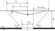
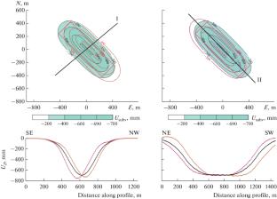
Abstract—The subsidence of the Earth’s surface, calculated from the theoretical model of a shear trough above a longwall developed by pillar and room caving are compared with displacements that can be estimated from trough monitoring using satellite images acquired from a single and two orbits. It is shown that the transverse and longitudinal axes of the trough do not shift when subsidence is calculated using data from descending and ascending orbits together. The maximum subsidence magnitude is determined almost without error. Errors in the reconstruction of the trough geometry appear where there is a significant northern displacement component, which, due to the characteristics of satellite radar imaging, is usually neglected. For the north‒south and west‒east trending troughs, these are their northern and southern boundaries; and for a trough trending from northwest to southeast, these are its northernmost and southernmost corners. In the maps of displacements in the direction towards the satellite (Line-of-Sight displacements, LOS), as well as in the subvertical displacement maps Usubv calculated using images from a single orbit, assuming that horizontal surface displacements are much smaller than vertical ones, the subsiding and uplifting areas are always shifted towards the satellite. Namely, in the displacement maps based on satellite images acquired from ascending and descending orbits these areas are always shifted to the west and east, respectively. The displacement magnitude is 50–60 m. The displacement direction of the longitudinal and transverse axes of the trough in the maps of subvertical displacements Usubv depends on their strike. The displacements of the trough axes relative to their real ground position should be taken into account when estimating the location of a shear trough from the maps Usubv of subvertical displacements derived from images from one orbit. In these maps, the maximum subsidence magnitude is approximately 10% larger than the displacements calculated from the trough model.
期刊介绍:
Izvestiya, Physics of the Solid Earth is an international peer reviewed journal that publishes results of original theoretical and experimental research in relevant areas of the physics of the Earth''s interior and applied geophysics. The journal welcomes manuscripts from all countries in the English or Russian language.


 分享
分享
 求助内容:
求助内容: 应助结果提醒方式:
 扫码关注我们
