Philippe Hensel, Donald R. Cahoon, Glenn Guntenspergen, Laura Mitchell, Matt Whitbeck, Galen Scott
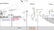
{"title":"Incorporating Measurements of Vertical Land Motion in Wetland Surface Elevation Change Analyses","authors":"Philippe Hensel, Donald R. Cahoon, Glenn Guntenspergen, Laura Mitchell, Matt Whitbeck, Galen Scott","doi":"10.1007/s12237-024-01406-y","DOIUrl":null,"url":null,"abstract":"<p>We compared elevation trajectories from 14 rod surface elevation table (RSET) stations and 60 real-time kinematic (RTK) global positioning system (GPS) transects within the Blackwater National Wildlife Refuge (BNWR) from 2010–2013. The results were similar, 7.3 ± 0.9 (mean ± standard error; RSET) versus 6.2 ± 0.6 mm year<sup>−1</sup> (RTK) (<i>P</i> = 0.216), and were greater than relative sea level rise (RSLR) computed at the nearest long-term tide station (3.9 ± 0.29 mm year<sup>−1</sup>). Despite having shown elevation gain, these wetlands continue to drown and convert to open water. Episodic, multi-day GPS measurements on geodetic control marks at BNWR between 2005 and 2023 revealed a substantial vertical land motion (VLM) signal. From 2005 to 2015, three reference marks used to control the 2010–2013 RTK study lost on average 6.0 ± 0.7 mm year<sup>−1</sup>, corresponding to 80% and 94% of the elevation gain measured by the RSET and RTK techniques, respectively. The longer 18-year subsidence trend measured on one of these marks was lower, 3.9 ± 0.7 mm year<sup>−1</sup>, highlighting important interannual variability. Wetland elevation change measurements need to account for VLM occurring below the reference marks used to measure elevation change. Estimates from the nearest long-term tide station may not be applicable to the wetland if the tide station is in a different geological setting. At BNWR, VLM was higher than the VLM at the Cambridge tide station, which helps explain why wetlands at BNWR are not keeping pace with RSLR despite the measured high rates of elevation gain.\n</p>","PeriodicalId":11921,"journal":{"name":"Estuaries and Coasts","volume":"41 1","pages":""},"PeriodicalIF":2.3000,"publicationDate":"2024-07-31","publicationTypes":"Journal Article","fieldsOfStudy":null,"isOpenAccess":false,"openAccessPdf":"","citationCount":"0","resultStr":null,"platform":"Semanticscholar","paperid":null,"PeriodicalName":"Estuaries and Coasts","FirstCategoryId":"93","ListUrlMain":"https://doi.org/10.1007/s12237-024-01406-y","RegionNum":3,"RegionCategory":"环境科学与生态学","ArticlePicture":[],"TitleCN":null,"AbstractTextCN":null,"PMCID":null,"EPubDate":"","PubModel":"","JCR":"Q3","JCRName":"ENVIRONMENTAL SCIENCES","Score":null,"Total":0}
引用次数: 0
Abstract
We compared elevation trajectories from 14 rod surface elevation table (RSET) stations and 60 real-time kinematic (RTK) global positioning system (GPS) transects within the Blackwater National Wildlife Refuge (BNWR) from 2010–2013. The results were similar, 7.3 ± 0.9 (mean ± standard error; RSET) versus 6.2 ± 0.6 mm year−1 (RTK) (P = 0.216), and were greater than relative sea level rise (RSLR) computed at the nearest long-term tide station (3.9 ± 0.29 mm year−1). Despite having shown elevation gain, these wetlands continue to drown and convert to open water. Episodic, multi-day GPS measurements on geodetic control marks at BNWR between 2005 and 2023 revealed a substantial vertical land motion (VLM) signal. From 2005 to 2015, three reference marks used to control the 2010–2013 RTK study lost on average 6.0 ± 0.7 mm year−1, corresponding to 80% and 94% of the elevation gain measured by the RSET and RTK techniques, respectively. The longer 18-year subsidence trend measured on one of these marks was lower, 3.9 ± 0.7 mm year−1, highlighting important interannual variability. Wetland elevation change measurements need to account for VLM occurring below the reference marks used to measure elevation change. Estimates from the nearest long-term tide station may not be applicable to the wetland if the tide station is in a different geological setting. At BNWR, VLM was higher than the VLM at the Cambridge tide station, which helps explain why wetlands at BNWR are not keeping pace with RSLR despite the measured high rates of elevation gain.
期刊介绍:
Estuaries and Coasts is the journal of the Coastal and Estuarine Research Federation (CERF). Begun in 1977 as Chesapeake Science, the journal has gradually expanded its scope and circulation. Today, the journal publishes scholarly manuscripts on estuarine and near coastal ecosystems at the interface between the land and the sea where there are tidal fluctuations or sea water is diluted by fresh water. The interface is broadly defined to include estuaries and nearshore coastal waters including lagoons, wetlands, tidal fresh water, shores and beaches, but not the continental shelf. The journal covers research on physical, chemical, geological or biological processes, as well as applications to management of estuaries and coasts. The journal publishes original research findings, reviews and perspectives, techniques, comments, and management applications. Estuaries and Coasts will consider properly carried out studies that present inconclusive findings or document a failed replication of previously published work. Submissions that are primarily descriptive, strongly place-based, or only report on development of models or new methods without detailing their applications fall outside the scope of the journal.


 分享
分享
 求助内容:
求助内容: 应助结果提醒方式:
 扫码关注我们
