{"title":"A robust ensemble of hybrid and bivariate statistical models for flood prediction mapping in Lower Damodar River Basin of India","authors":"Shuayb Abdinour Osman , Jayanta Das","doi":"10.1016/j.geogeo.2024.100312","DOIUrl":null,"url":null,"abstract":"<div><p>This research explores flood prediction in the Lower Damodar River Basin (LDRB) using a hybrid ensemble of a Naïve Bayes Tree (NBT) and five bivariate statistical models such as Evidential Belief Function (EBF), Index of Entropy (IOE), Frequency Ratio (FR), Statistical Index (SI), and Modified Information Value (MIV). A total of 348 flood locations and 15 conditioning factors including hydrological, topographical and land cover were considered for this analysis. To ensure the precision of model predictions, a multicollinearity assessment was executed. Receiver operating characteristic (ROC) curve, area under curve (AUC), mean absolute error (MAE), mean squared error (MSE), and root mean squared error (RMSE) were performed to compare and asses each of the models all. The results reveal that all models performed well in creating flood hazard maps with AUC >0.8 and RMSE <0.4. FR and EBF models demonstrated the highest predictive accuracy (AUC=0.85), followed by the IOE, SI, and MIV models. The ensemble of NBT with bivariate models shows promising results, showcasing reduced error metrics and improved accuracy for the IOE, SI, and MIV models. This study highlights the potential of ensemble models in flood hazard prediction, offering valuable insights for global flood risk management. The successful application of these data-driven models showcases their importance in forecasting flood risks, aiding decision-makers and planners in developing more effective flood mitigation strategies.</p></div>","PeriodicalId":100582,"journal":{"name":"Geosystems and Geoenvironment","volume":"3 4","pages":"Article 100312"},"PeriodicalIF":0.0000,"publicationDate":"2024-08-23","publicationTypes":"Journal Article","fieldsOfStudy":null,"isOpenAccess":false,"openAccessPdf":"https://www.sciencedirect.com/science/article/pii/S2772883824000621/pdfft?md5=c5d1c08f3c4d9022ddbf80e95b6d5637&pid=1-s2.0-S2772883824000621-main.pdf","citationCount":"0","resultStr":null,"platform":"Semanticscholar","paperid":null,"PeriodicalName":"Geosystems and Geoenvironment","FirstCategoryId":"1085","ListUrlMain":"https://www.sciencedirect.com/science/article/pii/S2772883824000621","RegionNum":0,"RegionCategory":null,"ArticlePicture":[],"TitleCN":null,"AbstractTextCN":null,"PMCID":null,"EPubDate":"","PubModel":"","JCR":"","JCRName":"","Score":null,"Total":0}
引用次数: 0
Abstract
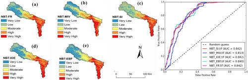
This research explores flood prediction in the Lower Damodar River Basin (LDRB) using a hybrid ensemble of a Naïve Bayes Tree (NBT) and five bivariate statistical models such as Evidential Belief Function (EBF), Index of Entropy (IOE), Frequency Ratio (FR), Statistical Index (SI), and Modified Information Value (MIV). A total of 348 flood locations and 15 conditioning factors including hydrological, topographical and land cover were considered for this analysis. To ensure the precision of model predictions, a multicollinearity assessment was executed. Receiver operating characteristic (ROC) curve, area under curve (AUC), mean absolute error (MAE), mean squared error (MSE), and root mean squared error (RMSE) were performed to compare and asses each of the models all. The results reveal that all models performed well in creating flood hazard maps with AUC >0.8 and RMSE <0.4. FR and EBF models demonstrated the highest predictive accuracy (AUC=0.85), followed by the IOE, SI, and MIV models. The ensemble of NBT with bivariate models shows promising results, showcasing reduced error metrics and improved accuracy for the IOE, SI, and MIV models. This study highlights the potential of ensemble models in flood hazard prediction, offering valuable insights for global flood risk management. The successful application of these data-driven models showcases their importance in forecasting flood risks, aiding decision-makers and planners in developing more effective flood mitigation strategies.


 分享
分享

 求助内容:
求助内容: 应助结果提醒方式:
 扫码关注我们
