Jakub Langhammer , Theodora Lendzioch , Lukáš Vlček
{"title":"Montane peatland response to drought: Evidence from multispectral and thermal UAS monitoring","authors":"Jakub Langhammer , Theodora Lendzioch , Lukáš Vlček","doi":"10.1016/j.ecolind.2024.112587","DOIUrl":null,"url":null,"abstract":"<div><p>This paper investigates the response of mid-latitude montane peatlands to climate warming, focusing on changes occurring in a montane peat bog during a drought period. Unmanned Aerial Systems (UAS) equipped with multispectral and thermal sensors were used for high-resolution monitoring to analyze qualitative changes within the peat bog and their spatial distribution. The study was conducted in the Rokytka mountain peat bog in Šumava National Park, Czech Republic, which is one of the largest mountain peat bog complexes in Central Europe. Monitoring took place during the 2019 vegetation season, coinciding with the peak of the 2015–2019 drought. The recurrent UAS imaging campaigns were complemented by continuous hydrological and hydropedological monitoring and in-situ calibration measurements. The findings revealed diverging responses of montane peatlands to climate change across different functional zones of the peat bog. UAS thermal mapping identified distinct land surface temperature variations across various vegetation categories under different conditions. Notably, ponds and waterlogged areas displayed a stabilizing effect on land surface temperature variability, though they exhibited different absolute temperatures. In contrast, shallow waterlogged areas exhibited surface temperatures akin to dry open peat areas. Multispectral UAS monitoring demonstrated significant transitions among the peat bog zones in response to heat and drought propagation. The most pronounced changes occurred in shallow waterlogged areas, which shrank notably from 22.8% to 4.5%, while bare peat expanded from 26.8% to 45.5% during the 2019 drought season. High-resolution thermal and multispectral monitoring has revealed the scope and magnitude of the intra-peatland responses to drought and heat waves and serves as a sensible indicator of environmental changes of peatlands. It has disclosed a large cumulative effect of change in an environment composed of highly heterogeneous and subtle structures. The results highlighted the effectiveness of UAS monitoring in understanding the extent of change in montane peatlands as a fragile environment exposed to the effects of climate change.</p></div>","PeriodicalId":11459,"journal":{"name":"Ecological Indicators","volume":"167 ","pages":"Article 112587"},"PeriodicalIF":7.0000,"publicationDate":"2024-10-01","publicationTypes":"Journal Article","fieldsOfStudy":null,"isOpenAccess":false,"openAccessPdf":"https://www.sciencedirect.com/science/article/pii/S1470160X24010446/pdfft?md5=2a7aacb777c4a6e766ddcff7fc35ab3d&pid=1-s2.0-S1470160X24010446-main.pdf","citationCount":"0","resultStr":null,"platform":"Semanticscholar","paperid":null,"PeriodicalName":"Ecological Indicators","FirstCategoryId":"93","ListUrlMain":"https://www.sciencedirect.com/science/article/pii/S1470160X24010446","RegionNum":2,"RegionCategory":"环境科学与生态学","ArticlePicture":[],"TitleCN":null,"AbstractTextCN":null,"PMCID":null,"EPubDate":"2024/9/13 0:00:00","PubModel":"Epub","JCR":"Q1","JCRName":"ENVIRONMENTAL SCIENCES","Score":null,"Total":0}
引用次数: 0
Abstract
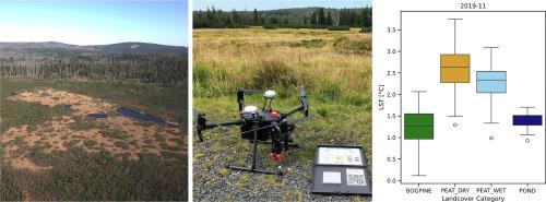
This paper investigates the response of mid-latitude montane peatlands to climate warming, focusing on changes occurring in a montane peat bog during a drought period. Unmanned Aerial Systems (UAS) equipped with multispectral and thermal sensors were used for high-resolution monitoring to analyze qualitative changes within the peat bog and their spatial distribution. The study was conducted in the Rokytka mountain peat bog in Šumava National Park, Czech Republic, which is one of the largest mountain peat bog complexes in Central Europe. Monitoring took place during the 2019 vegetation season, coinciding with the peak of the 2015–2019 drought. The recurrent UAS imaging campaigns were complemented by continuous hydrological and hydropedological monitoring and in-situ calibration measurements. The findings revealed diverging responses of montane peatlands to climate change across different functional zones of the peat bog. UAS thermal mapping identified distinct land surface temperature variations across various vegetation categories under different conditions. Notably, ponds and waterlogged areas displayed a stabilizing effect on land surface temperature variability, though they exhibited different absolute temperatures. In contrast, shallow waterlogged areas exhibited surface temperatures akin to dry open peat areas. Multispectral UAS monitoring demonstrated significant transitions among the peat bog zones in response to heat and drought propagation. The most pronounced changes occurred in shallow waterlogged areas, which shrank notably from 22.8% to 4.5%, while bare peat expanded from 26.8% to 45.5% during the 2019 drought season. High-resolution thermal and multispectral monitoring has revealed the scope and magnitude of the intra-peatland responses to drought and heat waves and serves as a sensible indicator of environmental changes of peatlands. It has disclosed a large cumulative effect of change in an environment composed of highly heterogeneous and subtle structures. The results highlighted the effectiveness of UAS monitoring in understanding the extent of change in montane peatlands as a fragile environment exposed to the effects of climate change.
期刊介绍:
The ultimate aim of Ecological Indicators is to integrate the monitoring and assessment of ecological and environmental indicators with management practices. The journal provides a forum for the discussion of the applied scientific development and review of traditional indicator approaches as well as for theoretical, modelling and quantitative applications such as index development. Research into the following areas will be published.
• All aspects of ecological and environmental indicators and indices.
• New indicators, and new approaches and methods for indicator development, testing and use.
• Development and modelling of indices, e.g. application of indicator suites across multiple scales and resources.
• Analysis and research of resource, system- and scale-specific indicators.
• Methods for integration of social and other valuation metrics for the production of scientifically rigorous and politically-relevant assessments using indicator-based monitoring and assessment programs.
• How research indicators can be transformed into direct application for management purposes.
• Broader assessment objectives and methods, e.g. biodiversity, biological integrity, and sustainability, through the use of indicators.
• Resource-specific indicators such as landscape, agroecosystems, forests, wetlands, etc.


 分享
分享
 求助内容:
求助内容: 应助结果提醒方式:
 扫码关注我们
