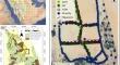
{"title":"Subsurface Characterization of the Al-Hassa National Park, Eastern Saudi Arabia, Using Multi-Geophysical Methods","authors":"Abid Khogali, Konstantinos Chavanidis, Panagiotis Kirmizakis, Alexandros Stampolidis, Abdul Latif Ashadi, Tilman Hanstein, Emin Candansayar, Pantelis Soupios","doi":"10.1007/s13369-024-09584-4","DOIUrl":null,"url":null,"abstract":"<div><p>Al-Hassa, located in eastern Saudi Arabia, hosts the world’s largest oasis and naturally irrigated land. Historically, 280 natural springs irrigated farms, with varying water quality suggesting a complex subsurface regime. To explore this, a multi-geophysical approach was applied in a remote part of the Al-Hassa National Park, where minimum cultural noise from agricultural and industrial activities is present. Five geophysical methods—210 gravity stations, a 3.6 km magnetic profile, 46 magnetotelluric (MT), six audio-magnetotelluric (AMT), and 35 transient electromagnetic (TEM) stations—were acquired to reconstruct a 3D subsurface model. Processing and integration of gravity and electromagnetic data revealed a complex underground structure with lateral resistivity (p<sub>r</sub>) discontinuities, a possible salt dome structure, and fracture zones affecting groundwater flow. Key findings include low-resistivity anomalies indicating potential basins filled with low-density (p<sub>d</sub>) sediments and high-resistivity zones suggesting basement rocks. The MT model reaches 4.5 km depth (z), while the 2D gravity model extends to 1.8 km. Low-resistivity zones in the MT data correlate with high-potential aquifers. The comparison of the gravity, TEM, and MT data showed good agreement, confirming the subsurface features. These results indicate significant hydrogeological complexity, impacting groundwater management and resource exploration. This comprehensive modeling approach provides insights into the qualitative hydrogeological characteristics and deeper subsurface conditions, potentially impacting the world’s largest conventional oilfield, Ghawar, located in the vicinity of the study area (A).</p></div>","PeriodicalId":54354,"journal":{"name":"Arabian Journal for Science and Engineering","volume":"50 1","pages":"433 - 452"},"PeriodicalIF":2.9000,"publicationDate":"2024-09-12","publicationTypes":"Journal Article","fieldsOfStudy":null,"isOpenAccess":false,"openAccessPdf":"","citationCount":"0","resultStr":null,"platform":"Semanticscholar","paperid":null,"PeriodicalName":"Arabian Journal for Science and Engineering","FirstCategoryId":"103","ListUrlMain":"https://link.springer.com/article/10.1007/s13369-024-09584-4","RegionNum":4,"RegionCategory":"综合性期刊","ArticlePicture":[],"TitleCN":null,"AbstractTextCN":null,"PMCID":null,"EPubDate":"","PubModel":"","JCR":"Q2","JCRName":"MULTIDISCIPLINARY SCIENCES","Score":null,"Total":0}
引用次数: 0
Abstract
Al-Hassa, located in eastern Saudi Arabia, hosts the world’s largest oasis and naturally irrigated land. Historically, 280 natural springs irrigated farms, with varying water quality suggesting a complex subsurface regime. To explore this, a multi-geophysical approach was applied in a remote part of the Al-Hassa National Park, where minimum cultural noise from agricultural and industrial activities is present. Five geophysical methods—210 gravity stations, a 3.6 km magnetic profile, 46 magnetotelluric (MT), six audio-magnetotelluric (AMT), and 35 transient electromagnetic (TEM) stations—were acquired to reconstruct a 3D subsurface model. Processing and integration of gravity and electromagnetic data revealed a complex underground structure with lateral resistivity (pr) discontinuities, a possible salt dome structure, and fracture zones affecting groundwater flow. Key findings include low-resistivity anomalies indicating potential basins filled with low-density (pd) sediments and high-resistivity zones suggesting basement rocks. The MT model reaches 4.5 km depth (z), while the 2D gravity model extends to 1.8 km. Low-resistivity zones in the MT data correlate with high-potential aquifers. The comparison of the gravity, TEM, and MT data showed good agreement, confirming the subsurface features. These results indicate significant hydrogeological complexity, impacting groundwater management and resource exploration. This comprehensive modeling approach provides insights into the qualitative hydrogeological characteristics and deeper subsurface conditions, potentially impacting the world’s largest conventional oilfield, Ghawar, located in the vicinity of the study area (A).
期刊介绍:
King Fahd University of Petroleum & Minerals (KFUPM) partnered with Springer to publish the Arabian Journal for Science and Engineering (AJSE).
AJSE, which has been published by KFUPM since 1975, is a recognized national, regional and international journal that provides a great opportunity for the dissemination of research advances from the Kingdom of Saudi Arabia, MENA and the world.


 分享
分享
 求助内容:
求助内容: 应助结果提醒方式:
 扫码关注我们
