Helena Calatrava , Bhavya Duvvuri , Haoqing Li , Ricardo Borsoi , Edward Beighley , Deniz Erdoğmuş , Pau Closas , Tales Imbiriba
{"title":"Recursive classification of satellite imaging time-series: An application to land cover mapping","authors":"Helena Calatrava , Bhavya Duvvuri , Haoqing Li , Ricardo Borsoi , Edward Beighley , Deniz Erdoğmuş , Pau Closas , Tales Imbiriba","doi":"10.1016/j.isprsjprs.2024.09.003","DOIUrl":null,"url":null,"abstract":"<div><div>Despite the extensive body of literature focused on remote sensing applications for land cover mapping and the availability of high-resolution satellite imagery, methods for continuously updating classification maps in real-time remain limited, especially when training data is scarce. This paper introduces the recursive Bayesian classifier (RBC), which converts any instantaneous classifier into a robust online method through a probabilistic framework that is resilient to non-informative image variations. Three experiments are conducted using Sentinel-2 data: water mapping of the Oroville Dam in California and the Charles River basin in Massachusetts, and deforestation detection in the Amazon. RBC is applied to a Gaussian mixture model (GMM), logistic regression (LR), and our proposed spectral index classifier (SIC). Results show that RBC significantly enhances classifier robustness in multitemporal settings under challenging conditions, such as cloud cover and cyanobacterial blooms. Specifically, balanced classification accuracy improves by up to 26.95% for SIC, 12.4% for GMM, and 13.81% for LR in water mapping, and by 15.25%, 14.17%, and 14.7% in deforestation detection. Moreover, without additional training data, RBC improves the performance of the state-of-the-art DeepWaterMap and WatNet algorithms by up to 9.62% and 11.03%. These benefits are provided by RBC while requiring minimal supervision and maintaining a low computational cost that remains constant for each time step regardless of the time-series length.</div></div>","PeriodicalId":50269,"journal":{"name":"ISPRS Journal of Photogrammetry and Remote Sensing","volume":"218 ","pages":"Pages 447-465"},"PeriodicalIF":12.2000,"publicationDate":"2024-12-01","publicationTypes":"Journal Article","fieldsOfStudy":null,"isOpenAccess":false,"openAccessPdf":"","citationCount":"0","resultStr":null,"platform":"Semanticscholar","paperid":null,"PeriodicalName":"ISPRS Journal of Photogrammetry and Remote Sensing","FirstCategoryId":"5","ListUrlMain":"https://www.sciencedirect.com/science/article/pii/S0924271624003381","RegionNum":1,"RegionCategory":"地球科学","ArticlePicture":[],"TitleCN":null,"AbstractTextCN":null,"PMCID":null,"EPubDate":"2024/9/27 0:00:00","PubModel":"Epub","JCR":"Q1","JCRName":"GEOGRAPHY, PHYSICAL","Score":null,"Total":0}
引用次数: 0
Abstract
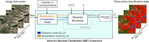
Despite the extensive body of literature focused on remote sensing applications for land cover mapping and the availability of high-resolution satellite imagery, methods for continuously updating classification maps in real-time remain limited, especially when training data is scarce. This paper introduces the recursive Bayesian classifier (RBC), which converts any instantaneous classifier into a robust online method through a probabilistic framework that is resilient to non-informative image variations. Three experiments are conducted using Sentinel-2 data: water mapping of the Oroville Dam in California and the Charles River basin in Massachusetts, and deforestation detection in the Amazon. RBC is applied to a Gaussian mixture model (GMM), logistic regression (LR), and our proposed spectral index classifier (SIC). Results show that RBC significantly enhances classifier robustness in multitemporal settings under challenging conditions, such as cloud cover and cyanobacterial blooms. Specifically, balanced classification accuracy improves by up to 26.95% for SIC, 12.4% for GMM, and 13.81% for LR in water mapping, and by 15.25%, 14.17%, and 14.7% in deforestation detection. Moreover, without additional training data, RBC improves the performance of the state-of-the-art DeepWaterMap and WatNet algorithms by up to 9.62% and 11.03%. These benefits are provided by RBC while requiring minimal supervision and maintaining a low computational cost that remains constant for each time step regardless of the time-series length.
期刊介绍:
The ISPRS Journal of Photogrammetry and Remote Sensing (P&RS) serves as the official journal of the International Society for Photogrammetry and Remote Sensing (ISPRS). It acts as a platform for scientists and professionals worldwide who are involved in various disciplines that utilize photogrammetry, remote sensing, spatial information systems, computer vision, and related fields. The journal aims to facilitate communication and dissemination of advancements in these disciplines, while also acting as a comprehensive source of reference and archive.
P&RS endeavors to publish high-quality, peer-reviewed research papers that are preferably original and have not been published before. These papers can cover scientific/research, technological development, or application/practical aspects. Additionally, the journal welcomes papers that are based on presentations from ISPRS meetings, as long as they are considered significant contributions to the aforementioned fields.
In particular, P&RS encourages the submission of papers that are of broad scientific interest, showcase innovative applications (especially in emerging fields), have an interdisciplinary focus, discuss topics that have received limited attention in P&RS or related journals, or explore new directions in scientific or professional realms. It is preferred that theoretical papers include practical applications, while papers focusing on systems and applications should include a theoretical background.


 分享
分享
 求助内容:
求助内容: 应助结果提醒方式:
 扫码关注我们
