{"title":"Deducing Aerodynamic Roughness Length From Abundant Anemometer Tower Data to Inform Wind Resource Modeling","authors":"Jiamin Wang, Kun Yang, Ling Yuan, Jiarui Liu, Zhong Peng, Zuhuan Ren, Xu Zhou","doi":"10.1029/2024GL111056","DOIUrl":null,"url":null,"abstract":"<p>Aerodynamic roughness length (<span></span><math>\n <semantics>\n <mrow>\n <msub>\n <mi>z</mi>\n <mn>0</mn>\n </msub>\n </mrow>\n <annotation> ${z}_{0}$</annotation>\n </semantics></math>) fundamentally affects land surface momentum loss and wind resource simulation, but ground truth data of <span></span><math>\n <semantics>\n <mrow>\n <msub>\n <mi>z</mi>\n <mn>0</mn>\n </msub>\n </mrow>\n <annotation> ${z}_{0}$</annotation>\n </semantics></math> are sparse in space, causing <span></span><math>\n <semantics>\n <mrow>\n <msub>\n <mi>z</mi>\n <mn>0</mn>\n </msub>\n </mrow>\n <annotation> ${z}_{0}$</annotation>\n </semantics></math> datasets used in atmospheric models are empirically estimated from land cover types through a look-up table. In this study, we derived <span></span><math>\n <semantics>\n <mrow>\n <msub>\n <mi>z</mi>\n <mn>0</mn>\n </msub>\n </mrow>\n <annotation> ${z}_{0}$</annotation>\n </semantics></math> values from 101 anemometer towers in China. Taking them as ground truth, we show that existing gridded <span></span><math>\n <semantics>\n <mrow>\n <msub>\n <mi>z</mi>\n <mn>0</mn>\n </msub>\n </mrow>\n <annotation> ${z}_{0}$</annotation>\n </semantics></math> datasets determined from either a look-up table or a machine-learning method contain considerable uncertainty and fail to capture the variability of <span></span><math>\n <semantics>\n <mrow>\n <msub>\n <mi>z</mi>\n <mn>0</mn>\n </msub>\n </mrow>\n <annotation> ${z}_{0}$</annotation>\n </semantics></math> within each land cover type, although the latter performs better. Even for the widely used ERA5, its <span></span><math>\n <semantics>\n <mrow>\n <msub>\n <mi>z</mi>\n <mn>0</mn>\n </msub>\n </mrow>\n <annotation> ${z}_{0}$</annotation>\n </semantics></math> is overestimated in wind-rich regions of China, causing an underestimation of near-surface wind speed. This highlights the necessity to improve <span></span><math>\n <semantics>\n <mrow>\n <msub>\n <mi>z</mi>\n <mn>0</mn>\n </msub>\n </mrow>\n <annotation> ${z}_{0}$</annotation>\n </semantics></math> data in atmospheric models. Current rapidly expanding anemometer towers may substantially enrich <span></span><math>\n <semantics>\n <mrow>\n <msub>\n <mi>z</mi>\n <mn>0</mn>\n </msub>\n </mrow>\n <annotation> ${z}_{0}$</annotation>\n </semantics></math> truth data and thus provide potential to improve wind resource modeling.</p>","PeriodicalId":12523,"journal":{"name":"Geophysical Research Letters","volume":"51 21","pages":""},"PeriodicalIF":4.6000,"publicationDate":"2024-11-07","publicationTypes":"Journal Article","fieldsOfStudy":null,"isOpenAccess":false,"openAccessPdf":"https://onlinelibrary.wiley.com/doi/epdf/10.1029/2024GL111056","citationCount":"0","resultStr":null,"platform":"Semanticscholar","paperid":null,"PeriodicalName":"Geophysical Research Letters","FirstCategoryId":"89","ListUrlMain":"https://agupubs.onlinelibrary.wiley.com/doi/10.1029/2024GL111056","RegionNum":1,"RegionCategory":"地球科学","ArticlePicture":[],"TitleCN":null,"AbstractTextCN":null,"PMCID":null,"EPubDate":"","PubModel":"","JCR":"Q1","JCRName":"GEOSCIENCES, MULTIDISCIPLINARY","Score":null,"Total":0}
引用次数: 0
Abstract
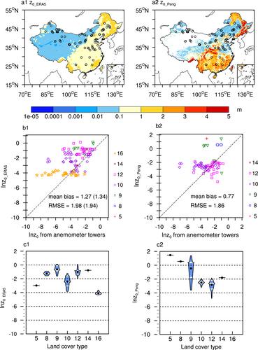
Aerodynamic roughness length () fundamentally affects land surface momentum loss and wind resource simulation, but ground truth data of are sparse in space, causing datasets used in atmospheric models are empirically estimated from land cover types through a look-up table. In this study, we derived values from 101 anemometer towers in China. Taking them as ground truth, we show that existing gridded datasets determined from either a look-up table or a machine-learning method contain considerable uncertainty and fail to capture the variability of within each land cover type, although the latter performs better. Even for the widely used ERA5, its is overestimated in wind-rich regions of China, causing an underestimation of near-surface wind speed. This highlights the necessity to improve data in atmospheric models. Current rapidly expanding anemometer towers may substantially enrich truth data and thus provide potential to improve wind resource modeling.
期刊介绍:
Geophysical Research Letters (GRL) publishes high-impact, innovative, and timely research on major scientific advances in all the major geoscience disciplines. Papers are communications-length articles and should have broad and immediate implications in their discipline or across the geosciences. GRLmaintains the fastest turn-around of all high-impact publications in the geosciences and works closely with authors to ensure broad visibility of top papers.


 分享
分享
 求助内容:
求助内容: 应助结果提醒方式:
 扫码关注我们
